Haptic GPS Sneakers For The Visually Impaired

gps_haptic_shoe

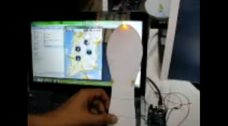
The world can be a pretty difficult place to navigate when you lack the ability to see it. There are many visually impaired people across the globe, with some figures claiming up to 40 million individuals affected. While walking canes and seeing-eye dogs can be a huge help, [Anirudh] of Multimodal Interactions Group, HP Labs India, and some students at the College of Engineering in Pune, India (COEP) have been hard at work constructing a haptic navigation system for the blind.

[Anirudh Sharma and Dushyant Mehta] debuted their haptic feedback shoe design during an MIT Media Lab Workshop hosted at COEP. In its current form, Google Maps and GPS data is sourced from an Android device, which is fed to an Arduino via Bluetooth. The Arduino then activates one of four LEDs mounted on a shoe insert that are used to indicate which direction the individual should travel in order to safely reach their destination. While the current iteration uses LEDs, they will be swapped out for small vibrating motors in the final build.

We’re always fans of assistive technology hacks, and we think this one is great. The concept works well, as we have seen before, so it’s just a matter of getting this project refined and in the hands shoes of those who need it.

Stick around for a quick video about the project filmed at the MIT/COEP event.

Continue reading “Haptic GPS Sneakers For The Visually Impaired”

GPS-enabled Bag Allows For Carefree City Roaming

mapbag_lilypad

[Josh] was looking for a way to enjoy exploring the city of Chicago safely, and hacked together a messenger bag navigation system to ensure he always knew where he was going.

While riding, he wanted to embrace the idea of Dérive, but he felt that he was being too overly conscious of time as well as his location, which took all the fun out of his unplanned excursions. Having recently been “doored” by a car, he was also looking for a way to help him navigate the city streets without being overly distracted with finding his way around.

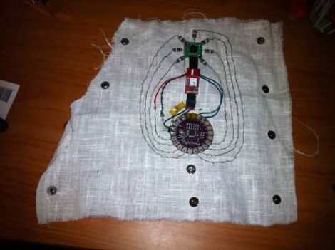
His “Map Bag” solves both of these problems for him, without being obtrusive. He fit a messenger bag with a LilyPad Arduino and a GPS receiver for keeping track of his location. The Arduino can constantly monitor speed, heading, and location, directing [Josh] to his destination by vibrating one of 8 shaftless motors that are installed throughout the bag’s chest strap. Now while he rides, he can take in the city’s atmosphere while also knowing that he will get exactly where he needs to – on time.

He does not have any source code or schematics on his site as of yet, but we hope to see some in the near future. If you are interested, check out the videos of the bag’s construction embedded below.

Continue reading “GPS-enabled Bag Allows For Carefree City Roaming”

Google Maps Wristlet Navigator

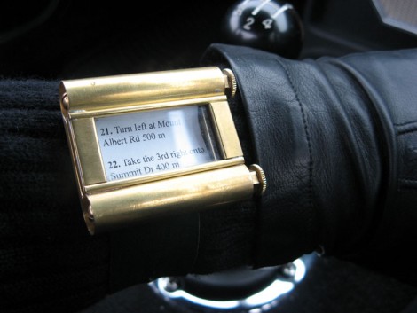
This on-wrist navigation system uses Google Maps and something called… paper. This is a throwback to scroll-based directions from the 1920’s and 30’s that [Simon] built. He soldered a couple of brass tubes to a brass back plate, then added sides and a face crystal. Now he prints out step by step direction from the popular mapping website and winds them onto scrolls. We’re not sure that we’d take the time to do this, but hey, at least the screen resolution is fantastic and you don’t have to worry about battery life.

13th Century Navigation System

[ted id=694]

[Tom Wujec] explains how an astrolabe works and its importance in our technological development. He argues that an astrolabe was the world’s first “popular computer”. It measures the sky and that measurement can be used to tell time, survey land, and navigate a ship.

Astrolabes are built from three pieces and according to [Tom], educated children in the 1200’s would not just have been able to use one, but could build one as well. Electronics have certainly made our lives easier, but there’s something powerful about such a useful yet simple device.

Keychain GPS Finder

gps keychain navigation

With a user interface consisting of two buttons and a three digit display, the GPS finder guides the user back to a saved location. Nine locations can be saved for navigation recall. Press a button to save location and press another button to recall. Each switch has a secondary function, for management purposes such as memory indexes and power features. An AarLogic GPS 3A module and AVR microcontroller make up the guts. With the popularity of Geocaching, this would make an impressive trinket; Leading the hunter to an undocumented treasure.

Tweenbots Rely On Human Help

tweenbots

[Kacie Kinzer] put together an interesting social experiment: Could a robot navigate purely by the help of strangers? She constructed an inexpensive Tweenbot robot that would drive in a straight line. A flag was attached to the top with a plea for help and a destination. Surprisingly, on the first run it was able to traverse through Washington Square Park in just 42 minutes with the help of 29 people. You can see a video of the first run below. This is part of [Kacie]’s thesis work at ITP and she has many other bots planned. While it’s a great demonstration of human kindness, there’s another lesson: If you don’t think your public project looks innocuous enough, draw a smiley face on it.

Continue reading “Tweenbots Rely On Human Help”