Using An Old Satellite To See The Earth In A New Light

Snooping in on satellites is getting to be quite popular, enough so that the number of people advancing the state of the art — not to mention the wealth of satellites transmitting signals in the clear — has almost made the hobby too easy. An SDR, a homebrew antenna, and some off-the-shelf software, and you too can see weather satellite images on your screen in real time.

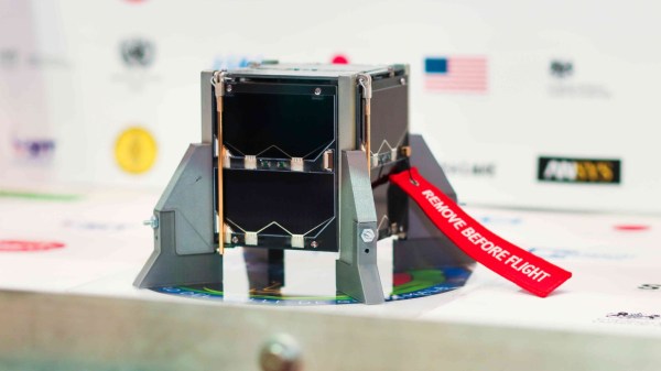
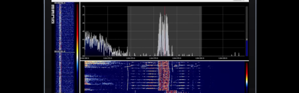
But where’s the challenge? That seems to be the question [dereksgc] asked and answered by tapping into S-band telemetry from an obsolete satellite. Most satellite hunters focus on downlinks in the L-band or even the VHF portion of the spectrum, which are within easy reach of most RTL-SDR dongles. However, the Coriolis satellite, which was launched in 2003, has a downlink firmly in the S-band, which at 2.2-GHz puts it just outside the high end of an RTL-SDR. To work around this, [dereksgc] bought a knock-off HackRF SDR and couple it with a wideband low-noise amplifier (LNA) of his own design. The dish antenna is also homebrewed from a used 1.8-m dish and a custom helical antenna for the right-hand circular polarized downlink signal.

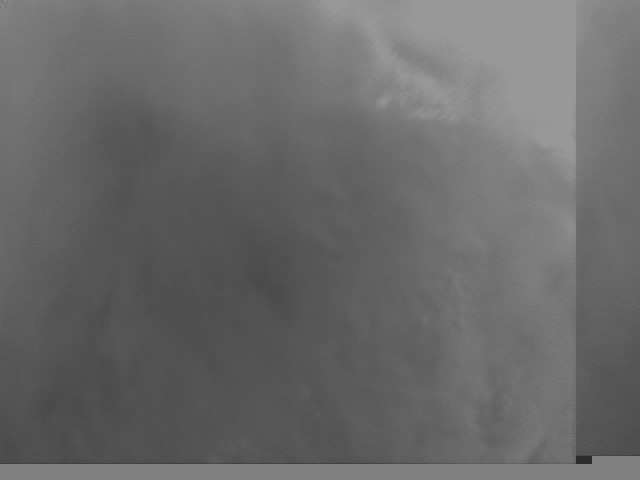
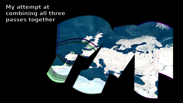
As the video below shows, receiving downlink signals from Coriolis with the rig wasn’t all that difficult. Even with manually steering the dish, [dereksgc] was able to record a couple of decent passes with SDR#. Making sense of the data from WINDSAT, a passive microwave polarimetric radiometer that’s the main instrument that’s still working on the satellite, was another matter. Decoded with SatDump and massaged with Gimp, the microwave images of Europe are at least recognizable, mostly due to Italy’s distinctive shape.

Despite the distortion, seeing the planet’s surface via the microwaves emitted by water vapor is still pretty cool. If more traditional weather satellite images are what you’re looking for, those are pretty cool too.

Continue reading “Using An Old Satellite To See The Earth In A New Light”

Russian Weather Satellite Reuses Name, Yields Images

Which Russian weather satellite has the name Meteor 2? According to [saveitforparts], pretty much all of them. He showed how to grab images from an earlier satellite with the same name a while back. That satellite, though, met with some kind of disaster, so he’s posted a new video about reading data from the new Meteor 2 and you can watch it below.

The interesting part, we thought, was that the software he’s using, Raspberry-NOAA v2, doesn’t know about this incarnation of the bird which has only been up for a few weeks. That means he had to find a satellite with similar orbital parameters. Eventually, the program will have the setup for this satellite.

Continue reading “Russian Weather Satellite Reuses Name, Yields Images”

Quetzal-1 Satellite Goes Open Source

Back in 2020, students from Universidad Del Valle De Guatemala (UVG) pulled off a really impressive feat, designing and building a CubeSat that lasted a whopping 211 days in orbit. In addition to telemetry and radio equipment, it carried a black-and-white camera payload.

But it turns out space is hard. The first pictures were solid black or white, with the automatic exposure process failing pretty badly. A pair of good pictures were taken by waiting until the satellite was passing over Guatemala during sunrise or sunset. A hung I2C bus led to battery drain, and the team tried a system reset to clear the hung state. Sadly the craft never came back to life after the reset, likely because of one of the Lithium-Ion battery cells failed completely in the low charge state.

That was 2020, so why are we covering it now? Because the project just released a massive trove of open source design documents, the software that ran on the satellite and ground station, and all the captured telemetry from the flight. It’s the ultimate bootstrap for anyone else designing a CubeSat, and hopefully provides enough clues to avoid some of the same issues.

Even though the mission had problems, it did achieve a lot of milestones, including the first picture of Earth taken by a Central American satellite. Even coming online and making radio contact from orbit to an earthbound station is quite a feat. The team is already looking forward to Quetzal-2, so stay tuned for more!

And if you want the details on the Quetzal-1 design, and what went wrong with the electrical system, both PDF papers have been released. Seeing more open source in space is an encouraging development, and one that should continue to grow as the cost of payloads to orbit continues to fall. We’ve covered the UPSat satellite, the PyCubed framework, and even the RTL-SDR for listening to satellite radio traffic.

An All Sky Camera To Watch The Night Sky

If you have any astronomer friends you’ll soon discover that theirs is a world of specialist high-quality optical equipment far ahead of the everyday tinkerer, and for mere mortals the dream of those amazing deep space images remains out of reach. It’s not completely impossible for the night sky to deliver impressive imagery on a budget though, as [David Schneider] shows us with a Raspberry Pi powered whole sky camera.

The project was born of seeing a meteor and idly wondering whether meteorite landing sites could be triangulated from a network of cameras, something he quickly discovered had already been done with some success. Along the way though he found the allsky camera project, and decided to build his own. This took the form of a Raspberry Pi 3 and a Pi HQ camera with a wide-angle lens mounted pointing skywards under an acrylic dome. It’s not the Hubble Space Telescope by any means, but the results are nevertheless impressive particularly in a timelapse. We wish there were less light pollution where we live so we could try it for ourselves.

Long-term readers may remember that this isn’t the first Pi sky camera we’ve brought you, for example this one is from 2020.

Continue reading “An All Sky Camera To Watch The Night Sky”

Democratizing Space, One Picosatellite At A Time

There was a time when putting an object into low Earth orbit was the absolute pinnacle of human achievement. It was such an outrageously expensive and complex undertaking that only a world superpower was capable of it, and even then, success wasn’t guaranteed. As the unforgiving physics involved are a constant, and the number of entities that could build space-capable vehicles remained low, this situation remained largely the same for the remainder of the 20th century.

Nathaniel Evry

But over the last couple of decades, the needle has finally started to move. Of course spaceflight is still just as unforgiving today as it was when Sputnik first streaked through the sky in 1957, but the vast technical improvements that have been made since then means space is increasingly becoming a public resource.

Thanks to increased commercial competition, putting a payload into orbit now costs a fraction of what it did even ten years ago, while at the same time, the general miniaturization of electronic components has dramatically changed what can be accomplished in even a meager amount of mass. The end result are launches that don’t just carry one or two large satellites into orbit, but dozens of small ones simultaneously.

To find out more about this brave new world of space exploration, we invited Nathaniel Evry, Chief Research Officer at Quub, to host last week’s DIY Picosatellites Hack Chat.

Continue reading “Democratizing Space, One Picosatellite At A Time”

The Voice Of GPS

Tuning into a GPS satellite is nothing new. Your phone and your car probably do that multiple times a day. But [dereksgc] has been listening to GPS voice traffic. The traffic originates from COSPAS-SARSAT, which is a decades-old international cooperative of 45 nations and agencies that operates a worldwide search and rescue program. You can watch a video about it below.

Nominally, a person in trouble activates a 406 MHz beacon, and any of the 66 satellites that host COSPAS-SARSAT receivers can pick it up and relay information to the appropriate authorities. These beacons are often attached to aircraft or ships, but there are an increasing number of personal beacons used by campers, hikers, and others who might be in danger and out of reach of a cell phone. The first rescue from this system was in 1982. By 2021, 3,632 people were rescued thanks to the system.

The satellites that listen to the beacon frequencies don’t process the signals. They use a transponder that re-transmits anything it hears on a much higher downlink frequency. These transponders are always payloads on other satellites like navigation or weather satellites. But because the transponder doesn’t care what it hears, it sometimes rebroadcasts signals from things other than beacons. We were unclear if these were rogue radios or radios with spurious emissions in the translator’s input range.

The video has practical tips on how to tune in several of the satellites that carry these transponders. Might be a fun weekend project with a software-defined radio.

We’ve seen homebrew satellite devices, but none for an emergency beacon — we aren’t sure what the legal aspects of that would be. There are other satellites that unknowingly host pirate radio stations, too.

Continue reading “The Voice Of GPS”

China Plans Its Own Megaconstellation To Challenge Starlink

Satellite internet used to be a woeful thing. Early networks relied on satellites in geostationary orbits, with high latency and minimal bandwidth keeping user demand low. That was until Starlink came along, and provided high-speed, low-latency internet access using a fleet of thousands of satellites in Low Earth orbit.

Starlink has already ruffled feathers due to concerns around light pollution and space junk in particular. Now, it appears that China may be readying its own competing constellation to avoid being crowded out of low orbits by the increasingly-popular service.

Continue reading “China Plans Its Own Megaconstellation To Challenge Starlink”