Adding Drone Instrumentation With No Additional Parts

Soon the skies will be filled with drones, or so the conventional wisdom goes, and these flying droids will deliver pizza, mail, packages, and medical supplies right to one of the taller trees in our backyards. To date, advanced fixed-wing UAVs and toy quadcopters have proven themselves to be exceptionally dumb; they have no idea what their airspeed is, and no, ground speed measured by GPS will not keep you in the air.

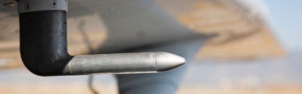
The sensors to measure airspeed and angle of attack can be adapted to small drones, but [gallinazo] has a better idea: why not estimate these figures using sensors a drone already has? He’s measuring synthetic airspeed, something that would have already saved a few hundred lives if it were implemented passenger airliners.

Small drones are able to take a few measurements of their surroundings using standard accelerometers, magnetometers, and of course recording the position of the throttle and control surfaces. All of these variables are related to airspeed – at a constant throttle setting, with no movement of the control surfaces, an aircraft will eventually settle at a stable airspeed.

The trick, though, is to tie all of these variables together to produce a number related to the airspeed of the drone. This is done with a Python script implementing a radial basis function and eating all the memory on [gallinazo]’s desktop. This Python script is effectively a black box that turns the throttle position, bank angle, elevator position, and pitch rate into an airspeed.

Does this black box work? Judging by the graphs comparing synthetic airspeed to measured airspeed, this is amazing work. [gallinazo]’s airspeed estimator accurately and reliably matches the measured airspeed. It does this with zero extra parts on the airframe.

All of the code required to implement this synthetic airspeed indicator is available on GitHub, and could conceivably be implemented in a small RC plane after all the variables are pre-computed. Awesome work that pushes the state of the art forward quite a bit.


UK Government To Hold Drone Licensing Consultation

All over your TV and radio this morning if you live in the UK is the news that the British government is to hold a consultation over the licensing of multirotors, or drones as they are popularly known. It is being reported that users will have to sit a test to acquire a licence before they can operate any machine that weighs above 250 g, and there is the usual fog of sloppy reporting that surrounds any drone story.

This story concerns us on several fronts. First, because many within our community are multirotor enthusiasts and thus we recognise its importance to our readership. And then because it takes as its basis of fact a series of reported near misses with aircraft that look very serious if taken at face value, but whose reported facts simply don’t match the capabilities of real multirotors. We’ve covered this issue in the past with an incident-by-incident analysis, and raised the concern that incident investigators behave irresponsibly in saying “It must have been a drone!” on the basis of no provable evidence. Indeed the only proven British collision was found to have been with a plastic bag.

Of course irresponsible multirotor fliers who threaten public safety should be brought to book. Lock them up, throw away the key, whatever is appropriate. But before that can be done, any debate must be conducted on a level playing field. Our final concern is that this is an issue which is being framed almost entirely on the basis of one side’s interest groups and hysteria on the part of the uninformed about a new technology, rather than a balanced examination of the issues involved. It’s the old “People are having fun. This must be stopped!” idea that infects so much lawmaking, and it’s not very pretty.

Fortunately while it is being reported in some quarters as a done deal as in “Drone fliers must sit a test”, in fact this story is “The Government will ask people what they think about drone fliers sitting a test”. It’s a consultation, which means a Parliamentary committee will sit down and hear evidence before deciding on any legislation. The good news about consultations is that they are open to submissions from the general public, so if you are a British multirotor flier you can submit your own arguments. We will keep you posted with any news about the consultation as we have it.

Header image: 최광모 [CC BY-SA 4.0], via Wikimedia Commons.

Be Your Own Google Mapper

Google Maps is one of the modern wonders of the world. It is hard to remember how expensive it used to be to get high-quality aerial  images. Of course, you don’t get to pick when they fly over a particular piece of the planet. If you are like [Dennis Baldwin] that’s not good enough. He’s been using his drone to document the construction of a high school stadium.

[Dennis] uses the open-source GDAL tools to create Google Map tiles from drone imagery. Even better, he’s documented the process in the video you can find below. Once you can make your own map tiles, you can control when you take the images — important if you are documenting construction like [Dennis] did.

Continue reading “Be Your Own Google Mapper”

Make Use Of Your Drone Video With WebODM

If you ever watch the original Star Trek, Captain Kirk and crew spend a lot of time mapping new parts of the galaxy. In fact, at least one episode centered on them taking images of some new part of space. It might not be new, but if you have a drone, you probably have accumulated a lot of frames of aerial imagery from around your house (or wherever you fly).

WebODM allows you to create georeferenced maps, point clouds and textured 3D models from your drone footage. The software is really an integration and workflow manager for Open Drone Map, which does most of the heavy lifting.

Continue reading “Make Use Of Your Drone Video With WebODM”

Lighthouse Locates Drone; Achieves Autonomous Battery Swap

The HTC Vive’s Lighthouse localization system is one of the cleverest things we’ve seen in a while. It uses a synchronization flash followed by a swept beam to tell any device that can see the lights exactly where it is in space. Of course, the device has to understand the signals to figure it out.

[Alex Shtuchkin] built a very well documented device that can use these signals to localize itself in your room. For now, the Lighthouse stations are still fairly expensive, but the per-device hardware requirements are quite reasonable. [Alex] has the costs down around ten dollars plus the cost of a microcontroller if your project doesn’t already include one. Indeed, his proof-of-concept is basically a breadboard, three photodiodes, op-amps, and some code.

His demo is awesome! Check it out in the video below. He uses it to teach a quadcopter to land itself back on a charging platform, and it’s able to get there with what looks like a few centimeters of play in any direction — more than good enough to land in the 3D-printed plastic landing thingy. That fixture has a rotating drum that swaps out the battery automatically, readying the drone for another flight.

If this is just the tip of the iceberg of upcoming Lighthouse hacks, we can’t wait!

Continue reading “Lighthouse Locates Drone; Achieves Autonomous Battery Swap”

Drone Vs. Airplane? Who Will Win? Science Knows.

Ignore the article, watch the video at the top of the page. The article is about some idiot, likely not even a hacker, who bought a drone somewhere and nearly rammed it into a plane. He managed this with concentrated idiocy, intention was not involved. While these idiots are working hard to get our cool toys taken away, researchers elsewhere are answering the question of exactly how much threat a drone poses to an airplane.

droneexplode_thumb
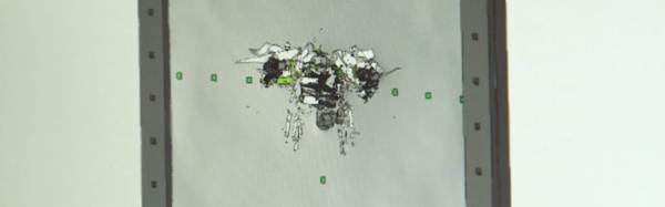
Airplanes are apparently armored to withstand a strike from an 8lb bird. However, even if in a similar weight class, a drone is not constructed of the same stuff. To understand if this mattered, step one was to exactly model a DJI Phantom and then digitally launch it at various sections of a very expensive airplane.

The next step, apparently, was to put a drone into an air cannon and launch it at an aluminum sheet. The drone explodes quite dramatically. Some people have the best jobs.

The study is still ongoing, but from the little clips seen; the drone loses. Along with the rest of us.

Perhaps the larger problem to think about right now is how to establish if a “drone” has actually been involved in an incident with a passenger aircraft. It seems there are a lot of instances where that claim is dubious.

Archaeology, Virtually.

Drone technology is seeing useful application in a new field seemingly every day — so it was only a matter of time before it saw use in archaeology. And so, a team of researches in Australia are combining drone and VR modeling technology to help investigate the Plain of Jars, in Laos.

After the drone images the site, those photos are patched together by object recognition software and are reviewed in the immersive CAVE2 3D facility at Melbourne, Australia’s Monash University. Multiple surveys catalog and archive the dig at various stages and enable the archaeologists to continue investigating the site after leaving — especially useful for digs in dangerous regions. In this case, the landscape around the Plain of Jars is dotted with unexploded cluster bomblets.

Continue reading “Archaeology, Virtually.”