Dash Express Now Twittering


Here’s a quick hack to satiate our appetite for location aware applications. The Dash Express is a GPS unit with cellular and WiFi radios so it can do two way communication. Out of the box it can download maps and traffic on the fly. A little while ago they opened up the API so the device could receive info from other web services and owners could give feedback, like reporting speed traps live. The handy hack embedded above publishes your location to Twitter; we would have preferred it hit an actual location service like Brightkite. This just the tip of the iceberg when it comes to possible applications. We wonder what the adoption rate of the Dash Express will be, since the iPhone also has a touchscreen, GPS, and of course a cellular connection.

We’ve got a Dash Express in the lab and it’s based on the OpenMoko design. What sort of tomfoolery would you like to see us do with it? What do you think the killer app for the Dash Express will be?

[via Gizmodo]

Laser Insect Photography Rig


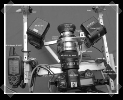
[Marc] sent in this awesome insect photography rig. The camera is manually pre-focused and set for a 30 second exposure at ISO100. The aluminum cylinder in front of the lens is an external shutter mounted with a custom turned lens adapter. It’s used because the built in shutter is too slow for insect capture. The camera/shutter is triggered by a pair of lasers with photo detectors. When both beams are broken, the insect should be in front of the lens. A Garmin GPS provides position information that’s tagged on the image by the Nikon D200. A large photo of the rig is here, while a more detailed writeup on building it is here.

Update: It looks like we covered a previous version of this rig, but the old links are down and we didn’t have a shot of the setup. Oh, and I forgot to mention [Marc] new control box for running this rig.

Location Aware Task Tracking


With the iPhone finally getting legitimate GPS we’re bound to see more widespread use of location based apps. Services like Dodgeball, Brightkite, and a few Twitter clients have been around, but failed to tightly integrate with the hosting phone. Now we’re seeing applications that reach beyond just “finding your friends”. [Merlin Mann] directed us to the version of OmniFocus for the iPhone. OmniFocus is a task management system that’s now location aware thanks to the iPhone. This means it knows to show you your grocery list while you’re at the store and work tasks while you’re at work. Passive interaction could really make similar systems a lot more enjoyable to use.

We think this is just the tip of the iceberg. Imagine alternate reality gaming that gives you a virtual map while you navigate the real world. Geocaching, road rallies, and scavenger hunts could have a running narrative displayed as you progressed. Using technologies like GeoRSS will let us pull data back into the real world making that rare trip outside a lot less painful.

Recent News Followup


Last week we talked about a single rumored arrest over the OiNK torrent tracker. Since then, there’s been a confirmed report of 6 arrests. The arrests appear to be the result of users uploading pre-release music to the now defunct site. For some time, police have had access to the OiNK user records minus the passwords which are thought to be stored as a salted MD5 hash. It seems British authorities can force these individuals to reveal passwords under something called the Regulation of Investigatory Powers Act.

The Phoenix Mars Lander (pictured above) has found what might be a large piece of ice directly underneath it. This week the lander will scoop up a sample, melt its contents and test the various gases it releases. Twitter users can watch the mission’s progress in semi real time by following the MarsPhonix account. Lastly it looks like the official website for this mission was defaced through a SQL injection attack.

We already reported the world’s largest GPS drawing as a hoax. It has however inspired a few to look closer at the concept of position based art and others have already created authentic works. Our friends over at BoingBoing even made a little flash application to create your own “Unimpressive GPS Art“. Upon hearing of the hoax we were quick to draw up a brand new proposal for DHL using Google maps.

Biggest Drawing In The World Created With GPS


UPDATE: The text: “This is fictional work. DHL did not transport the GPS at any time” has been added to the bottom of the page since the original posting.

Artist [Erik Nordenankar] has created the Biggest Drawing In The World. At least that’s what his URL says. He used the movement of a GPS device to create a giant single line self portrait on the globe. His Pelican case containing four large batteries and the GPS data logger was handed off DHL with very specific travel instructions for its 55 day journey. It’s a pretty amazing feat, but we really wish the case had managed to make the trip without the close watch shown in the video.

Continue reading “Biggest Drawing In The World Created With GPS”

Hack-upgrade Your Magellan GPS


[dgoeken] sent in his Magellan 3100 hack. The device runs Windows CE 5.0, and mounts as a standard flash drive. Since everything is easily accessible, it’s just a matter of replacing and modifying the appropriate files. According to the GpsPassion message board, some are finding his guide useful for other models of Magellan GPS. So far he’s added a file manager, media player and upgraded the Points of Interest file. The site is slightly bandwidth challenged, so I’ve mirrored his hack process here.