South Korea’s KSLV-2 Rocket Delivers Payloads To Orbit

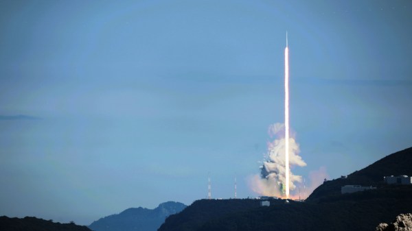
South Korea’s domestically developed KSLV-2 “Nuri” rocket successfully placed six payloads into low Earth orbit Tuesday, after lifting off from from Naro Space Center at 4 PM KST. This follows an earlier attempt in October which failed to reach orbit after the booster’s third stage engine shutdown prematurely. The flight followed an initial trajectory over the East China Sea, after which the upper stage steered out towards the Philippine Sea, finally placing the payload in the desired orbital inclination of 98 degrees. This less-than-ideal path wasted energy, but ensured that the first and second stages fell into the ocean and not onto people. Success was confirmed shortly after launch as the vehicle passed over South Korea’s King Sejong Station in Antarctica.

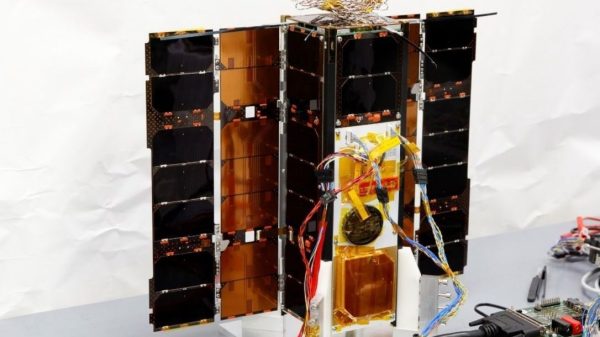
The payload on this test flight was primarily a mass simulator of 1.3 metric tons, but a small Performance Verification Satellite (PVSAT) was included, for a grand total of 1.5 metric tons. The PVSAT itself monitors vehicle performance, but also serves as a carrier for four CubeSats. These were developed by engineering teams at various local universities and will be deployed in the coming days.

If you’re inclined to track these, the launch has been given COSPAR ID 2022-065 and the first three objects (third stage, dummy mass, and PVSAT) have been assigned the NORAD catalog numbers 52894, 52895, and 52896. It’s too early to tell which is which at this point, but as more data about their respective orbits are collected, it should be possible to tell them apart. The next four catalog numbers, 52897 – 52900, have been reserved for the CubeSats once they are released.

With this launch, South Korea has become the 10th nation to put a payload into space using its own domestic technology, and the 7th to loft a payload of more than one ton to orbit — joining the ranks of the United States, Russia, Japan, China, France, and India.

Continue reading “South Korea’s KSLV-2 Rocket Delivers Payloads To Orbit”

The Great Euro Sat Hack Should Be A Warning To Us All

Military officials and civilian security researchers have been warning us for years: cyberattacks are becoming a very real part of modern warfare. Far from being limited to military targets, cyberattacks can take out everything from vital public infrastructure to commercial and industrial operations, too.

In the early hours of February 24, as the Russian invasion force began raining missiles on Ukrainian cities, another attack was in progress in the digital realm. Suddenly, satellite terminals across Europe were going offline, with many suffering permanent damage from the attack.

Details remain hazy, but researchers and military analysts have pieced together a picture of what happened that night. The Great Euro Sat Hack prove to be the latest example of how vulnerable our digital infrastructure can be in wartime.

Continue reading “The Great Euro Sat Hack Should Be A Warning To Us All”

Mercury Thrusters: A Worldwide Disaster Averted Just In Time

The field of space vehicle design is obsessed with efficiency by necessity. The cost to do anything in space is astronomical, and also heavily tied to launch weight. Thus, any technology or technique that can bring those figures down is prime for exploitation.

In recent years, mercury thrusters promised to be one such technology. The only catch was the potentially-ruinous environmental cost. Today, we’ll look at the benefits of mercury thrusters, and how they came to be outlawed in short order.

Continue reading “Mercury Thrusters: A Worldwide Disaster Averted Just In Time”

Hacking An Experimental ESA Satellite

Hacking these days means everything from someone guessing your password and spamming your contacts with toxic links, to wide-scale offensive cyberattacks against infrastructure by sophisticated operators backed by nation states. When it comes to hacking satellites, though, [Didelot Maurice-Michel] found himself tangling with some hardware belonging to the European Space Agency. 

As part of an event called HackCYSAT, hackers were invited to attack the ESA’s OPS-SAT, a CubeSat intended to demonstrate improved techniques for mission control and more advanced satellite hardware. The computer hardware on board is ten times more powerful than other existing ESA satellites, and aims to take satellite technology on a new leap forward.

Continue reading “Hacking An Experimental ESA Satellite”

Tune Your Dish Antenna Like A Pro

It’s a problem we all have at one time or another: your five-meter radio astronomy dish gets out of calibration and you don’t have a ridiculously expensive microwave holography rig on hand to diagnose it. OK, maybe this isn’t your problem, but when [Joe Martin]’s parabolic antenna got out of whack, he set out to diagnose and repair it, and then wrote up how he did it. You can download the PDF from his radio astronomy articles collection.

At the heart of the measurement rig is a laser rangefinder connected to a Porcupine Labs interface that passes the data on to a Pi 4. This is placed on the end of a two-degree-of-freedom servo gimbal that scans over the surface of the dish, measuring its shape. After measuring and math, [Joe] found out that it’s a little bit long here and short there, he attached two cables with turnbuckles to the front of the dish and pulled it back into shape — the sort of thing that you should probably only do if you’ve got a measurement rig already set up.

The Fluke rangefinder and Porcupine labs interface combo is pretty sweet, but it comes with a fairly hefty price tag. (Nothing compared to a professional dish measurement rig, we presume.) We’ve seen a few attempt at hacking into el-cheapo laser rangefinders, but other than [iliasam]’s heroic effort where he ended up writing his own firmware, it doesn’t seem like there are any successes. A shame, because applications like [Joe]’s prove that there’s a need for one. Let us know if there’s anything we missed?

Thanks [Ethan] for the tip!

Satellite Snoopers Pick Up Surprising TV Broadcast

While Internet based streaming services appear to be the future of television, there are still plenty of places where it comes into the home via a cable, satellite, or antenna connection. For most satellite transmissions this now means a digital multiplex carrying a host of channels from a geostationary satellite, for which a set-top box or other decoder is required. Imagine the surprise of satellite-watchers than when the Russian polar communications satellite Meridian 9 which has a highly elliptical orbit was seen transmitting old-style terrestrial analogue TV (ThreadReader Link). What on earth was happening?

How a Russian polar comms satellite picked up a TV station.

The TV signal in question comes from Turkmenistan, so were some homesick Turkmenistanis in an Antarctic base being treated to a taste of their country? The truth is far more interesting than that, because the signal in question comes from a terrestrial transmitter serving domestic TV viewers in Turkmenistan.

We’ve all heard of the idea that somehow every TV show ever transmitted is somewhere out there still traveling as radio waves across space, and while perhaps we can’t fly far enough out to check for 1960s Doctor Who episodes it’s true that the horizontal transmissions from a TV tower pass out into space as the earth curves away from them.

Thus Meridian 9 passed through the beam from the Turkmenistan transmitter which happened to be on a UHF frequency that matched one of its transponders, and the result was an unexpected bit of satellite TV. We’re indebted to the work of [@dereksgc] and [Scott Tilley] for bringing us this fascinating observation. We’ve featured [Scott]’s work before, most notably when he relocated a lost NASA craft.

You Can Find Military Radars On Publicly-Available Satellite Data

When it comes to hunting down military radar installations and associated hardware, we typically think of equipment that is firmly in the price bracket of nation states and their military forces. Whether it’s early warning radar, those used for air defence, or for naval purposes, you’d think it was relatively difficult to intercept or track these emissions.

However, a new tool built by geocomputation lecturer Ollie Ballinger shows this isn’t the case. In fact, openly-available data captured via satellite can be used to find all manner of military radar emitters. Let’s explore how!

Continue reading “You Can Find Military Radars On Publicly-Available Satellite Data”