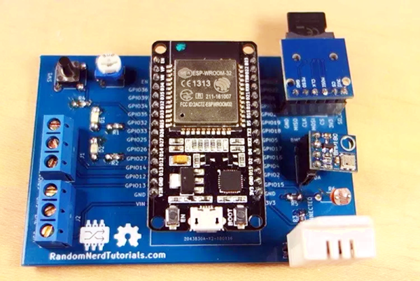
We see lots of ESP8266 projects, but considerably fewer for the ESP32. So this good-looking weather station on a PCB using an ESP32 caught our eye. The board has a few sockets for common weather gear, but with a little modification, it would be a great carrier for an ESP32. Since the PCB layout is available, you could change things around to suit you. You can see a video from [Rui Santos] about his project and its progress from breadboard to PCB in the video below.
weather station63 Articles
Retrotechtacular: Weather Station Kurt
Sometimes when researching one Hackaday story we as writers stumble upon the one train of thought that leads to another. So it was with a recent look at an unmanned weather station buoy from the 1960s, which took us on a link to a much earlier automated weather station.
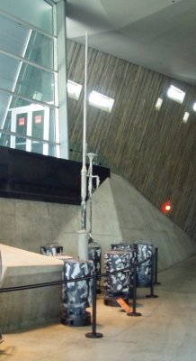
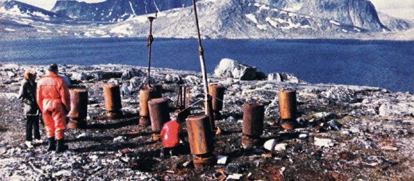
Weather Station Kurt was the only successful installation among a bold attempt by the German military during the Second World War to gain automated real-time meteorological data from the Western side of the Atlantic. Behind that simple sentence hides an extremely impressive technical and military achievement for its day. This was the only land-based armed incursion onto the North American continent by the German military during the entire war. Surrounded as it was though by secrecy, and taking place without conflict in an extremely remote part of Northern Labrador, it passed unnoticed by the Canadian authorities and was soon forgotten as an unimportant footnote in the wider conflagration.
Kurt took the form of a series of canisters containing a large quantity of nickel-cadmium batteries, meteorological instruments, a telemetry system, and a 150W high frequency transmitter. In addition there was a mast carrying wind speed and direction instruments, and the transmitting antenna. In use it was to have provided vital advance warning of weather fronts from the Western Atlantic as they proceeded towards the European theatre of war, the establishment of a manned station on enemy territory being too hazardous.
A small number of these automated weather stations were constructed by Siemens in 1943, and it was one of them which was dispatched in the U-boat U537 for installation on the remote Atlantic coast of what is now part of modern-day Canada. In late October 1943 they succeeded in that task after a hazardous trans-Atlantic voyage, leaving the station bearing the markings of the non-existent “Canadian Meteor Service” in an attempt to deceive anybody who might chance upon it. In the event it was not until 1977 that it was spotted by a geologist, and in 1981 it was retrieved and taken to the Canadian War Museum.
There is frustratingly little information to be found on the exact workings on the telemetry system, save that it made a transmission every few hours on 3940kHz. A Google Books result mentions that the transmission was encoded in Morse code using the enigmatic Graw’s Diaphragm, a “sophisticated contact drum” named after a Dr. [Graw], from Berlin. It’s a forgotten piece of technology that defies our Google-fu in 2017, but it must in effect have been something of a mechanical analogue-to-digital converter.
Should you happen to be visiting the Canadian capital, you can see Kurt on display in the Canadian War Museum. It appears to have been extensively restored from the rusty state it appears in the photograph taken during its retrieval, it would be interesting to know whether anything remains of the Graw’s Diaphragm. Do any readers know how this part of the station worked? Please let us know in the comments.
Weather station Kurt retrieval image, Canadian National Archives. (Public domain).
Weather station Kurt in museum image, SimonP (Public domain).
Retrotechtacular: An Oceanographic Data Station Buoy For The 1960s
When we watch a TV weather report such as the ones that plaster our screens during hurricane season, it is easy to forget the scale of the achievement they represent in terms of data collection and interpretation. Huge amounts of data from a diverse array of sources feed weather models running on some of our most powerful computers, and though they don’t always forecast with complete accuracy we have become used to their getting it right often enough to be trustworthy.
It is also easy to forget that such advanced technology and the vast array of data behind it are relatively recent developments. In the middle of the twentieth century the bulk of meteorological data came from hand-recorded human observations, and meteorologists were dispatched to far-flung corners of the globe to record them. There were still significant areas of meteorological science that were closed books, and through the 1957 International Geophysical Year there was a concerted worldwide effort to close that gap.
We take for granted that many environmental readings are now taken automatically, and indeed most of us could produce an automated suite of meteorological instruments relatively easily using a microcontroller and a few sensors. In the International Geophysical Year era though this technology was still very much in its infancy, and the film below the break details the development through the early 1960s of one of the first automated remote ocean sensor buoys.
Perhaps our last sentence conjures up a vision of something small enough to hold, from all those National Geographic images of intrepid oilskin-clad scientists launching them from the decks of research vessels. But the technology of the early 1960s required something a little more substantial, so the buoy in question is a (using the units of the day) 100 ton circular platform more in the scale of a medium-sized boat. Above deck it was dominated by an HF (shortwave) discone antenna and its atmospheric instrument package. Below deck (aside from its electronic payload) it had a propane-powered internal combustion engine and generator to periodically charge its batteries. In use it would be anchored to the sea floor, and it was designed to operate even in the roughest of maritime conditions.
The film introduces the project, then looks at the design of a hull suitable for the extreme conditions like a hurricane. We see the first prototype being installed off the Florida coast in late 1964, and follow its progress through Hurricane Betsy in 1965. The mobile monitoring station in a converted passenger bus is shown in the heart of the foul weather, receiving constant telemetry from the buoy through 40 foot waves and 110 mph gusts of wind.
We are then shown the 1967 second prototype intended to be moored in the Pacific, this time equipped with a computerised data logging system. A DEC PDP-8 receives the data mounted in the bus, and are told that this buoy can store 24 hours at a stretch for transmission in one go. Top marks to the film production team for use of the word “data” in the plural.
Finally we’re told how a future network of the buoys for presumably the late 1960s and early 1970s could be served by a chain of receiving stations for near-complete coverage of the major oceans. At the height of the Cold War this aspect of the project would have been extremely important, as up-to-the-minute meteorological readings would have had considerable military value.
The film makes an engaging look at a technology few of us will ever come directly into contact with but the benefits of which we will all feel every time we see a TV weather forecast.
Continue reading “Retrotechtacular: An Oceanographic Data Station Buoy For The 1960s”
An Arduino Weather Station With An E-Ink Display
For our Northern Hemisphere readers the chill winds of winter are fast approaching, so it seems appropriate to feature a weather station project. Enjoy your summer, Southern readers!
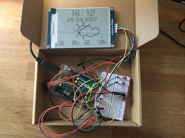
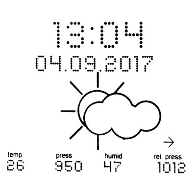 [Fandonov] has created a weather station project with an Arduino Uno at its heart and a Waveshare e-ink display as its face to the world, and as its write-up (PDF) describes, it provides an insight into both some of the quirks of these displays, and into weather forecasting algorithms.
The hardware follows a straightforward formula, aside from Arduino and display it boasts an Adafruit sensor board and a hardware clock. Software-wise though there are some tricks to give the display a scalable font that other tinkerers might find useful, drawing characters as a matrix of filled circle primitives.
The write-up gives an introduction to forecasting based only on local readings rather than on the huge volumes of data over a wide area used by professional meteorologists. In play here is the Zambretti algorithm, which takes the readings and information about whether they are rising or falling, and returns a forecast from a look-up table.
As we’ll all be aware, even professional weather forecasting is fraught with inaccuracies, but this is nonetheless an interesting project that is very much worth a second look. Meanwhile we’ve covered huge numbers of weather stations in the past, a couple of interesting ones are this one using a classic TI99/4A home computer, and more relevant here, this one using an e-paper badge.
Thanks [Phil] for the tip!
TI 99/4A Weather Station
If you still have a drawer full of slap bracelets from the 1990s because, you know, they might come back, then you’ll appreciate [Vorticon’s] latest project. Sure, we see lots of weather stations, but this one is controlled by a TI 99/4A computer. This home computer from the 1980s was actually ahead of its time with a 16-bit processor.
The sensors use Xbee modules and an Arduino Uno. Of course, the Uno has more power than the TI computer, but that’s not really the point, right? He’s made a series of videos detailing the construction (you can see the first one below, but there are five, so far).
IKEA Lantern Houses Full-Featured Weather Station
From plain and utilitarian to the sleek and professional, there are a lot of ways to build a multifunction weather station. We’d thought we’d seen it all here, but building a weather station into an IKEA lantern is a pretty unique presentation.
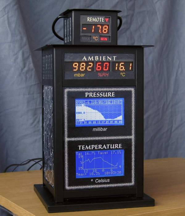
There’s an active community over at ikeahackers.net, and the variety of IKEA hacks they’ve come up with is pretty astounding. For this weather hack, [Richard Stevens] chose the Borrby, a $15 candle lantern. While it doesn’t exactly scream “weather station”, the form factor makes sense – plenty of room for electronics, easily replaced windows, and a nice cupola for mounting extra displays. [Richard]’s build includes a barometer, a hygrometer, and a thermometer, along with graphing displays for trends and historical data. There’s also an alarm clock and a rear panel bristling with more connectors and switches than an 80s-era HP oscilloscope. The wiring is admittedly “rats-nest style”, but as you can see in the video after the break, it works pretty well and looks good too.
Interested in rolling your own non-lantern weather station? Check out this headless Weather Underground sensor suite, or a simple panel of analog meters.
Continue reading “IKEA Lantern Houses Full-Featured Weather Station”
Solar-powered Weather Station Has The Complete Suite Of Sensors
There was a time when getting weather conditions was only as timely or as local as the six o’clock news from the nearest big-city TV station. Monitoring the weather now is much more granular thanks to the proliferation of personal weather stations. For the ultimate in personalized weather, though, you might want to build your own solar powered weather station.
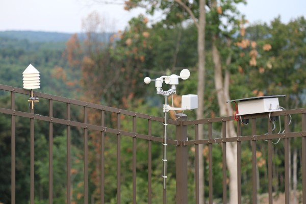
It looks like [Brian Masney] went all out in designing his weather station. It supports a full stack of sensors – wind speed and direction, rain, temperature, pressure, and dew point. About the only other parameters not supported (yet) are solar radiation, UV, and soil moisture and temperature. The design looks friendly enough that adding those sensors should be a snap – if fact, the 3D models in his GitHub repo suggest that he’s already working on soil sensors. The wind and rain sensor boom is an off-the-shelf unit from Sparkfun, and the temperature and pressure sensors are housed in a very professional 3D printed screen enclosure. All the sensors talk to a Raspberry Pi living in a (hopefully) waterproof enclosure topped with a solar panel for charging the stations batteries. All in all it’s a comprehensive build; you can check out the conditions at [Brian]’s place on Weather Underground.
Weather stations are popular around these parts, as witnessed by this reverse-engineered sensor suite or even this squirrel-logic based station.

