Do you know what the IODC word in GPS data means? If so, great! If not, head over to see the 32nd of [Michel van Biezen’s] 100-part video series on GPS. You probably want to watch the other 31 videos before he gets too much further ahead of you, too. [Michel] reminds you of that professor you had in college who knows a whole lot about something. In fact, scanning his YouTube channel, he knows a lot about many topics ranging from optics, chemistry, kalman filters, and lots of electronics.
There is a dedicated playlist for the GPS videos dating back to 2016. So 32 videos in about six years. So you might have a little time to catch up. While the first video is pretty introductory as you might expect, by the time you get to video 7 the topics switch to things like the C/A code, BPSK, and gory details of all the frame data, including the IODC word.
Join Hackaday Editor-in-Chief Elliot Williams and Managing Editor Tom Nardi for a recap of all the best tips, hacks, and stories of the past week. We start things off with an update on Hackaday’s current slate of contests, followed by an exploration of the cutting edge in 3D printing and printables. Next up we’ll look at two achievements in detection, as commercial off-the-shelf hardware is pushed into service by unusually dedicated hackers to identify both dog poop and deep space pulsars (but not at the same time). We’ll also talk about fancy Samsung cables, homebrew soundcards, the surprising vulnerability of GPS, and the development of ratholes in your cat food.
Artificial satellites have transformed the world in many ways, not only in terms of relaying communication and for observing the planet in ways previously inconceivable, but also to enable incredibly accurate navigation. A so-called global navigation satellite system (GNSS), or satnav for short, uses the data provided by satellites to pin-point a position on the surface to within a few centimeters.
The US Global Positioning System (GPS) was the first GNSS, with satellites launched in 1978, albeit only available to civilians in a degraded accuracy mode. When full accuracy GPS was released to the public under the 1990s Clinton administration, it caused a surge in the uptake of satnav by the public, from fishing boats and merchant ships, to today’s navigation using nothing but a smartphone with its built-in GPS receiver.
Even so, there is a dark side to GNSS that expands beyond its military usage of guiding cruise missiles and kin to their target. This comes in the form of jamming and spoofing GNSS signals, which can hide illicit activities from monitoring systems and disrupt or disable an enemy’s systems during a war. Along with other forms of electronic warfare (EW), disrupting GNSS signals form a potent weapon that can render the most modern avionics and drone technology useless.
With this in mind, how significant is the threat from GNSS spoofing in particular, and what are the ways that this can be detected or counteracted?
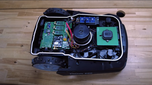
Robotic mowers are becoming a common sight in some places, enabled by the cost of motors and the needed control electronics being much lower, thanks to the pace of modern engineering. But, in many cases, they still appear to be really rather dumb, little more than a jacked up bump-and-go with a spinning blade. [Clemens Elflein] has taken a cheap, dumb mower and given it a brain transplant based around a Raspberry Pi 4 paired up with a Raspberry Pi Pico for the real time control side of things. [Clemens] is calling this OpenMower, with the motivation to create an open source robot mower controller with support for GPS navigation, using RTK for extra precision.
The donor robot was a YardForce Classic 500, and after inspection of the control PCB, it looks like many other robot mower models are likely to use the same controller and thus be compatible with the openmower platform. A custom mainboard houses the Pi 4 and Pico, an ArduSimple RTK GPS module (giving a reported navigational accuracy of 1 cm,) as well as three BLDC motor drivers for the wheels and rotor. Everything is based on modules, plugging into the mainboard, reducing the complexity of the project significantly. For a cheap mower platform, the Yardforce unit has a good build quality, with connectors everywhere, making OpenMower a plug and play solution. Even the user interface on top of the mower was usable, with a custom PCB below presenting some push buttons at the appropriate positions.
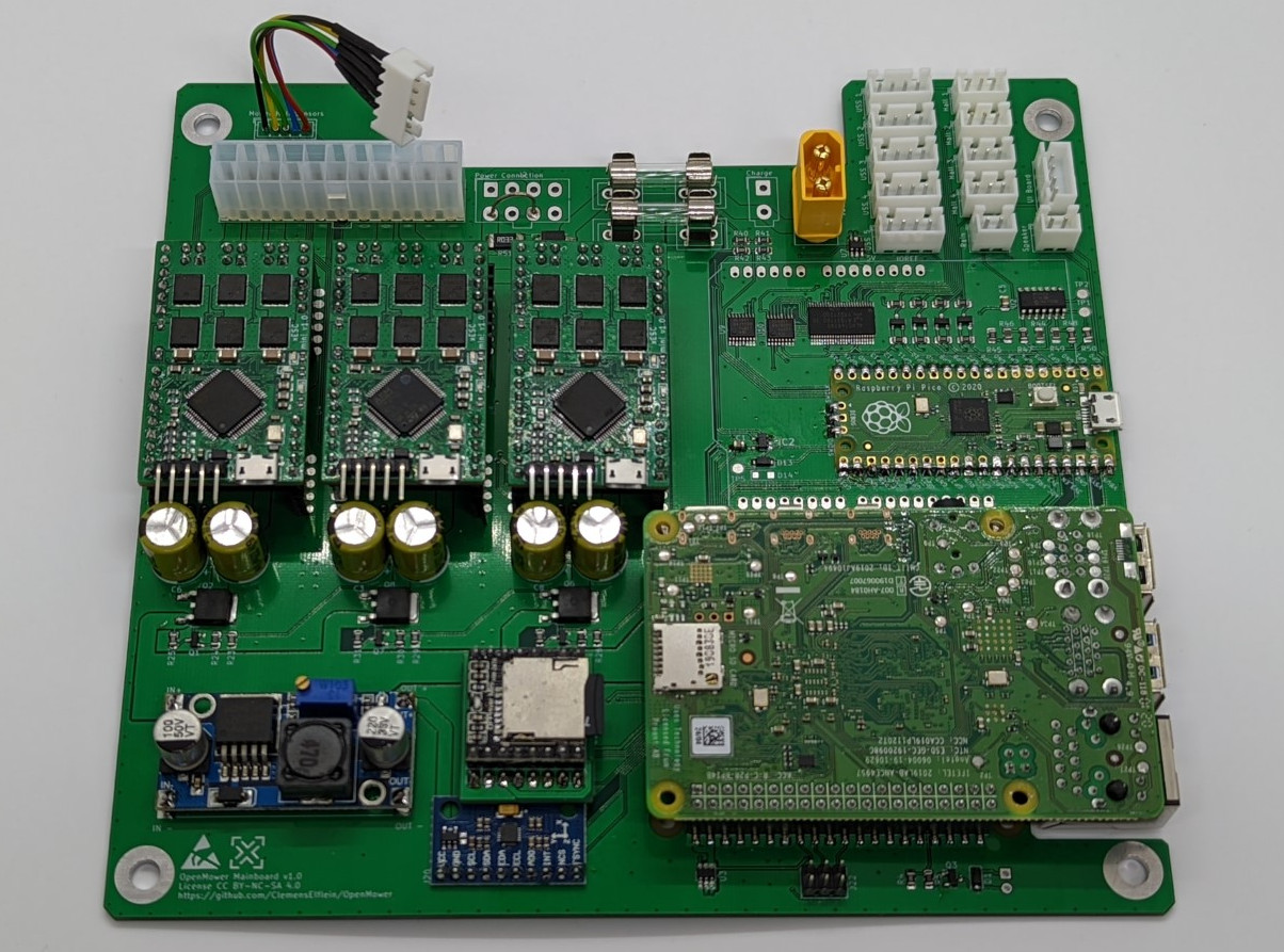
OpenMower mainboard
Motor control is courtesy of the xESC project, which provides FOC motor control for low cost, interfacing with the host controller via a serial link. This is worth looking into in its own right! On the software side of things, [Clemens] is using ROS, which implements the low level robot control, path planning (using code taken from Slic3r) as well a kinematics constraints for object avoidance. The video below, shows how simple the machine is to operate — just drive it around the perimeter of lawn with a handheld controller, and show it where obstacles such as trees are, and then set it going. The mower is even capable of mowing multiple lawns, making the journey between them automatically!
GPS has been a game-changing technology for all kinds of areas. Shipping, navigation, and even synchronization of clocks have become tremendously easier thanks to GPS. As a result of its widespread use, the cost of components is also low enough that almost anyone can build their own GPS device, and [Akio Sato] has taken this to the extreme with efforts to build a GPS tracker that uses the tiniest amount of power.
This GPS tracker is just the first part of this build, known as the air station. It uses a few tricks in order to get up to 30 days of use out of a single coin cell battery. First, it is extremely small and uses a minimum of components. Second, it uses LoRa, a low-power radio networking method, to communicate its location to the second part of this build, the ground station. The air station grabs GPS information and sends it over LoRa networks to the ground station which means it doesn’t need a cellular connection to operate, and everything is bundled together in a waterproof, shock-resistant durable case.
GPS and similar satellite navigation systems changed everything. The modern generation is far less likely to have had to fold a service station map or ask someone for directions on the side of the road. But GPS isn’t perfect. You need to see the sky, for one thing. For another, an adversary could jam or take down your satellites. Even a natural disaster could temporarily or permanently knock out your access to the satellites.
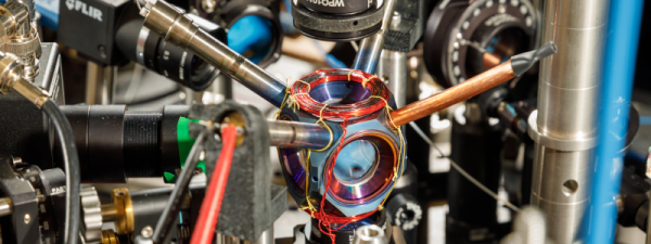
The people at Sandia National Labs worry about things like that and they want to replace GPS with quantum accelerometers and gyroscopes. The problem: those things take expensive and bulky vacuum systems and lasers. Sandia, however, has had a sealed device about the size of an avocado that weighs about a pound that could possibly do the job. Their goal is to see it work without maintenance for four more years.
This is no ordinary vacuum tube, though. It is made of titanium and sapphire. By itself, the device doesn’t do much of anything, but it shows that rubidium can be contained in a sealed chamber with no additional pumping. These quantum sensors aren’t anything new, but a tiny self-contained cold-atom sensor can pave the way for putting these sensors in vehicles like ships, aircraft, and ground vehicles. Submarines, which don’t usually have a clear shot at the sky without floating an antenna, are also candidates for the new technology.
A navigation system based on this technology uses a laser to cool the subject atoms and then measures their movements. This allows very precise determination of acceleration and rotation which allows for a more precise inertial navigation system.
If you need a refresher on how GPS works, we can explain it. If you think the idea of a module containing rubidium is far-fetched, don’t forget you can already get them for precision clock work.
Why? Getting a drone that can fly a path and even return home when the battery is low, signal is lost, or on command, is simple enough. Just go to your favorite retailer, search “gps drone” and you can get away for a shockingly low dollar amount. This is possible because GPS receivers have become cheap, small, light, and power efficient. While all of these inexpensive drones can fly a predetermined path, they usually do so by flying over any obstacles rather than around.
[Nick Rehm] has envisioned a quadcopter that can do all of the things a GPS-enabled drone can do, without the use of a GPS receiver. [Nick] makes this possible by using algorithms similar to those used by Google Maps, with data coming from a typical IMU, a camera for Computer Vision, LIDAR for altitude, and an Intel RealSense camera for detection of position and movement. A Raspberry Pi 4 running Robot Operating System runs the autonomous show, and a Teensy takes care of flight control duties.
What we really enjoy about [Nick]’s video is his clear presentation of complex technologies, and a great sense of humor about a project that has consumed untold amounts of time, patience, and duct tape.


![[Nick Rehm] explains the workings of a gps-less self guided drone](https://hackaday.com/wp-content/uploads/2021/10/gpsless-drone-featured.jpg?w=600&h=450)