The Satellite Phone You Already Own: From Orbit, UbiquitiLink Will Look Like A Cell Tower

For anyone that’s ever been broken down along a remote stretch of highway and desperately searched for a cell signal, knowing that a constellation of communications satellites is zipping by overhead is cold comfort indeed. One needs specialized gear to tap into the satphone network, few of us can justify the expense of satellite phone service, and fewer still care to carry around a brick with a chunky antenna on it as our main phone.

But what if a regular phone could somehow leverage those satellites to make a call or send a text from a dead zone? As it turns out, it just might be possible to do exactly that, and a Virginia-based startup called UbiquitiLink is in the process of filling in all the gaps in cell phone coverage by orbiting a constellation of satellites that will act as cell towers of last resort. And the best part is that it’ll work with a regular cell phone — no brick needed.

Continue reading “The Satellite Phone You Already Own: From Orbit, UbiquitiLink Will Look Like A Cell Tower”

Rollercoasters Are Triggering The IPhone’s Crash Detection System

Apple has been busy adding new features to its smartphone and smartwatch offerings. Its new iPhone 14 and Apple Watch 8 now feature a safety system that contacts emergency services in the event the user is in a automobile accident.

As with so many new technologies though, the feature has fallen afoul of the law of unintended consequences. Reports are that the “crash detection system” is falsely triggering on rollercoasters and in other strange circumstances. Let’s take a look at how these systems work, and why this might be happening.

Continue reading “Rollercoasters Are Triggering The IPhone’s Crash Detection System”

Apple’s Satellite Emergency Texts, How Do They Work?

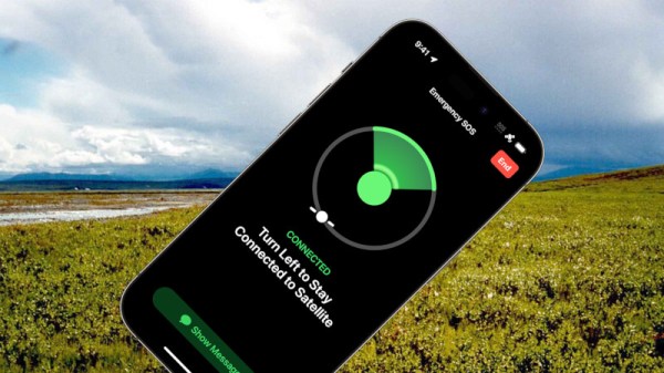
There is always some hype surrounding an Apple product announcement, and while maybe it’s not in the same league as those for the original iPod or iPhone, their iPhone 14 model will include emergency texting by satellite has generated quite a bit of coverage. It’s easy to find a lot about the system from the software end in terms of its interface and even Apple’s use of compression, but what about the radio side? Whose satellite constellation are they using, and how does it work?

As has been widely reported, their communication partner for the service is Globalstar, a provider of satellite data services that like their competitor Iridium have their origins in the 1990s when satellite phones were briefly seen as the Next Big Thing. They have a 24-satellite constellation, and they sell a range of off-the-grid voice, data, paging, tracking, and IoT connectivity services. The Apple emergency texting looks a lot like Globalstar’s Spot texting service. It’s only available in North America for now, we’re guessing because the satellites aren’t smart relays but straightforward transponders, and the network lacks sufficient ground station coverage outside that region.

With all the talk about low-earth-orbit connectivity surrounding services such as SpaceX’s Starlink it’s a bit unexpected to find ourselves back with a satellite constellation using 1990s technology. But we can see that as well as a major win for Globalstar as their service begins to look outdated by comparison to Starlink, it’s a perfect match for Apple in not requiring a complex ground station for low-bandwidth text messages. We expect that there will be some form of exclusivity in the deal, so it will be interesting to see how the larger Android vendors respond.

It’s worth noting, we’ve looked at satellite IoT services before.

Wilderness image: U.S. Fish and Wildlife Service, Public Domain.

Monitor Space Weather And The Atmosphere With Your Cellphone!

Above our heads, the atmosphere is a complex and unpredictable soup of gasses and charged particles subject to the influence of whatever the Sun throws at it. Attempting to understand it is not for the faint-hearted, so it has for centuries been the object of considerable research. A new project from the European Space Agency and ETH Zurich gives the general public the chance to participate in that research in a small way, by crowdsourcing atmospheric data gathering to a mobile phone app. How might a mobile phone observe the atmosphere? The answer lies in their global positioning receivers, which can track minute differences in the received signals caused by atmospheric conditions. By gathering as much of this data as possible, the ESA scientists will gain valuable insights into atmospheric conditions as they change across the globe.

The app requires an Android phone equipped with a dual frequency satnav receiver, and having been duly installed on the trusty Hackaday Motorola it in turn started picking up all the different constellations of satellites. The instructions are to leave it somewhere such as a windowsill with an unobstructed view of the sky and move it as little as possible, to which we’d add clicking the “Log in background” button and connectign a charger. There’s a promise that uploaders can win prizes, so aside from contributing to scientific discovery there might be an unexpected benefit. More details on the app can be found here, meanwhile many readers will know that this isn’t the only crowdsourced atmospheric data gathering effort.

Review: Hands On With The Swarm Satellite Network Eval Kit

If you have devices out in the field, you probably want to connect with them. There was a time when that was hard to do, requiring telephone wires or specialized radio gear. Now cellular data is prevalent, but even cellular isn’t everywhere. If you have the cash, you can pay a number of satellite companies to carry your data, but that’s generally pricey and has its own challenges.

The age of satellite constellations is changing that. Of course everyone by now has heard of Starlink which is offering satellite internet via numerous satellites that are much smaller than traditional telecom satellites. But they’re not the only came in town.

A company called Swarm has put up a constellation of 1/4U cube satellites in low orbits. They offer a ground station that uses an omni antenna and a subscription access program for small amounts of data. They sent us a unit to review, and while I haven’t used the system in a real project yet, the kit was pretty impressive.

About Swarm

Swarm tile device
The Swarm Tile is made to mount on a PCB

The Swarm “tile” is a tiny radio that can talk bi-directionally with small satellites in low Earth orbit. The little unit is made to mount on a PCB, can control its power consumption, and talks to your system via a standard 3.3V UART connection. It does, however, require a small antenna and maybe even a smaller antenna for its GPS module. Small, in this case, is about a mid-size handy talkie antenna. There is a half-wave antenna that doesn’t need a ground plane and a shorter antenna that does need a ground plane.

Continue reading “Review: Hands On With The Swarm Satellite Network Eval Kit”

Technical Audacity And The Phone Book

I often think we — or maybe the people who control our money — lack the audacity to take on really big projects. It is hard to imagine laying the transatlantic cable for the first time today, for example. When I want a good example of this effect, I usually say something like: “Can you imagine going to a boardroom of a major company today and saying, ‘We plan to run wire to every house and business in the world and connect them all together.'” Yet that’s what the phone company did. But it turns out, running copper wire everywhere was only one major challenge for the phone company. The other was printing phone directories. In today’s world, it is easy to imagine a computer system that keeps track of all the phone numbers that can spit out a printed version for duplication. But that’s a relatively recent innovation. How did big city phonebooks work before the advent of the computer?

Turns out, the Saturday Evening Post talked about how it all worked in a 1954 article. We aren’t sure there weren’t some computerized records by 1954, but the whole process was still largely manual. By that year, an estimated 60,000,000 directories went out each year in the United States alone. Some of these were small, but the Chicago directory — not including suburban directories — had over 2,100 pages. In New York City, the solution was to print a separate book for each borough. Even then. the Manhattan book was three inches thick and projected to grow to five inches by 1975.

Continue reading “Technical Audacity And The Phone Book”

Finding Dark Ships Via Satellite

It would seem that for as long as there have been ships on the ocean, there’s been smuggling. The International Maritime Organisation requires ships to have AIS, the automatic identification system which is akin to a transponder on an airplane. However, if you don’t want to be found, you often turn off your AIS. So how do governments and insurance companies track so-called dark ships? Using satellite technology. A recent post in Global Investigative Journal tells the story of how lower-cost satellites are helping track these dark ships.

Optical tracking is the obvious method, but satellites that can image ships can be expensive and have problems with things like clouds. Radar is another option, but — again — an expensive option if you aren’t a big military agency with money to spend. A company called HawkEye 360 uses smallsats to monitor ship’s RF emissions, which is much less expensive and resource-intensive than traditional methods. Although the data may still require correlation with other methods like optical sensing, it is still cost-effective compared to simply scanning the ocean for ships.

Continue reading “Finding Dark Ships Via Satellite”