Where’s The Cat? Locating Your Moggy Without Eating Batteries

Where the Hackaday Cat goes when she steps over the threshold into the wider world is a mystery, she reveals her whereabouts strictly on her terms and would we suspect be very cagey were we able to ask her about it. [Andy C] however has a need to know where his cat is spending her time, so he’s made a GPS collar for a bit of feline spying.

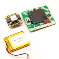
There are commercial GPS collars for pets, but they all share the flaw of extremely limited battery life. His challenge then was to create a collar that delivered the required pinpoint fix alongside a battery life measured in months. The solution was a combination of a low-power miniature GPS receiver and a low-power PC microcontroller hooked up to an FSK radio whose frequency he doesn’t give but which we suspect is probably the usual 433 MHz. The collar remains in low power mode until it receives a call on the FSK, at which point it wakes up, gets a GPS fix, transmits it, and returns to sleep.

The summary links to a series of posts which provide an extremely detailed look at all aspects of the project, and go well beyond mere GPS trackers for a cat. If you have an interest in low power devices or antenna matching for example, you’ll find a lot of interesting stuff in these pages. Of course, if all you need is a GPS tracker though, you may prefer a simpler option.

Fail Of The Week: How Not To Build Your Own DGPS Base Station

GPS is the modern answer to the ancient question about one’s place in the world yet it has its limitations. It depends on the time of flight of radio signals emitted by satellites twenty thousand kilometers above you. Like any system involving large distances and high velocities, this is bound to offer some challenges to precise measurements which result in a limit to achievable accuracy. In other words: The fact that GPS locations tend to be off by a few meters is rooted in the underlying principle of operation.

Today’s level of precision was virtually unattainable just decades ago, and we’re getting that precision with a handheld device in mere seconds. Incredible! Yet the goal posts continue to move and people are working to get rid of the remaining error. The solution is called Differential GPS or ‘DGPS’ and its concept looks surprisingly simple.

What’s fascinating is that you can use one GPS to precisely measure the error of another GPS. This is because the inherent error of a GPS fix is known to be locally constant. Two receivers next to each other pick up signals that have been affected in the same way and thus can be expected to calculate identical wrong positions. This holds true for distances up to several kilometers between individual receivers. So in order to remove the error, all you need is a GPS receiver in a known location to measure the current deviation and a way to transmit correction information to other units. DGPS does just that, using either terrestrial radio in some regions and satellites in others. Mobile solutions exist as well.

So a raspi with a USB GPS dongle in a known location should be able to act as a DGPS over IP base station, right? In theory, yes. In practice… fail.

Continue reading “Fail Of The Week: How Not To Build Your Own DGPS Base Station”

Handheld GPS Tracks All The Things

With a GPS on every smartphone, one would be forgiven for forgetting that handheld GPS units still exist. Seeking to keep accurate data on a few upcoming trips, [_Traveler] took on a custom-build that resulted in this GPS data logger.

Keeping tabs on [_Traveler] is a Ublox M8N GPS which is on full-time, logging data every 30 seconds, for up  to 2.5 days. All data is saved to an SD card, with an ESP32 to act as a brain and make downloading the info more accessible via WiFi . While tracking the obvious — like position, speed, and time — this data logger also displays temperature, elevation, dawn and dusk, on an ePaper screen which is a great choice for conserving battery.

The prototyping process is neat on this one. The first complete build used point-to-point soldering on a protoboard to link several breakout modules together. After that, a PCB design embraces the same modules, with a footprint for the ESP’s castellated edges and header footprints for USB charing board, SD card board, ePaper, etc. All of this finds a hope in a 3D printed enclosure. After a fair chunk of time coding in the Arduino IDE the logger is ready for [_Traveler]’s next excursion!

As far as power consumption in the field, [_Traveler] says the GPS takes a few moments to get a proper location — with the ESP chewing through battery life all the while — and plans to tinker with it in shorter order.

Not all GPS trackers are created equal: sometimes all you need is a stripped-down tracker for your jog, or to know exactly where every pothole is along your route.

[Via /r/electronics]

Opt-Out Fitness Data Sharing Leads To Massive Military Locations Leak

People who exercise with fitness trackers have a digital record of their workouts. They do it for a wide range of reasons, from gathering serious medical data to simply satisfying curiosity. When fitness data includes GPS coordinates, it raises personal privacy concerns. But even with individual data removed, such data was still informative enough to spill the beans on secretive facilities around the world.

Strava is a fitness tracking service that gathers data from several different brands of fitness tracker — think Fitbit. It gives athletes a social media experience built around their fitness data: track progress against personal goals and challenge friends to keep each other fit. As expected of companies with personal data, their privacy policy promised to keep personal data secret. In the same privacy policy, they also reserved the right to use the data shared by users in an “aggregated and de-identified” form, a common practice for social media companies. One such use was to plot the GPS data of all their users in a global heatmap. These visualizations use over 6 trillion data points and can be compiled into a fascinating gallery, but there’s a downside.

This past weekend, [Nathan Ruser] announced on Twitter that Strava’s heatmap also managed to highlight exercise activity by military/intelligence personnel around the world, including some suspected but unannounced facilities. More worryingly, some of the mapped paths imply patrol and supply routes, knowledge security officers would prefer not to be shared with the entire world.

This is an extraordinary blunder which very succinctly illustrates a folly of Internet of Things. Strava’s anonymized data sharing obsfucated individuals, but didn’t manage to do the same for groups of individuals… like the fitness-minded active duty military personnel whose workout habits are clearly defined on these heat maps. The biggest contributor (besides wearing a tracking device in general) to this situation is that the data sharing is enabled by default and must be opted-out:

“You can opt-out of contributing your anonymized public activity data to Strava Metro and the Heatmap by unchecking the box in this section.” —Strava Blog, July 2017

We’ve seen individual fitness trackers hacked and we’ve seen people tracked through controlled domains before, but the global scope of [Nathan]’s discovery puts it in an entirely different class.

[via Washington Post]

A Talking Clock For The 21st Century

The Talking Clock service is disappearing, and it’s quite possible that few of you will be aware of its passing. One of the staples of twentieth-century technology, the Talking Clock service was the only universally consumer-available source of accurate time information away from hourly radio time signals in the days before cheap radio-controlled clocks, or GPS. You’d dial (on a real dial, naturally!) a telephone number, to be greeted with a recorded voice telling you what the time would be at the following beep. Clocks were set, phone companies made a packet, and everybody was happy with their high-tech audio horology.

[Nick Sayer] used the USNO Master Clock telephone feed to see in the New Year, but had to make do with a voice from another time zone. It seems that there are no services remaining that provide one in Pacific time. His solution to the problem for a future year? Make his own Talking Clock, one that derives its time reference from GPS.

At its heart is a SkyTraq Venus838LPx miniature GPS module coupled to an ATMega32E5 microcontroller. The speech comes in the form of pre-recorded samples stored on an SD card. There is a small on-board amplifier to drive a single speaker. For extreme authenticity perhaps it could be attached to a GSM mobile phone module to provide a dial-up service, but he’s got everything he needs for a New Years Eve.

Want to hear what that that bit of nostalgia sounded like? Check out the quick clip below. As for modern replacements, we’ve had at least one talking clock here in the past, but not one using GPS.

Continue reading “A Talking Clock For The 21st Century”

Geocache Locator Is The Gift That Keeps On Giving

Depending on how you look at things, the holidays could be seen as either an excuse to spend money or an excuse to get creative. We imagine many Hackaday readers would rather head to their workbench than the mall when it comes time for gift giving, and [Sean Hodgins] is no different. He came up with the idea of hiding geocaches around his nephew’s neighborhood and building him a locator device to find them. The locator itself is intended to grow with his nephew, allowing him to reprogram it or use its parts for something completely different down the road.

The main components tucked inside of the 3D printed case of the locator are an Adafruit Trinket, a GPS receiver, and a compass module. The Adafruit NeoPixel Ring is of course front and center, serving as the device’s display. To power the device there’s an old battery, a LiPo charger circuit, and a 5V converter.

One of the goals for the project was that it could be constructed out of things [Sean] already had laying around, so some concessions had to be made. The Trinket ended up having too few pins, the compass lacks an accelerometer, and the switches and buttons are a bit clunky for the build. But in the end it comes together well enough to get the job done, and at least he was able to clear some stuff out of his parts bins.

To allow its owner to disassemble and potentially rebuild it into something else later, no soldered joints were used in the construction of the locator. Everything is done with jumper wires, which lead to some interesting problem solving such as using a strip of pin header as a bus bar of sorts. A bit of heat shrink over the bundle holds everything together and prevents shorts.

Location-aware gadgets happen to be an extremely popular gift choice among the hacker crowd. We’ve covered everything from devices cobbled together from trash to hardware which could pass for a commercial product.

Continue reading “Geocache Locator Is The Gift That Keeps On Giving”

Snail Is Actually Cleverly Strange Geocaching Waypoint

Basic geocaching consists of following GPS coordinates to a location, then finding a container which is concealed somewhere nearby. Like any activity, people tend to add their own twists to keep things interesting. [Jangeox] recently posted a video of the OLED Snail 2.0 to show off his most recent work. (This is a refinement of an earlier version, which he describes in a blog post.)

Another of [Jangeox]’s Electronic Waypoints
[Jangeox] spices up geocaching by creating electronic waypoints, and the OLED Snail is one of these. Instead of GPS coordinates sending someone directly to a goal, a person instead finds a waypoint that reveals another set of coordinates and these waypoints are followed like a trail of breadcrumbs.

A typical waypoint is an ATTINY85 microcontroller programmed to display an animated message on the OLED, and the message reveals the coordinates to the next waypoint. The waypoint is always cleverly hidden, and in the case of the OLED Snail 2.0 the enclosure is the shell of a large snail containing the electronics encased in resin. This means that the devices have a finite lifespan — the battery sealed inside is all the power the device gets. Fortunately, with the help of a tilt switch the electronics can remain dormant until someone picks it up to start the show. Other waypoints have included a fake plant, and the fake bolt shown here. Video of the OLED Snail 2.0 is embedded below.

Continue reading “Snail Is Actually Cleverly Strange Geocaching Waypoint”