You Can Get A Precision Instrument-Guided Landing Even In Antarctica

Traditional airports spend big money to install instrument landing systems (ILS) to guide planes in safely. In places like Antarctica, though, it’s simply not possible to permanently install a massive antenna array for localization, particularly with all the ice shifting about on the regular. As covered by Flightradar24, the solution to this is to use a transponder landing system (TLS) instead.
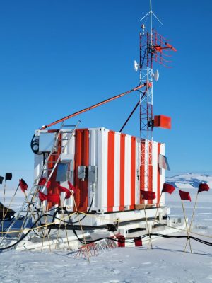
Comparatively compact! Credit: ANPC

A TLS tracks planes by using multilateration—basically, transponder signals are picked up by multiple antennas and the time delays are used to figure out the position of the aircraft. It then sends the guidance signals a plane would normally expect to receive from an ILS transmitter array, for horizontal and vertical guidance. These signals appear to the plane to be coming from antennas located as per a typical ILS array, with the TLS able to generate signals from ‘virtual emanation points” as needed. This allows the TLS to generate different landing approaches to suit different planes and conditions. From the pilot and aircraft side, it’s all perfectly transparent.

In Antarctica’s McMurdo station, landings are handled by a TLS system that barely takes up more space than a single shipping crate. The system can be set up in just a few hours, unlike a traditional ILS which takes significant installation work spanning weeks or months at best. At the moment, though, the landing strip at McMurdo is stable enough that the system only needs periodic realignment every three years or so.

You might assume that if you’re approaching Antarctica by plane, everything would be on manual. However, the creature comforts of modern airports are available even at one of the the most southerly airports on Earth!


Satellite Provides Detailed Data On Antarctic Ice

Ever since the first satellites started imaging the Earth, scientists have been using the data gathered to learn more about our planet and improve the lives of its inhabitants. From weather forecasting to improving crop yields, satellites have been put to work in a wide array of tasks. The data they gather can go beyond imaging as well. A new Chinese satellite known as Fengyun-3E is using some novel approaches to monitor Antarctic sea ice in order to help scientists better understand the changing climate at the poles.

While it is equipped with a number of other sensors, one of the more intriguing is a piece of equipment called WindRad which uses radar to measure wind at various locations and altitudes based on how the radar waves bounce off of the atmosphere at various places.  Scientists have also been able to use this sensor to monitor sea ice, and can use the data gathered to distinguish new sea ice from ice which is many years old, allowing them to better understand ice formation and loss at the poles. It’s also the first weather satellite to be placed in an early morning orbit, allowing it to use the long shadows cast by the sun on objects on Earth’s surface to gather more information than a satellite in other orbits might be able to.

With plenty of other imaging sensors on board and a polar orbit, it has other missions beyond monitoring sea ice. But the data that it gathers around Antarctica should give scientists more information to improve climate models and understand the behavior of sea ice at a deeper level. Weather data from satellites like these isn’t always confined to academia, though. Plenty of weather satellites broadcast their maps and data unencrypted on radio bands that anyone can access.

Hackaday Links Column Banner

Hackaday Links: December 24, 2023

Back near the beginning of the current Solar Cycle 25, we penned an article on what the whole deal is with solar cycles, and what could potentially lie in store for us as the eleven-year cycle of sunspot population developed. Although it doesn’t really come across in the article, we remember being somewhat pessimistic about things, thinking that Solar Cycle 25 would be somewhat of a bust in terms of increased solar activity, given that the new cycle was occurring along with other, longer-period cycles that tend to decrease solar output. Well, looks like we couldn’t have gotten that more wrong if we tried, since the Sun lashed out with a class X solar flare last week that really lit things up. The outburst came from a specific sunspot, number 3514, and clocked in at X2.8, the most powerful flare since just before the end of the previous solar cycle. To put that into perspective, X-class flares have a peak X-ray flux of 10-4 watts/m², which when you think about it is a lot of energy. The flare resulted in a strong radio blackout; pretty much everything below 30 MHz was unusable for a while.

Continue reading “Hackaday Links: December 24, 2023”

Making Electricity At The South Pole

In case you’ve ever wondered how the South Pole research stations are powered, then a recent blog post, South Pole Electrical Infrastructure by anonymous IT engineer [brr] is for you. Among the many issues covered, let’s look at how the electricity is made and, spoiler alert, how the specially formulated AN8 fuel blend is transported to the generators.

The main source of power is a trio of Caterpillar 3512B diesel generator sets, de-rated to 750 kW each due to the high altitude and the special fuel mixture. Unsurprisingly, all the fuel must be imported to Antarctica, a horribly inefficient endeavor. Fuel arrives initially at McMurdo Station harbor by tanker ship. From there, it can be sent to the Amundsen-Scott South Pole Station in one of two ways. The Lockheed LC-130 is a modified C-130 Hercules cargo plane developed in the 1950s specifically to support polar operations. It is the least efficient method, consuming 1.33 kg to transport 1 kg of fuel. Alternatively, fuel can be dragged by tractors via the South Pole Overland Traverse (SPoT), a 1600 km highway over compacted snow and ice. The trek takes about 40 days and only consumes 0.56 kg of fuel for every 1 kg, which is much better than air.

Continue reading “Making Electricity At The South Pole”

IGY: The Year We All Got Along

If you are a Steely Dan fan, you might know the Donald Fagen song, “IGY.” In it, Fagen sings about a rosy future with high-speed undersea rail, solar power, giant computers making life better, and spandex jackets. Since that song was on the 1982 album Nightfly, it is already too old for some people to remember, but the title goes back even further: the International Geophysical Year which was actually a little longer than a year in 1957 and 1958. The year was a concerted effort by 67 countries to further mankind’s knowledge of the Earth. It was successful,  and was big news in its day, although not much remembered now.

The real origin dates back to even earlier. In 1882 and 1932 there were International Polar Years dedicated to researching the polar regions of the Earth. In a way, it makes sense to do this. Why should 60 or more countries each mount difficult, dangerous, and expensive expeditions to such a hostile environment? However, instead of a third polar year, James Van Allen (who has a famous belt) and some other scientists felt that advances in many fields made it the right time to study geophysics. From the scientific point of view, the IGY coincided with the solar activity cycle maximum. But there were other forces at play, too.

Continue reading “IGY: The Year We All Got Along”

When Hams Helped Polar Researchers Come In From The Cold

We always enjoy [The History Guy] videos, although many of them aren’t much about technology. However, when he does cover tech topics, he does it well and his recent video on how ham radio operators assisted in operation Deep Freeze is a great example. You can watch the video, below.

The backdrop is the International Geophysical Year (IGY) where many nations cooperated to learn more about the Earth. In particular, from 1957 to 1958 there was a push to learn more about the last unexplored corner of our planet: Antarctica. Several of the permanent bases on the icy continent today were started during the IGY.

It’s hard for modern audiences to appreciate what the state of personal communication was in 1957. There were no cell phones and if you are thinking about satellites, don’t forget that Sputnik didn’t launch until late 1957, so that wasn’t going to happen, either.

Operation Deep Freeze had ten U. S. Navy vessels that brought scientists, planes, and Seabees (slang for members of the Naval Construction Batallion) — about 1,800 people in all over several years culminating in the IGY. Of course, the Navy had radio capabilities, but it wasn’t like the Navy to let you just call home to chat. Not to mention, a little more than 100 people were left for each winter and the Navy ships went home. That’s where ham radio operators came in.

Hams would do what is called a phone patch for the people stationed in Antarctica. Some hams also send radiograms to and from the crew’s families. One teen named Jules was especially dedicated to making connections to Antarctica. We can’t verify it, but one commenter says that Jules was so instrumental in connecting his father in Antarctica to his fiancee that when his parents married, Jules was their best man.

Jules and his brother dedicated themselves to keeping a morale pipeline from New Jersey to the frozen stations. He figures prominently in recollections of many of the written accounts from people who wintered at the nascent bases. Apparently, many of the men even traveled to New Jersey later to visit Jules. What happened to him? Watch the end of the video and you’ll find out.

While being a ham today doesn’t offer this kind of excitement, hams still contribute to science. Want to get in on the action? [Dan Maloney] can tell you how to get started on the cheap.

Continue reading “When Hams Helped Polar Researchers Come In From The Cold”

Jerri Nielsen: Surviving The Last Place On Earth

There may be no place on Earth less visited by humans than the South Pole. Despite a permanent research base with buildings clustered about the pole and active scientific programs, comparatively few people have made the arduous journey there. From October to February, up to 200 people may be stationed at the Amundsen-Scott South Pole Station for the Antarctic summer, and tourists checking an item off their bucket lists come and go. But by March, when the sun dips below the horizon for the next six months, almost everyone has cleared out, except for a couple of dozen “winter-overs” who settle in to maintain the station, carry on research, and survive the worst weather Mother Nature brews up anywhere on the planet.

To be a winter-over means accepting the fact that whatever happens, once that last plane leaves, you’re on your own for eight months. Such isolation and self-reliance require special people, and Dr. Jerri Nielsen was one who took the challenge. But as she and the other winter-overs watched the last plane leave the Pole in 1998 and prepared for the ritual first-night screening of John Carpenter’s The Thing, she had no way of knowing what she would have to do to survive the cancer that was even then growing inside her.

Continue reading “Jerri Nielsen: Surviving The Last Place On Earth”