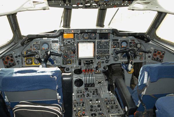
posted Sep 19th 2011 2:01pm by
Mike Szczys
filed under:
misc hacks

Take the risk of not recovering your hardware out of a near-space camera launch by streaming the data during flight. [Tim Zaman] is part of a team that developed the rig seen above. It sent 119 image back during the recent balloon launch. This included transmissions from as high as 36 kilometers.
The main hardware included a BeagleBoard with connected Webcam housed in a Styrofoam cooler for thermal protection. Pair that with a GPS module for location tracking, and a GPRS module for data transmission and you’re in business.
But that’s not all that went up. The team built a backup hardware module in case the primary failed. This one also had a GPS and GPRS radio, but was driven by an Arduino.
The radio connection made it easy to recover the hardware. GPS data led the team directly to the landing site. The package came to rest on the roof of a building, but we guess that’s more convenient than getting snagged at the top of a huge tree.
Don’t miss the hardware detail video that we’ve embedded after the break.
Read the rest of this entry »
posted Sep 16th 2011 10:11am by
Mike Nathan
filed under:
gps hacks

[Davy] and his friend [Chris] were tasked with putting together a bachelor party for their friend [J], and had a little more in mind than the standard drunken revelry. To earn the privilege of partying his brains out, they decided that [J] would have to fulfill a series of tasks and challenges before joining up with the rest of his friends for the evening’s events. [Davy] didn’t specify what these tasks were, lest he spoil the surprise, but he did let us in on a little device that he and [Chris] built to help guide the bachelor through his day.
They were a bit worried that the bachelor would get sidetracked during his journey if he happened to imbibe along the way, so they built a device called jGPX that would ensure [J] stayed on track and on time. jGPX is a custom GPS navigator consisting of an Arduino, a GPS module with built-in antenna, and a compass. The pair created a set of routes in Google Earth, exporting the data to KML for interpretation by their device. The jGPX is meant to guide [J] along via a small LCD screen that shows him the distance to his target as well as the proper direction of travel to get there.
It looks like [J’s] friends put a lot of effort into his party, and although there are no details as to how things went, we’re sure it was a blast!
posted Sep 6th 2011 2:28pm by
Brian Benchoff
filed under:
arduino hacks,
gps hacks,
portable audio hacks

The team at Eschelle Inconnue wanted to “trace a sound cartography of Islam” in Marseilles, France, so they came up with a clever little GPS walking tour powered by an Arduino, MP3 playback module, and a surface transducer speaker.
The team used a Processing app to define geographic areas where each MP3 file would play. An Arduino on the build queries a GPS module and selects the audio file from an MP3 playback module. This isn’t uncommon, and a lot of large outdoor museums (think battlefields) have similar setups.
Determining which audio to play at what location is fairly easy, but that’s not what makes this build special. Instead of simply hooking up a pair of headphones to the build, the team decided to use a surface speaker that turns just about any solid material into a speaker. From the writeup, this is supposed to, “diffuse sounds by giving the illusion to collect them, to listen to the words of the walls, the whisperings through the materials” but we think it’s just a great way to have several people listen to the same audio file at the same time.
posted Aug 11th 2011 1:48pm by
Mike Nathan
filed under:
gps hacks,
Microcontrollers

[Janis] has an outdoor cat that likes to roam all over the neighborhood. He was curious to see what he was up to all day, so he decided to build a small cat cam to document the feline’s comings and goings. After the cat returned one evening with a snail riding along on his back, [Janis] thought it would be pretty interesting to see where the cat was going as well.
He calls his creation “CatEye”, and it consists of a small JPEG color camera and GPS sensor, both of which are managed by what looks to be an ATMega328. The camera snaps pictures as the cat roams around, while the GPS sensor records its location throughout its travels. All of the data is stored on an SD card, making it easy to transfer the pics and .KML files back to his computer. A few clicks later, he can see everywhere his cat has been, using Google Earth.
It seems like a pretty interesting project, and we would love to see some schematics and code so that we can strap one of these on [Caleb] our cat to see where he’s been all day.
posted Aug 9th 2011 12:01pm by
Brian Benchoff
filed under:
digital cameras hacks,
misc hacks

[Greg Intermaggio] and [Shumit DasGupta] at Techsplosion launched a high altitude balloon last week that climbed to 90,000 feet above sea level somewhere over California. The play-by-play of the flight is one of the better stories we’ve seen on high altitude balloon builds.
The balloon, christened VGER-1, carried a SPOT satellite GPS messanger to send telemetry back to the ground. We’ve seen a few home brew balloon tracking devices, but [Greg] decided to use an off-the-shelf solution for the sake of simplicity. Like other balloons the VGER-1 carried a CanonPowershot camera with CHDK firmware.
Read the rest of this entry »
posted Jul 15th 2011 2:13pm by
Mike Nathan
filed under:
arduino hacks,
led hacks,
transportation hacks

Last year, when [Alex] was asked by his friend [Martin] to help him out with building some LED POV modules for a race car, his response was a enthusiastic “YES!”
[Martin’s] goal was to involve fans more deeply in the race, so he decided that the POV modules would carry messages from fans on-board, printing them in the night as the race cars screamed around the track. The pair started prototyping and testing a design, wrapping things up shortly before this year’s 24 hours of Nürburgring.
The modules consist of an Arduino-compatible AVR, a GPS module, a 16-LED light bar, and the circuitry for driving the LEDs. While most of the components are pretty standard fare, the we don’t often see a GPS sensor built into a POV display. [Alex] says that the sensor is used to calculate the speed of the cars, ensuring a uniform font size.
They took their LED displays to the 24 hours of Nürburgring, where they were invited by Audi to install the modules on a pair of R8 Le Mans race cars. As you can see by the pictures on his blog and Flickr set, the POV units worked out nicely without having to stretch the camera exposure times too far.
If you’ re interested to hear a bit more about how the displays were built, check out this entry in[Alex’s] blog, where he goes through some additional details.
Update:[Alex] pointed us to the videos!
posted Jul 5th 2011 2:46pm by
Mike Nathan
filed under:
gps hacks

Hackaday forum member [nes] was training for an endurance race, and rather than having someone verbally call out his lap times, he wanted something he could keep in-vehicle to help keep track of his performance. With the race budget running dry, he and his teammates needed something cheap, if not free, to get the job done.
He scored a “broken” GPS receiver on eBay for a measly £4 and found that the receiver worked, but corrupted software prevented the unit from mapping routes. Since he didn’t require routing functions to keep track of his lap times, he splayed the GPS receiver open and started hunting around for a serial bit stream. He found what he was looking for after a bit of probing and hooked it up to his computer to see if the data contained NMEA sentences.
He cut the receiver down to the necessary parts and then started work on the lap timer itself. The timer uses an ATMega32 to run the show, displaying relevant time and location information on an LCD panel he scavenged from the trash bin.
He admits that the wiring is a bit questionable, but says that after about seven hours of rough use, everything is still intact and working great.
posted Jun 14th 2011 4:05am by
Brian Benchoff
filed under:
cellphones hacks

Open Electronics just released a neat little board that can place you on a map without using GPS.
The board works on the basic principles of a cellphone network – the ‘cell’ network is a series of towers that are placed more or less equidistant to each other. Save for the most desolate parts of the country, a cell tower usually communicates with a phone one or two miles away. Usually, several cell towers can be seen, so the position of a cellphone can be pinpointed to within 200-350 feet. Translating cell towers to latitude and longitude is easily done by querying a Google database that was created for the mobile version of Google Maps.
The board itself is a PIC18 microcontroller and a SIM900 GSM module. The firmware available at Open Electronics is pretty impressive – all communication to the board is handled through SMS and the phone can report it’s location to 8 other phones.
It’s pretty impressive to think the same technology that caught [Kevin Mitnick] is now available to the masses. We’re wondering what Hack a Day readers would use this for, so if you have an idea leave a comment.