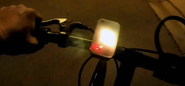
[Dan Julio] let us know about an exciting project that he and his team are working on at the Solid State Depot Makerspace in Boulder: the Solar Eclipse High Altitude Balloon. Weighing in at 1 kg and bristling with a variety of cameras, the balloon aims to catch whatever images are able to be had during the solar eclipse. The balloon’s position should be trackable on the web during its flight, and some downloaded images should be available as well. Links for all of that are available from the project’s page.
High altitude balloons are getting more common as a platform for gathering data and doing experiments; an embedded data recorder for balloons was even an entry for the 2016 Hackaday Prize.
If all goes well and the balloon is able to be recovered, better images and video will follow. If not, then at least a post-mortem of what the team thinks went wrong will be posted. Launch time in Wyoming is approximately 10:40 am Mountain Time (UTC -07:00) Mountain Daylight Time (UTC -06:00) on Aug 21 2017, so set your alarm!
How many times are you out on vacation and neglect to take pictures to document it all for the folks back at home? Or maybe you forgot just exactly where that awesome waterfall was. [Mark Williams] has made a Raspberry Pi Zero enabled cap that can take photos and geotag them with the location as well as the attitude of the camera.
The idea is to enable the reconstruction of a trip photographically. The hardware consists of a Raspberry Pi Zero W coupled with a Raspberry Camera V2 and a BerryGPS-IMU. Once activated, the system starts taking photos every two minutes. Within each photograph, the location of the photographer is recorded like most GPS enabled camera.
An additional set of data including yaw, pitch, and roll along with direction is also captured to understand where the camera is pointing when the image was taken. Even if he’s tilting his head at the time the photo was taken, the metadata allows it to be straightened out in software later.
This information is decoded using GeoSetter which puts the images on a map along with the field of view. Take a peek at the video below for the result of a trip around Sydney Harbour and the system in action. The Raspberry Pi Zero and camera combo are useful for a lot of things including this soldering microscope. Hopefully, we will be seeing some DIY VR gear with stereo cameras in the near future. Continue reading “The Perfect Tourist Techno-Cap”→
In May of 2000, then-President Bill Clinton signed a directive that would improve the accuracy of GPS for anyone. Before this switch was flipped, this ability was only available to the military. What followed was an onslaught of GPS devices most noticeable in everyday navigation systems. The large amount of new devices on the market also drove the price down to the point where almost anyone can build their own GPS tracking device from scratch.
The GPS tracker that [Vadim] created makes use not just of GPS, but of the GSM network as well. He uses a Neoway M590 GSM module for access to the cellular network and a NEO-6 GPS module. The cell network is used to send SMS messages that detail the location of the unit itself. Everything is controlled with an ATmega328P, and a lithium-ion battery and some capacitors round out the fully integrated build.
[Vadim] goes into great detail about how all of the modules operate, and has step-by-step instructions on their use that go beyond what one would typically find in a mundane datasheet. The pairing of the GSM and GPS modules seems to go match up well together, much like we have seen GPS and APRS pair for a similar purpose: tracking weather balloons.
Feel like taking a long walk, but can’t be bothered with carrying your drinks? Have no fear, this “Follow Me” Cooler Bot is here!
Really just a mobile platform with a cooler on top, the robot connects to smartphone via Bluetooth, following it using GPS. Making the platform involves a little woodworking skill, and an aluminium hub with a 3D-printed hub adapter connects the motors to a pair 6″ rubber wheels with a swivel caster mounted at the rear. A pocket in the platform’s base houses the electronics.
The Arduino Uno — via an L298n motor driver — controls two 12V DC, brushed and geared motors mounted with 3D printed brackets, while a Parallax PAM-7Q GPS Module in conjunction with an HMC 5883L compass help the robot keep its bearing. A duo of batteries power the motors and the electronics separately to prevent any malfunctions.
If you solemnly swear that you are up to no good, and you happen to spend most of your time in Manhattan below the mid-90s, then you will appreciate this Raspberry Pi-based Manhattan Marauder’s Map.
Not that a Harry Potter-themed map was necessarily [GawkyFuse]’s intention when creating this interesting build; it’s just that the old-time print of Manhattan — it shows Welfare Island in the East River, which was renamed Roosevelt Island in 1971 — lends a nice vintage feel to the build. Printed on plain paper, the map overlays a 64×32-LED matrix, which is driven by a matrix HAT riding atop the Pi 3.
[GawkyFuse] uses the OwnTracks app on his and his wife’s iPhone to report their locations back to CloudMQTT. The Pi subscribes to the broker and updates his location in red and her location in blue as they move about the city; a romantic touch is showing a single purple dot when they’re together. There’s no word on what’s displayed when either leaves the map area, but the 2048-pixel display offers a lot of possibilities.
We’ve seen a Weasley clock or two around these parts before, but strangely no Marauder’s Maps like this one. Although this Austrian tram-tracking map comes pretty close to [GawkyFuse]’s nice design.
It’s impossible to know when society began to manicure its front lawns. Truth be told — cutting the grass was, and still is a necessity. But keeping the weeds at bay, trimming, edging and so forth is not. Having a nice lawn has become a status symbol of modern suburbia all across the globe. When the aliens arrive, one of the first things they will surely notice is how nice our front lawns are. This feature of our civilization could have only been made possible with the advent of specialized grass-cutting machines.
It could be argued that the very first lawnmowers were live stock. The problem was they were quite high maintenance devices and tended to provide a very uneven cut, which did not bode well for families striving for the nicest front lawn on the dirt road. Coupled with the foul odor of their byproducts, the animals became quite unpopular and were gradually moved out of site into the back yards. Other solutions were sought to maintain the prestigious front yard.
The first mechanical lawnmower was invented in 1830 by a man named Edwin Budding, no doubt in an effort to one-up his neighbor, who still employed a Scythe. Budding’s mower looked much like today’s classic reel mowers, where a rotating cylinder houses the blades and rotates as the mower is pushed forward. Budding was granted a patent for his device by England, much to the dismay of his fellow neighbors — most of whom were forced to buy Budding’s mower due to the fact that everyone else in the neighborhood bought one, even though they weren’t actually needed.
By the early 1930’s, the cold war started by Budding and his neighbor had spread to almost every front yard on earth, with no end in sight. Fast forward to the modern era and the lawn and garden market did 10 billion in sales in 2014 alone. Technological advances have given rise to highly advanced grass-munching machines. For smaller yards, most use push mowers powered by a single cylinder IC engine. Many come with cloth bags to collect the clippings, even though everyone secretly hates using them because they gradually fill and make the mower heavier and therefore more difficult to push. But our neighbors use them, so we have to too. Larger yards require expensive riding mowers, many of which boast hydrostatic transmissions, which owners eagerly brag about at neighborhood get-togethers, even though they haven’t the slightest clue of what it actually is.
Us hackers are no different. We have front lawns just like everyone else. But unlike everyone else (including our neighbors) we have soldering irons. And we know how to use them. I propose we take a shot-across-the-bow and disrupt the neighborhood lawn war the same way Budding did 85 years ago. So break out your favorite microcontroller and let’s get to work!
High-altitude ballooning is becoming a popular activity for many universities, schools and hacker spaces. The balloons, which can climb up to 40 km in the stratosphere, usually have recovery parachutes to help get the payload, with its precious data, back to solid ground safely. But when you live in areas where the balloon is likely to be flying over the sea most of the time, recovery of the payload becomes tricky business. [Paul Clark] and his team from Durham University’s Centre for Advanced Instrumentation are working on building a small, autonomous glider – essentially a flying hard drive – to navigate from 30 km up in the stratosphere to a drop zone somewhere near a major road. An important element of such a system is the locator beacon to help find it. They have now shared their design for an “Iridium 9603 Beacon” — a small Arduino-compatible unit which can transmit its location and other data from anywhere via the Iridium satellite network.
The beacon uses the Short Burst Data service which sends email to a designated mail box with its date, time, location, altitude, speed, heading, temperature, pressure and battery voltage. To do all of this, it incorporates a SAMD21G18 M0 processor; FGPMMOPA6H GPS module; MPL3115A2 altitude sensor; Iridium 9603 Short Burst Data module + antenna and an LTC3225 supercapacitor charger. Including the batteries and antenna, the whole thing weighs in at 72.6 g, making it perfectly suited for high altitude ballooning. The whole package is powered by three ‘AAA’ Energizer Ultimate Lithium batteries which ought to be able to withstand the -56° C encountered during the flight. The supercapacitors are required to provide the high current needed when the beacon transmits data.
The team have tested individual components up to 35 km on a balloon flight from NASA’s Columbia Scientific Balloon Facility and the first production unit will be flown on a much smaller balloon, launched from the UK around Christmas. The GitHub repository contains detailed information about the project along with the EagleCAD hardware files and the Arduino code. Now, if only Santa carried this on his Sleigh, it would be easy for NORAD to track his progress in real time.