Google Maps, Now On The NES

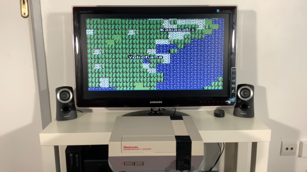
Many years ago, Google created one of its famous April Fools jokes suggesting it would make an 8-bit version of Google Maps for the original Nintendo Entertainment System. [ciciplusplus] decided it needed to become a reality, however, and set to work. (Video, embedded below.)

It’s a suitably blocky, low-resolution implementation, but it nevertheless is a mapping app running on an NES. Zooming in and out is via the A and B buttons, while the D-pad is used to scroll. Country and city labels are rendered on the map in the relevant areas in a charming old-school font.

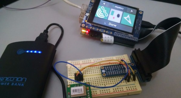
The project uses a Raspberry Pi 3A+ and a Cypress Semiconductor FX2LP microcontroller, which fits inside a NES cartridge. It works the same way as the earlier NES Doom project which uses the Raspberry Pi to feed data to the NES’s Picture Processing Unit. It’s achieved with a simple bit of code burned on a ROM inside the cartridge, which boots up the NES and primes it to receive data from the Raspberry Pi via the FX2LP.

In current form, it’s not capable of doing much more than allowing the user to scroll around and zoom in on parts of the map. We’d love to see a fully-fledged version that could deliver driving directions or similar, however. If you end up achieving such a feat, be sure to let us know. Continue reading “Google Maps, Now On The NES”

Travel Globe Spins You Around Memory Lane

We all have our own preferences when it comes to travel souvenirs — that little something that brings back the memories and feelings of a past holiday every time we look at it, whether it’s the cliché fridge magnet, some local speciality, or just the collection of photos we took. But then there are those journeys that can’t be summarized into a single item and may require a bit more creativity. For [Jonathan], it was last year’s trip around the world that took him and [Maria] to locations all over Europe, Asia, and Oceania, and he found a great way to remember it: an interactive, laser-cut travel globe displaying all the places they went to.

Building a sphere is of course a bit tricky with a laser cutter, so [Jonathan] went for the icosahedron shaped Dymaxion map projection (think of a large d20 dice) and burnt the world onto it. Inside the globe is an ESP8266, an MPU-6050 IMU, and a bunch of LEDs to light up the travel locations using the WLED library. Taking the data from the IMU, he customized the WLED library to determine which way the globe is positioned, and highlights the top-facing location in a different color.

While that would already make a nice souvenir on its own, [Jonathan] didn’t stop here. Using Google’s My Maps service, which lets you create custom maps with own points of interest and have for example photos attached to them, the ESP8266 hosts the travel map also as a web page. Feeding the IMU data to the JavaScript code that’s handling the map API, the globe itself now doubles as an input device to control the virtual map. So whenever the globe is physically rotated to highlight a certain location, the web page’s map is focused to that same location and shows randomly the pictures they have taken there. Check out the video below to see it all in action.

This is a great way to reminisce about a memorable journey even years down the road, and while it may not be flexible to extend, it seems like the kind of trip that deserves a standalone device anyway. Plus, the Dymaxion map is definitely an interesting projection — so here’a a foldable one, just because. And If you like tracking things on a globe, here’s one that shows the location of the ISS.

Continue reading “Travel Globe Spins You Around Memory Lane”

How Many Smartphones Does It Take To Make A Traffic Jam?

Online mapping services pack in a lot of functionality that their paper-based forebearers could simply never imagine. Adding in metadata for local landmarks, businesses and respective reviews, and even live traffic data, they have the capability to deliver more information than ever before – and also correspondingly, shape human behaviour. [Simon Weckert] decided to explore this concept with a cheeky little hack.

Pictured: All it takes to create a traffic jam on Google Maps!

The hack targets the manner in which Google collects live traffic data for display on Google Maps. When users load the app, Google takes location data from individual phones, tracking them as they travel along roadways. Large numbers of users travelling slowly down a road indicate there’s heavy traffic, and thus Google will display corresponding warnings on their maps and redirect users to take alternative paths.

To pull off the hack, [Simon] placed 99 smartphones in a handy-cart, tugging them behind him as he walked slowly down a series of streets. In the video, this is overlaid with Google’s map data captured at the time. The app updates the maps with orange and red lines down the roads which [Simon] travelled with his 99 pretend drivers, indicating a traffic jam.

We’d love to know whether [Simon] ran 99 individual SIM cards with data access, or if the hack was perpetrated with the use of a WiFi hotspot for cheaper internet access. Reddit comments note that Google will likely swiftly work on methods to prevent such tomfoolery in future. It’s simple to see that 99 individual users reporting the exact same location and speed at the same time would be trivial to filter out from traffic monitoring in future.

It’s both a commentary on the power we give these apps in our lives, as well as a great demonstration of how easily such systems can be trifled with. We first reported on Google’s traffic monitoring back in 2009, when it was a technology in its infancy. Video after the break.

Continue reading “How Many Smartphones Does It Take To Make A Traffic Jam?”

Location Sharing With Google Home

With Google’s near-monopoly on the internet, it can be difficult to get around in cyberspace without encountering at least some aspect of this monolithic, data-gathering giant. It usually takes a concerted effort, but it is technically possible to do. While [Mat] is still using some Google products, he has at least figured out a way to get Google Home to work with location data without actually sharing that data with Google, which is a step in the right direction.

[Mat]’s goal was to use Google’s location sharing features through Google Home, but without the creepiness factor of Google knowing everything about his life, and also without the hassle of having to use Google Maps. He’s using a few things to pull this off, including a NodeRED server running on a Raspberry Pi Zero, a free account from If This Then That (IFTTT), Tasker with AutoRemote plugin, and the Google Maps API key. With all of that put together, and some configuration of IFTTT he can ask his Google assistant (or Google Home) for location data, all without sharing that data with Google.

This project is a great implementation of Google’s tools and a powerful use of IFTTT. And, as a bonus, it gets around some of the creepiness factor that Google tends to incorporate in their quest to know all the data.

Continue reading “Location Sharing With Google Home”

Mapillary For The Raspberry Pi

If you live out in the boondocks, out of reach from the Google Maps car, you might have noticed there aren’t too many pictures of your area on the Internet. Mapillary is hoping to change that with crowdsourced photos of the entire planet, with mobile apps that snap a pic and upload it to the web. [sabas1080] is bringing this capability to the most popular ARM dev board out there, the Raspberry Pi.

The Raspberry Pi is not a phone, the usual way to upload pics to Mapillary. There’s no GPS, so geotagging is out of the question. The Pi doesn’t have a camera or a screen, and if you’re taking pictures of remote locations, a battery would be a good idea.

All these pieces are available for the Pi, though; [sabas1080] sourced a display from Adafruit, the camera is a standard Raspi affair, and the GPS is a GY-NEO6MV2 module from the one of the numerous Chinese retailers. Add a big power bank battery, and all the hardware is there.

The software is where this build gets tricky. Mapillary has a nice set of free tools written in Python, no less, but this is only part of the build. [sabas1080] needed to connect the camera, set up the display, and figure out how to make everything work with the Mapillary tools. In the end, [sabas] was able to get the entire setup working as a programmable, mobile photo booth.

Bike Cross Country In Your Basement With Google Streetview

Biking cross-country is a worthwhile pursuit, but then you’ll have to deal with terrible drivers, rain, bugs, and heat. [Jeff Adkins] over at lowendmac has a neat solution to exploring the country via bicycle without ever leaving the safety and air conditioning of your basement.

For his build, [Jeff] used a magnetic reed switch attached to the frame of his stationary bike and the pedal crank. Whenever the pedal crank is turned, a reed switch closes on every revolution. This reed switch is connected to a new Arduino Leonardo programmed to transmit keyboard presses to a computer for every five revolutions of the pedal. From there, it’s a simple matter of loading up Google Streetview on a laptop and letting the Arduino automatically advance through Streetview images while pedaling.

The next part of [Jeff]’s project will be adding left and right buttons to his stationary bike to navigate Google Streetview images without taking his hands off the handlebars. You can check out a demo of [Jeff] cruising around after the break.

via reddit

Continue reading “Bike Cross Country In Your Basement With Google Streetview”

Location Recorder And Mapper

[Jeroen’s] student project is a module that uses GPS tracking to create travel data on Google maps. It’s not really a spy device as the data isn’t transmitted, but would be a lot of fun to use on cycling and hiking adventures. A PIC 18F2550 reads location and altitude data from a GPS receiver as well as data from an accelerometer. This information can be displayed on an attached touchscreen display and it is also saved to a pair of EEPROMs. When you get back from your trip, the data pulled from the device via a serial connection is processed by [Jeroen’s] C# application and used to overlay the route on a google map. He’s got a source code package available for download but we’ve saved you the trouble if the schematic is all you’re after. It’s attached after the break.

Continue reading “Location Recorder And Mapper”