Amateur Astronomer Images Spy Satellite

As anyone who’s looked at the sky just before dawn or right after dusk can confirm, for the last seventy years or so there have been all kinds of artificial satellites floating around in low-Earth orbit that are visible to the naked eye. Perhaps the most famous in the last few decades is the International Space Station, but there are all kinds of others up there from amateur radio satellites, the Starlink constellation, satellite TV, and, of course, various spy satellites from a few of the world’s governments. [Felix] seems to have found one and his images of it can be found here.

[Felix] has been taking pictures of the night sky for a while now, including many different satellites. While plenty of satellites publish their paths to enable use, spy satellites aren’t generally public record but are still able to be located nonetheless. He uses a large Dobsonian telescope to resolve the images of several different satellites speculated to be spy satellites, with at least one hosting a synthetic aperture radar (SAR) system. His images are good enough to deduce the size and shape of the antennas used, as well as the size of the solar panels on board.

As far as being concerned about the ramifications of imaging top-secret technology, [Felix] is not too concerned. He states that it’s likely that most rival governments would be able to observe these satellites with much more powerful telescopes that he has, so nothing he has published so far is likely to be a surprise to anyone. Besides, these aren’t exactly hidden away, either; they’re up in the sky for anyone to see. If you want to take a shot at that yourself you can get a Dobsonian-like telescope mostly from parts at Ikea, and use a bit of off-the-shelf electronics to point them at just the right position too.

Rediscovering The Nile: The Ancient River That Was Once Overlooked By The Egyptian Pyramids

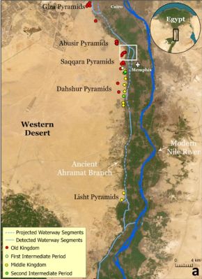
Although we usually imagine the conditions in Ancient Egypt to be much like the Egypt of today, back during the Holocene there was significantly more rain as a result of the African Humid Period (AHP). This translated in the river Nile stretching far beyond its current range, with many more branches. This knowledge led a team of researchers to test the hypothesis that the largest cluster of pyramids in the Nile Valley was sited along one of these now long since vanished branches. Their findings are described in an article published in Communications Earth & Environment, by [Eman Ghoneim] and colleagues.

The Ahramat Branch and pyramids along its trajectory. (Credit: Eman Ghoneim et al., 2024)

The CliffsNotes version can be found in the accompanying press release by the University of North Carolina Wilmington. Effectively, the researchers postulated that a branch of the Nile existed along these grouping of pyramids, with their accompanying temples originally positioned alongside this branch. The trick was to prove that a river branch once existed in that area many thousands of years ago.

What complicates this is that the main course of the Nile has shifted over the centuries, and anthropogenic activity has obscured much what remained, making life for researchers exceedingly difficult. Ultimately a combination of soil core samples, geophysical evidence, and remote sensing (e.g. satellite imagery) helped to cement the evidence for the existence what they termed the Ahramat Nile Branch, with ‘ahramat’ meaning ‘pyramids’ in Arabic.

Synthetic Aperture Radar (SAR) and high-resolution radar elevation data provided evidence for the Nile once having traveled right past this string of pyramids, also identifying the modern Bahr el-Libeini canal as one of the last remnants of the Ahramat Branch before the river’s course across the floodplain shifted towards the East, probably due to tectonic activity. Further research using Ground Penetrating Radar (GPR) and Electromagnetic Tomography (EMT) along a 1.2 km section of the suspected former riverbed gave clear indications of a well-preserved river channel, with the expected silt and sediments.

Soil cores to a depth of 20 and 13 meters further confirmed this, showing not only the sediment, but also freshwater mussel shells at 6 meter depth. Shallow groundwater was indicated at these core sites, meaning that even today subsurface water still flows through this part of the floodplain.

These findings not only align with the string of pyramids and their causeways that would have provided direct access to the water’s edge, but also provided hints for a further discovery regarding the Bent Pyramid — as it’s commonly known — which is located deep inside the desert today. Although located far from the floodplain by about a kilometer, its approximately 700 meters long causeway terminates at what would have been a now extinct channel: the Dahshur Inlet, which might also have served the Red Pyramid and others, although evidence for this is shakier.

Altogether, these findings further illustrate an Ancient Egypt where the Old Kingdom was followed by a period of severe changes, with increasing drought caused by the end of the AHP, an eastwardly migrating floodplain and decreased flow in the Nile from its tributaries. By the time that European explorers laid eyes on the ancient wonders of the Ancient Egyptian pyramids, the civilization that had birthed them was no more, nor was the green and relatively lush environment that had once surrounded it.

You Can Find Military Radars On Publicly-Available Satellite Data

When it comes to hunting down military radar installations and associated hardware, we typically think of equipment that is firmly in the price bracket of nation states and their military forces. Whether it’s early warning radar, those used for air defence, or for naval purposes, you’d think it was relatively difficult to intercept or track these emissions.

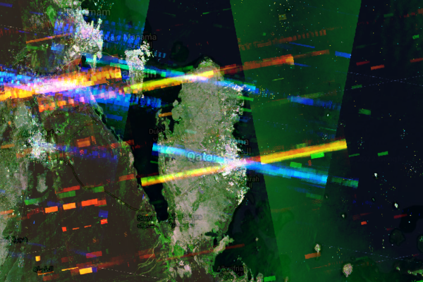
However, a new tool built by geocomputation lecturer Ollie Ballinger shows this isn’t the case. In fact, openly-available data captured via satellite can be used to find all manner of military radar emitters. Let’s explore how!

Continue reading “You Can Find Military Radars On Publicly-Available Satellite Data”

Finding Dark Ships Via Satellite

It would seem that for as long as there have been ships on the ocean, there’s been smuggling. The International Maritime Organisation requires ships to have AIS, the automatic identification system which is akin to a transponder on an airplane. However, if you don’t want to be found, you often turn off your AIS. So how do governments and insurance companies track so-called dark ships? Using satellite technology. A recent post in Global Investigative Journal tells the story of how lower-cost satellites are helping track these dark ships.

Optical tracking is the obvious method, but satellites that can image ships can be expensive and have problems with things like clouds. Radar is another option, but — again — an expensive option if you aren’t a big military agency with money to spend. A company called HawkEye 360 uses smallsats to monitor ship’s RF emissions, which is much less expensive and resource-intensive than traditional methods. Although the data may still require correlation with other methods like optical sensing, it is still cost-effective compared to simply scanning the ocean for ships.

Continue reading “Finding Dark Ships Via Satellite”

Watching The Watchers: The State Of Space Surveillance

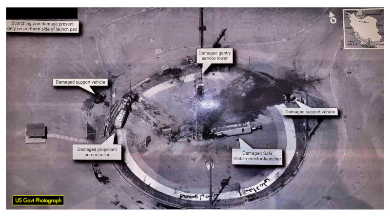
By now you’ve almost certainly heard about the recent release of a high-resolution satellite image showing the aftermath of Iran’s failed attempt to launch their Safir liquid fuel rocket. The geopolitical ramifications of Iran developing this type of ballistic missile technology is certainly a newsworthy story in its own right, but in this case, there’s been far more interest in how the picture was taken. Given known variables such as the time and date of the incident and the location of the launch pad, analysts have determined it was likely taken by a classified American KH-11 satellite.

The image is certainly striking, showing a level of detail that far exceeds what’s available through any of the space observation services we as civilians have access to. Estimated to have been taken from a distance of approximately 382 km, the image appears to have a resolution of at least ten centimeters per pixel. Given that the orbit of the satellite in question dips as low as 270 km on its closest approach to the Earth’s surface, it’s likely that the maximum resolution is even higher.

Of course, there are many aspects of the KH-11 satellites that remain highly classified, especially in regards to the latest hardware revisions. But their existence and general design has been common knowledge for decades. Images taken from earlier generation KH-11 satellites were leaked or otherwise released in the 1980s and 1990s, and while the Iranian image is certainly of a higher fidelity, this is not wholly surprising given the intervening decades.

What we know far less about are the orbital surveillance assets that supersede the KH-11. The satellite that took this image, known by its designation USA 224, has been in orbit since 2011. The National Reconnaissance Office (NRO) has launched a number of newer spacecraft since then, with several more slated to be lifted into orbit between now and 2021.

So let’s take a closer look at the KH-11 series of reconnaissance satellites, and compare that to what we can piece together about the next generation or orbital espionage technology that’s already circling overhead might be capable of.

Continue reading “Watching The Watchers: The State Of Space Surveillance”

Bike-Mounted Synthetic-Aperture Radar Makes Detailed Images

Synthetic-aperture radar, in which a moving radar is used to simulate a very large antenna and obtain high-resolution images, is typically not the stuff of hobbyists. Nobody told that to [Henrik Forstén], though, and so we’ve got this bicycle-mounted synthetic-aperture radar project to marvel over as a result.

Neither the electronics nor the math involved in making SAR work is trivial, so [Henrik]’s comprehensive write-up is invaluable to understanding what’s going on. First step: build a 6-GHz frequency modulated-continuous wave (FMCW) radar, a project that [Henrik] undertook some time back that really knocked our socks off. His FMCW set is good enough to resolve human-scale objects at about 100 meters.

Moving the radar and capturing data along a path are the next steps and are pretty simple, but figuring out what to do with the data is anything but. [Henrik] goes into great detail about the SAR algorithm he used, called Omega-K, a routine that makes use of the Fast Fourier Transform which he implemented for a GPU using Tensor Flow. We usually see that for neural net applications, but the code turned out remarkably detailed 2D scans of a parking lot he rode through with the bike-mounted radar. [Henrik] added an auto-focus routine as well, and you can clearly see each parked car, light pole, and distant building within range of the radar.

We find it pretty amazing what [Henrik] was able to accomplish with relatively low-budget equipment. Synthetic-aperture radar has a lot of applications, and we’d love to see this refined and developed further.

[via r/electronics]

An Improvised Synthetic Aperture Radar

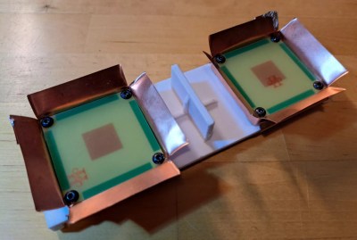
[Henrik] is at it again. Another thoroughly detailed radar project has shown up on his blog. This time [Henrik] is making some significant improvements to his previous homemade radar with the addition of Synthetic Aperture Radar (SAR) to his previous Frequency Modulated Continuous Wave (FMCW) system.

[Henrik’s] new design uses an NXP LPC4320 which uniquely combines an ARM Cortex-M4 MCU along with a Cortex-M0 co-processor. The HackRF also uses this micro as it has some specific features that can be taken advantage of here like the Serial GPIO (SGPIO) which can be tediously configured and high-speed USB all for ~$8 in single quantity. The mixed signal design is done in two boards, a 4 layer RF board and 2 layer digital board.

Like the gentleman he is, [Henrik] has included schematics, board files, and his modified source from the HackRF project in his github repo. There is simply too much information in his post to attempt to summarize here, if you need instant gratification check out the pictures after the break.

The write-up on his personal blog is impressive and worth look if you didn’t catch our coverage of his single board Linux computer, or his previous radar design.

Continue reading “An Improvised Synthetic Aperture Radar”