[Aerotenna] recently announced the first successful flight of an unmanned air vehicle (UAV) powered by a Xilinx Zynq processor running ArduPilot. The Zynq is a dual ARM processor with an onboard FPGA that can offload the processor or provide custom I/O devices. They plan to release their code to their OcPoC (Octagonal Pilot on a Chip) project, an open source initiative that partners with Dronecode, an open source UAV platform.
uav97 Articles
Hackaday Prize Entry: Tracking Rhinos With UAVs
For his Hackaday Prize project, [tlankford01] is using RC planes and UAVs as an anti-poaching system for rhinos and elephants. It’s a laudable goal for sure, but the conditions of this use case make for some very interesting engineering challenges.
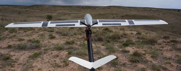
The design goals [tlandford] has set are relatively simple for a bush plane, but building a plane that can fly 200km with a 6kg payload and return to base is a challenge that isn’t usually taken up by RC enthusiasts. For this project, [tlandford] is using an entirely 3D printed airframe, with living hinges printed right into the control surfaces. That in itself is pushing the limits of amateur airframes, but [tlandford] isn’t stopping there.
This UAV system will be completely automated, with a single ground control system taking care of controlling a swarm of planes, pointing a tracking antenna, and connecting to the Internet for observation or control from anywhere in the world.
The project that has seen a lot of improvement since it was entered in last year’s Hackaday Prize. The addition of a completely 3D printed airframe is a big one, and replacing the RVJet with something that looks a bit more like a glider should increase the loiter times over the target. There’s a video of the Icarus flying available below. If you also have a UAV project entered in The Hackaday Prize, there is now one obvious choice of what music you should use.
Continue reading “Hackaday Prize Entry: Tracking Rhinos With UAVs”
Ducted Fan Drone Flies
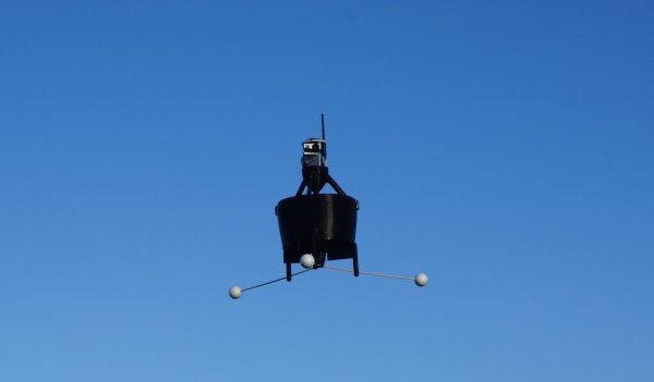
A while back, we wrote about the ducted fan, single rotor, VTOL drone that [Armin Strobel] was working on. It wasn’t quite finished then, and hadn’t got off the ground yet. He’s posted an update, and from the looks of it, he’s made tons of progress, including a first flight with successful take-off and landing.
The successful flight was no coincidence. Tuning any kind of ‘copter is a tricky business. Handling them manually during testing could be outright dangerous. So he built two different test-beds from pieces of wood, some 3D printed parts and bearings. One lets him mount the drone and tune its pitch (and roll), while the other lets him tune the yaw parameters. And just like they do in wind tunnel testing, he fixed short pieces of yarn at various points on the air frame to check for turbulence. Doing this also gave him some insight into how he could improve the 3D printed air-frame in the next iteration. He repeated the tests on the two test beds, going back and forth to make sure the tuning parameters were not interfering with each other. He also modified the landing gear to improve stability during take-off and landing and to prevent tipping. [Armin] is using the PixHawk PX4 for flight control and a BeagleBone Black for higher level functions and control.
Once the first flight showed that the drone could do stable flight, he attached a Go-Pro and recorded some nice video on subsequent flights. The next steps are to fine tune the flight control parameters to ensure stable hovering with position hold and way point following. He may also 3D print an improved air-frame. For details about the build, check out our earlier blog post on the Ducted Fan Drone. Check out the two videos below – one showing the first flight of the Drone, and the other one about the test beds being used for tuning.
Ducted Fan Drone Uses 1 Rotor For VTOL
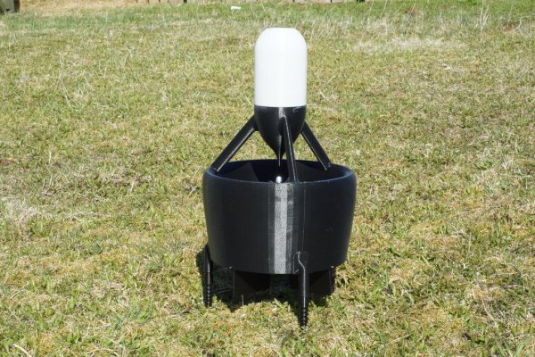
Multi-rotor fixed-pitch aircraft – quad, hexa, octa copters – are the current flavor of the season with hobby and amateur flight enthusiasts. The serious aero-modeling folks prefer their variable-pitch, single rotor heli’s. Defense and military folks, on the other hand, opt for a fixed wing UAV design that needs a launch mechanism to get airborne. A different approach to flight is the ducted fan, vertical take-off and landing UAV. [Armin Strobel] has been working on just such a design since 2001. However, it wasn’t until recent advances in rapid-prototyping such as 3D printing and availability of small, powerful and cheap flight controllers that allowed him to make some progress. His Ducted Fan VTOL UAV uses just such recent technologies.
Ducted fan designs can use either swivelling tilt rotors that allow the craft to transition from vertical flight to horizontal, or movable control surfaces to control thrust. The advantage is that a single propeller can be used if the model is not too big. This, in turn, allows the use of internal combustion engines which cannot be used in multi-rotor craft (well, they’ve proven difficult to use thus far).
[Armin] started this project in 2001 in a configuration where the centre of gravity is located beneath trust vectoring, giving the advantage of stability. Since there were no hobby autopilots available at the time, it was only equipped with one gyroscope and a mechanical mixer to control the vehicle around the vertical axis. Unfortunately, the craft was destroyed during the first flight, after having managed a short flight, and he stopped further work on it – until now. To start with, he built his own 3D printer – a delta design with a big build volume of 400mm3. 3D printing allowed him to build a structure which already included all the necessary mount points and supports needed to fix servos and other components. The in-fill feature allowed him to make his structure stiff and lightweight too.
Intending to build his own auto-pilot, he experimented with a BeagleBone Black connected to a micro controller to interface with the sensors and actuators. But he wasn’t too happy with initial results, and instead opted to use the PixHawk PX4 auto-pilot system. The UAV is powered by one 3-cell 3500mAh LiPo. The outside diameter of the duct is 30cm (12”), the height is 55cm (22”) and the take-off weight is about 1.2kg (2.6 pound). It has not yet been flown, since he is still waiting for the electronics to arrive, but some bench tests have been conducted with satisfactory results. In the meantime, he is looking to team up with people who share similar interests, so do get in touch with him if this is something up your alley.
If you want to look at other interesting designs, check this UAV that can autonomously transition from quadcopter flight to that of a fixed-wing aircraft or this VTOL airplane / quadcopter mashup.
Hackaday Links: May 24, 2015
A few months ago, we heard about a random guy finding injection molds for old Commodore computers. He did what the best of us would do and started a Kickstarter to remanufacture these cool old cases. It’s the best story on retrocomputing this year, and someone else figured out they could remanufacture Commodore 64 keycaps. If you got one of these remanufactured cases, give the keycaps a look.
Remember this Android app that will tell you the value of resistors by reading their color code. Another option for the iOS crowd was presented at Maker Faire last weekend. It’s called ResistorVision, and it’s perfect for the colorblind people out there. An Android version of ResistorVision will be released sometime in the near future.
A few folks at Langly Research Center have a very cool job. They built a hybrid electric tilt wing plane with eight motors on the wing and two on the tail. It’s ultimately powered by two 8 hp diesel engines that charge Liion batteries. When it comes to hydrocarbon-powered hovering behemoths, our heart is with Goliath.
A bottom-of-the-line avionics panel for a small private plane costs about $10,000. How do you reduce the cost? Getting rid of FAA certification? Yeah. And by putting a Raspberry Pi in it. It was expoed last month at the Sun ‘N Fun in Florida, and it’s exactly what the pilots out there would expect: a flight system running on a Raspberry Pi. It was installed in a Zenith 750, a 2-seat LSA, registered as an experimental. You can put just about anything in the cabin of one of these, and the FAA is okay with it. If it’ll ever be certified is anyone’s guess.
Hackaday Links: May 17, 2015
Here’s a worthwhile Kickstarter for once: the Prishtina Hackerspace. Yes, that’s a Kickstarter for a hackerspace in Kosovo. Unlike most hackerspace Kickstarters, they’re already mostly funded, with 20 days to go. If we ever get around to doing the Istanbul to Kaliningrad hackerspace tour, we’ll drop by.
Codebender is a web-based tool that allows you to code and program an Arduino. The Chromebook is a web-based laptop that is popular with a few schools. Now you can uses Codebender on a Chromebook. You might need to update your Chromebook to v42, and there’s a slight bug in the USB programmers, but that should be fixed in a month or so.
Here’s a great way to waste five minutes. It’s called agar.io. It’s a multiplayer online game where you’re a cell, you eat dots that are smaller than you, and bigger cells (other players) can eat you. [Morris] found the missing feature: being able to find the IP of a server so you can play with your friends. This feature is now implemented in a browser script. Here’s the repo.
The FAA currently deciding the fate of unmanned aerial vehicles and systems, and we’re going to live with any screwup they make for the next 50 years. It would be nice if all UAV operators, drone pilots, and everyone involved with flying robots could get together and hash out what the ideal rules would be. That’s happening in late July thanks to the Silicon Valley Chapter of AUVSI (Association for Unmanned Vehicle Systems International).
SOLAR ROADWAYS!! Al Jazeera is reporting a project in the Netherlands that puts solar cells in a road. It’s just a bike path, it’s only 70 meters long, and it can support at least 12 tonnes (in the form of a ‘fire brigade truck’). There’s no plans for the truly dumb solar roadways stuff – heating the roads, or having lanes with LEDs. We’re desperately seeking more information on this one.
Hackaday Prize Entry: Multispectral Imaging For A UAV
At least part of the modern agricultural revolution that is now keeping a few billion people from starving to death can be attributed to remote sensing of fields and crops. Images from Landsat and other earth imaging satellites have been used by farmers and anyone interested in agriculture policy for forty years now, and these strange, false-color pictures are an invaluable resource for keeping the world’s population fed.
The temporal resolution of these satellites is poor, however; it may be a few weeks before an area can be imaged a second time. For some uses, that might be enough.
For his Hackaday Prize entry (and his university thesis), [David] is working on attaching the same kinds of multispectral imaging payloads found on Earth sensing satellites to a UAV. Putting a remote control plane up in the air is vastly cheaper than launching a satellite, and being able to download pictures from a thumb drive is much quicker than a downlink to an Earth station.
Right now, [David] is working with a Raspberry Pi and a camera module, but this is just experimental hardware. The real challenge is in the code, and for that, he’s simulating multispectral imaging using Minecraft. Yes, it’s just a simulation, but an extremely clever use of a video game to simulate flying over a terrain. You can see a video of that separated into red, green, and blue channels below.
Continue reading “Hackaday Prize Entry: Multispectral Imaging For A UAV”


