Geocache Locator Is The Gift That Keeps On Giving

Depending on how you look at things, the holidays could be seen as either an excuse to spend money or an excuse to get creative. We imagine many Hackaday readers would rather head to their workbench than the mall when it comes time for gift giving, and [Sean Hodgins] is no different. He came up with the idea of hiding geocaches around his nephew’s neighborhood and building him a locator device to find them. The locator itself is intended to grow with his nephew, allowing him to reprogram it or use its parts for something completely different down the road.

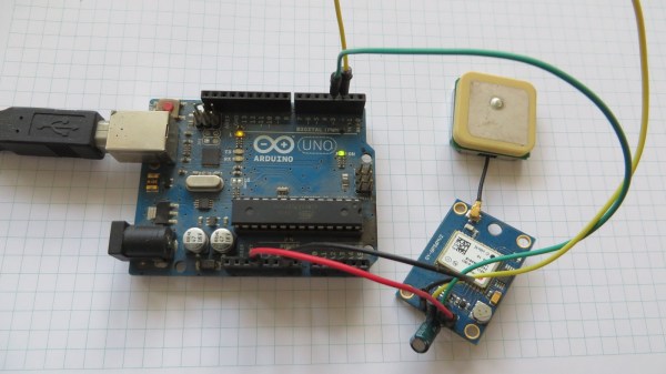
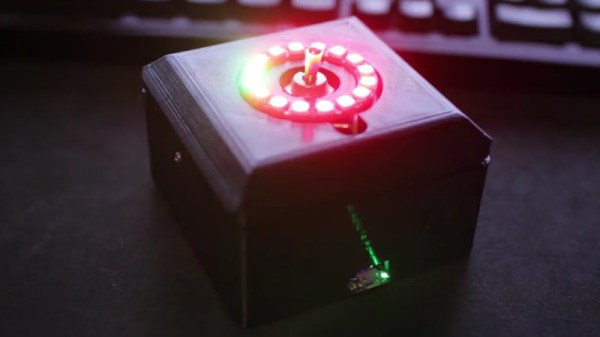
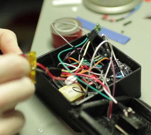
The main components tucked inside of the 3D printed case of the locator are an Adafruit Trinket, a GPS receiver, and a compass module. The Adafruit NeoPixel Ring is of course front and center, serving as the device’s display. To power the device there’s an old battery, a LiPo charger circuit, and a 5V converter.

One of the goals for the project was that it could be constructed out of things [Sean] already had laying around, so some concessions had to be made. The Trinket ended up having too few pins, the compass lacks an accelerometer, and the switches and buttons are a bit clunky for the build. But in the end it comes together well enough to get the job done, and at least he was able to clear some stuff out of his parts bins.

To allow its owner to disassemble and potentially rebuild it into something else later, no soldered joints were used in the construction of the locator. Everything is done with jumper wires, which lead to some interesting problem solving such as using a strip of pin header as a bus bar of sorts. A bit of heat shrink over the bundle holds everything together and prevents shorts.

Location-aware gadgets happen to be an extremely popular gift choice among the hacker crowd. We’ve covered everything from devices cobbled together from trash to hardware which could pass for a commercial product.

Continue reading “Geocache Locator Is The Gift That Keeps On Giving”

Snail Is Actually Cleverly Strange Geocaching Waypoint

Basic geocaching consists of following GPS coordinates to a location, then finding a container which is concealed somewhere nearby. Like any activity, people tend to add their own twists to keep things interesting. [Jangeox] recently posted a video of the OLED Snail 2.0 to show off his most recent work. (This is a refinement of an earlier version, which he describes in a blog post.)

Another of [Jangeox]’s Electronic Waypoints
[Jangeox] spices up geocaching by creating electronic waypoints, and the OLED Snail is one of these. Instead of GPS coordinates sending someone directly to a goal, a person instead finds a waypoint that reveals another set of coordinates and these waypoints are followed like a trail of breadcrumbs.

A typical waypoint is an ATTINY85 microcontroller programmed to display an animated message on the OLED, and the message reveals the coordinates to the next waypoint. The waypoint is always cleverly hidden, and in the case of the OLED Snail 2.0 the enclosure is the shell of a large snail containing the electronics encased in resin. This means that the devices have a finite lifespan — the battery sealed inside is all the power the device gets. Fortunately, with the help of a tilt switch the electronics can remain dormant until someone picks it up to start the show. Other waypoints have included a fake plant, and the fake bolt shown here. Video of the OLED Snail 2.0 is embedded below.

Continue reading “Snail Is Actually Cleverly Strange Geocaching Waypoint”

Don’t Miss Watching This Solar Eclipse High Altitude Balloon Online

[Dan Julio] let us know about an exciting project that he and his team are working on at the Solid State Depot Makerspace in Boulder: the Solar Eclipse High Altitude Balloon. Weighing in at 1 kg and bristling with a variety of cameras, the balloon aims to catch whatever images are able to be had during the solar eclipse. The balloon’s position should be trackable on the web during its flight, and some downloaded images should be available as well. Links for all of that are available from the project’s page.

High altitude balloons are getting more common as a platform for gathering data and doing experiments; an embedded data recorder for balloons was even an entry for the 2016 Hackaday Prize.

If all goes well and the balloon is able to be recovered, better images and video will follow. If not, then at least a post-mortem of what the team thinks went wrong will be posted. Launch time in Wyoming is approximately 10:40 am Mountain Time (UTC -07:00) Mountain Daylight Time (UTC -06:00) on Aug 21 2017, so set your alarm!

The Perfect Tourist Techno-Cap

How many times are you out on vacation and neglect to take pictures to document it all for the folks back at home? Or maybe you forgot just exactly where that awesome waterfall was. [Mark Williams] has made a Raspberry Pi Zero enabled cap that can take photos and geotag them with the location as well as the attitude of the camera.

The idea is to enable the reconstruction of a trip photographically. The hardware consists of a Raspberry Pi Zero W coupled with a Raspberry Camera V2 and a BerryGPS-IMU. Once activated, the system starts taking photos every two minutes. Within each photograph, the location of the photographer is recorded like most GPS enabled camera.

An additional set of data including yaw, pitch, and roll along with direction is also captured to understand where the camera is pointing when the image was taken. Even if he’s tilting his head at the time the photo was taken, the metadata allows it to be straightened out in software later.

This information is decoded using GeoSetter which puts the images on a map along with the field of view. Take a peek at the video below for the result of a trip around Sydney Harbour and the system in action. The Raspberry Pi Zero and camera combo are useful for a lot of things including this soldering microscope. Hopefully, we will be seeing some DIY VR gear with stereo cameras in the near future. Continue reading “The Perfect Tourist Techno-Cap”

GPS Tracker Gets SMS Upgrade

In May of 2000, then-President Bill Clinton signed a directive that would improve the accuracy of GPS for anyone. Before this switch was flipped, this ability was only available to the military. What followed was an onslaught of GPS devices most noticeable in everyday navigation systems. The large amount of new devices on the market also drove the price down to the point where almost anyone can build their own GPS tracking device from scratch.

The GPS tracker that [Vadim] created makes use not just of GPS, but of the GSM network as well. He uses a Neoway M590 GSM module for access to the cellular network and a NEO-6 GPS module. The cell network is used to send SMS messages that detail the location of the unit itself. Everything is controlled with an ATmega328P, and a lithium-ion battery and some capacitors round out the fully integrated build.

[Vadim] goes into great detail about how all of the modules operate, and has step-by-step instructions on their use that go beyond what one would typically find in a mundane datasheet. The pairing of the GSM and GPS modules seems to go match up well together, much like we have seen GPS and APRS pair for a similar purpose: tracking weather balloons.

A Beverage Cooler That Comes To You!

Feel like taking a long walk, but can’t be bothered with carrying your drinks? Have no fear, this  “Follow Me” Cooler Bot is here!

Really just a mobile platform with a cooler on top, the robot connects to smartphone via Bluetooth, following it using GPS. Making the platform involves a little woodworking skill, and an aluminium hub with a 3D-printed hub adapter connects the motors to a pair 6″ rubber wheels with a swivel caster mounted at the rear. A pocket in the platform’s base houses the electronics.

The Arduino Uno — via an L298n motor driver — controls two 12V DC, brushed and geared motors mounted with 3D printed brackets, while a Parallax PAM-7Q GPS Module in conjunction with an HMC 5883L compass help the robot keep its bearing. A duo of batteries power the motors and the electronics separately to prevent  any malfunctions.

Continue reading “A Beverage Cooler That Comes To You!”

Manhattan Marauder’s Map

If you solemnly swear that you are up to no good, and you happen to spend most of your time in Manhattan below the mid-90s, then you will appreciate this Raspberry Pi-based Manhattan Marauder’s Map.

Not that a Harry Potter-themed map was necessarily [GawkyFuse]’s intention when creating this interesting build; it’s just that the old-time print of Manhattan — it shows Welfare Island in the East River, which was renamed Roosevelt Island in 1971 — lends a nice vintage feel to the build. Printed on plain paper, the map overlays a 64×32-LED matrix, which is driven by a matrix HAT riding atop the Pi 3.

[GawkyFuse] uses the OwnTracks app on his and his wife’s iPhone to report their locations back to CloudMQTT. The Pi subscribes to the broker and updates his location in red and her location in blue as they move about the city; a romantic touch is showing a single purple dot when they’re together. There’s no word on what’s displayed when either leaves the map area, but the 2048-pixel display offers a lot of possibilities.

We’ve seen a Weasley clock or two around these parts before, but strangely no Marauder’s Maps like this one. Although this Austrian tram-tracking map comes pretty close to [GawkyFuse]’s nice design.

[via r/raspberry_pi]