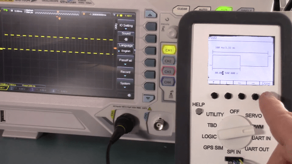
Drone Buoy Drifts Along The Gulf Stream For Citizen Science

It may be named after the most famous volleyball in history, but “Wilson” isn’t just a great conversationalist. [Hayden Brophy] built the free-drifting satellite buoy to see if useful science can be done with off-the-shelf hardware and on a shoestring budget. And from the look of the data so far, Wilson is doing pretty well.

Wilson belongs to a class of autonomous vessels known as drifters, designed to float along passively in the currents of the world’s ocean. The hull of [Hayden]’s drifter is a small Pelican watertight case, which contains all the electronics: Arduino Pro Trinket, GPS receiver, a satellite modem, and a charger for the LiPo battery. The lid of the case is dominated by a 9 W solar panel, plus the needed antennas for GPS and the Iridium uplink and a couple of sensors, like a hygrometer and a thermometer. To keep Wilson bobbing along with his solar panel up, there’s a keel mounted to the bottom of the case, weighted with chains and rocks, and containing a temperature sensor for the water.

Wilson is programmed to wake up every 12 hours and uplink position and environmental data as he drifts along. The drifter was launched into the heart of the Gulf Stream on August 8, about 15 nautical miles off Marathon Key in Florida, by [Captain Jim] and the very happy crew of the “Raw Deal”. As of this writing, the tracking data shows that Wilson is just off the coast of Miami, 113 nautical miles from launch, and drifting along at a stately pace of 2.5 knots. Where the buoy ends up is anyone’s guess, but we’ve seen similar buoys make it all the way across the Atlantic, so here’s hoping that hurricane season is kind to Wilson.

We think this is great, and congratulations to [Hayden] for organizing a useful and interesting project.

Continue reading “Drone Buoy Drifts Along The Gulf Stream For Citizen Science”

Do You Know Where Your Children Are? Check The Weasley Clock

What’s the coolest thing you could build for a Harry Potter fan, aside from a working magic wand or Quidditch broomstick? We would have to say a Weasley clock that shows the whereabouts of everyone in the family is pretty high on the list, especially if that fan is a wife and mother.

Here’s how it works: they’ve set up geofences to define the boundaries of home, each person’s school or workplace, and so on. The family’s locations are tracked through their phones’ GPS using Home Assistant, which is hosted on a Raspberry Pi. Whenever someone’s location changes, the Pi alerts the clock over MQTT, and it moves the 3D-printed hands with servos.

The clock has some interesting granularity to it as well. As someone gets closer to home, their pointer’s distance reflects that in its proximity to the Home slice. And Home itself is divided into the main house and the shop and reflected by the pointer’s position.

We particularly like the attention to detail here, like the art poster used for the clock’s face that includes all the Weasley’s whereabouts in the background. It’s built into a thrift store grandmother clock, which is smaller than a grandfather clock but no less majestic. In the future there are plans to implement the clock’s chimes to announce that someone is back home.

No matter what you’re into, the whereabouts clock idea can probably fit that universe. For instance, here’s one that uses LEGO mini-fig heads to locate roommates.

Not Just GPS: New Options For Global Positioning

A few weeks ago, China launched the final satellite in its BeiDou-3 satellite positioning system. Didn’t know that China had its own GPS? How about Europe’s Galileo, Russia’s GLONASS, or Japan’s QZSS? There’s a whole world of GPS-alikes out there. Let’s take a look.

Continue reading “Not Just GPS: New Options For Global Positioning”

Number Crunching GPS For The DIYer

Many of us have had cause to add GPS to a project, whether it’s because we need an accurate timebase or just want to know where the bloody thing is. Normally, this consists of plugging in a cheap module and making sure the antenna has a good view of the sky. [Mike] wanted to dig deeper, however, and figure out just what goes into decoding a GPS signal and calculating a location fix.

[Mike]’s investigation combined several avenues of investigation. In terms of decoding live radio signals, he selected a KiwiSDR software defined radio. Combined with a Digilent Nexys 2 FPGA, it was now possible to get live data off the air and into the PC quickly for decoding. In concert with this, [Mike] used a sample of raw GPS data captured in Nottingham, UK in order to test his code. After much experimentation, [Mike] was able to get the data decoded with 700 lines of C code. Decoding three minutes worth of data took all night, but further development allowed things to be sped up over 200 times. For the curious, the code is up on Github to convert raw ADC samples into actual location fixes.

Armed with the wealth of resources online and the right hardware, [Mike] was sucessfully able to achieve his goal, and figure out just precisely where his house is, to boot. As a bonus, the whole project was inspired by a similar project posted in these very pages back in 2013! If you’re working on your own satellite-based projects, be sure to drop us a line.

Capture The Flag, Along With The Game Data

With events of all sizes on hold and live sports mostly up in the air, it’s a great time to think of new ways to entertain ourselves within our local circles. Bonus points if the activity involves running around outside, and/or secretly doubles as a team-building exercise, like [KarelBousson]’s modernized version of Capture the Flag.

Much like the original, the point of this game is to capture the case and keep it for as long as possible before the other team steals it away. Here, the approach is much more scientific: the box knows exactly who has it and for how long, and the teams get points based on the time the case spends in any player’s possession.

Each player carries an RFID tag to distinguish them from each other. Inside the case is an Arduino Mega with a LoRa shield and a GPS unit. Whenever the game is afoot, the case communicates its position to an external Raspi running the game server.

If you haven’t met LoRa yet, check out this seven-part introductory tutorial.

Sun-Seeking Sundial Self-Calibrates In No Time

Sundials, one of humanity’s oldest ways of telling time, are typically permanent installations. The very good reason for this is that telling time by the sun with any degree of accuracy requires two-dimensional calibration — once for cardinal direction, and the other for local latitude.

[poblocki1982] is an amateur astronomer and semi-professional sundial enthusiast who took the time to make a self-calibrating equatorial ‘dial that can be used anywhere the sun shines. All this solar beauty needs is a level surface and a few seconds to find its bearings.

Switch it on, set it down, and the sundial spins around on a continuous-rotation servo until the HMC5883L compass module finds the north-south orientation. Then the GPS module determines the latitude, and a 180° servo pans the plate until it finds the ideal position. Everything is controlled with an Arduino Nano and runs on a 9V battery, although we’d love to see it run on solar power someday. Or would that be flying too close to the sun? Check out how fast this thing calibrates itself in the short demo after the break.

Not quite portable enough for you? Here’s a reverse sundial you wear on your wrist.

Custom Firmware Makes A LoRA-Enabled HAB Tracker Watch

High Altitude Balloons (HAB) are a great way to get all kinds of data and shoot great photos and video, but what goes up must come down. Once the equipment has landed, one must track it down. GPS and LoRA, with its long wireless range and ease of use, are invaluable tools in tracking payloads that have returned to Earth. [Dave Akerman] has made handheld receivers to guide him to payloads, but wanted something even smaller; ideally something that could be worn on the wrist.

One day he came across the affordable LilyGo T-Watch which includes GPS and LoRA functionality, and he started getting ideas. The watch has the features, but the stock firmware didn’t measure up. Not to be deterred, [Dave] wrote new firmware to turn the device into a wrist-worn GPS and LoRA chase watch.

Not only is the new firmware functional, but it’s got a wonderful user interface. GitHub repository for the new firmware is here, and you can see the UI in action in the brief video embedded below.

Continue reading “Custom Firmware Makes A LoRA-Enabled HAB Tracker Watch”