Satellite Communications Hack Chat

Join us on Wednesday, June 2 at noon Pacific for the Satellite Comms Hack Chat with Paul Marsh!

All things considered, space isn’t that far away; you could drive the equivalent distance in an hour or two, with time for a couple of stops on the way. Of course, getting to space isn’t as simple as a Sunday drive, and yet despite the expense and trouble, we’ve still managed to fill our little corner of the solar system with an astonishing number of satellites.

Almost every single one of the spacecraft we’ve put in orbit represents a huge capital investment, both in terms of building something that can withstand the extreme environment up there and as far as the expense involved in getting it there. So once it gets there, it needs to start producing results, and for the most part that means sending some kind of messages back down to Earth. And those communications can be tempting indeed to hardware hackers.

Monitoring messages from on high is what the satcom radio hobby is all about. Learning how to do it properly can be tricky, though. What frequencies does one use? What are the modulation schemes? What kind of antennas would someone need? And what about tracking these birds as they whizz overhead?

To answer these questions and more, Paul Marsh from UHF-Satcom will stop by the Hack Chat. Paul has been interested in satellites since the early 1990s and coupled with his background in infosec and pentesting, he has uncovered a lot about the ins and outs of satellite snooping. Stop by the Hack Chat and learn how to sniff in on what’s going on upstairs.

join-hack-chatOur Hack Chats are live community events in the Hackaday.io Hack Chat group messaging. This week we’ll be sitting down on Wednesday, June 2 at 12:00 PM Pacific time. If time zones have you tied up, we have a handy time zone converter.

Click that speech bubble to the right, and you’ll be taken directly to the Hack Chat group on Hackaday.io. You don’t have to wait until Wednesday; join whenever you want and you can see what the community is talking about.

Hackaday Links Column Banner

Hackaday Links: May 2, 2021

Mars is getting to be a busy place, what with helicopters buzzing around and rovers roving all about the place. Now it’s set to get a bit more crowded, with the planned descent of the newly-named Chinese Zhurong rover. Named after the god of fire from ancient Chinese mythology, the rover, which looks a little like Opportunity and Spirit and rides to the surface aboard something looking a little like the Viking lander, will carry a suite of scientific instruments around Utopia Planitia after it lands sometime this month. Details are vague; China usually plays its cards close to the vest, and generally makes announcements only when a mission is a fait accompli. But it appears the lander will leave its parking orbit, which it entered back in February, sometime this month. It’s not an easy ride, and we wish Zhurong well.

Speaking of space, satellites don’t exactly grow on trees — until they do. A few groups, including a collaboration between UPM Plywood and Finnish startup Arctic Astronautics, have announced intentions to launch nanosatellites made primarily of wood. Japanese logging company Sumitomo Forestry and Kyoto University also announced their partnership, formed with the intention to prove that wooden satellites can work. While it doesn’t exactly spring to mind as a space-age material, wood does offer certain advantages, including relative transparency to a wide range of the RF spectrum. This could potentially lead to sleeker satellite designs, since antennae and sensors could be located inside the hull. Wood also poses less of a hazard than a metal spaceframe does when the spacecraft re-enters the atmosphere. But there’s one serious disadvantage that we can see: given the soaring prices for lumber, at least here in the United States, it may soon be cheaper to build satellites out of solid titanium than wood.

If the name Ian Davis doesn’t ring a bell with you, one look at his amazing mechanical prosthetic hand will remind you that we’ve been following his work for a while now. Ian suffered a traumatic amputation of the fingers of his left hand, leaving only his thumb and palm intact, and when his insurance wouldn’t pay for a prosthetic hand, he made his own. Ian has gone through several generations, each of which is completely mechanical and controlled only by wrist movements. The hands are truly works of mechanical genius, and Ian is now sharing what he’s learned to help out fellow hand-builders. Even if you’re not building a hand, the video is well worth watching; the intricacy of the whiffle-tree mechanism used to move the fingers is just a joy to behold, and the complexity of movement that Ian’s hand is capable of is just breathtaking.

If mechanical hands don’t spark your interest, then perhaps the engineering behind top fuel dragsters will get you going. We’ll admit that most motorsports bore us to tears, even with the benefit of in-car cameras. But there’s just something about drag cars that’s so exciting. The linked video is a great dive into the details of the sport, where engines that have to be rebuilt after just a few seconds use, fuel flows are so high that fuel lines the size of a firehouse are used, and the thrust from the engine’s exhaust actually contributes to the car’s speed. There’s plenty of slo-mo footage in the video, including great shots of what happens to the rear tires when the engine revs up. Click through the break for more!

Continue reading “Hackaday Links: May 2, 2021”

Satellite Ground Station Upcycles Trash

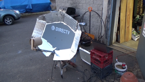
While the term “upcycle” is relatively recent, we feel like [saveitforparts] has been doing it for a long time. He’d previously built gear to pick up low-Earth orbit satellites, but now wants to pick up geosynchronous birds which requires a better antenna. While his setup won’t win a beauty contest, it does seem to work, and saved some trash from a landfill, too. (Video, embedded below.)

Small dishes are cheap on the surplus market. A can makes a nice feedhorn using a classic cantenna design, although that required aluminum tape since the only can in the trash was a cardboard oatmeal carton. The tape came in handy when the dish turned out to be about 25% too small, as well.

Continue reading “Satellite Ground Station Upcycles Trash”

Putting Perseverance Rover’s View Into Satellite View Context

It’s always fun to look over aerial and satellite maps of places we know, seeing a perspective different from our usual ground level view. We lose that context when it’s a place we don’t know by heart. Such as, say, Mars. So [Matthew Earl] sought to give Perseverance rover’s landing video some context by projecting onto orbital imagery from ESA’s Mars Express. The resulting video (embedded below the break) is a fun watch alongside the technical writeup Reprojecting the Perseverance landing footage onto satellite imagery.

Some telemetry of rover position and orientation were transmitted live during the landing process, with the rest recorded and downloaded later. Surprisingly, none of that information was used for this project, which was based entirely on video pixels. This makes the results even more impressive and the techniques more widely applicable to other projects. The foundational piece is SIFT (Scale Invariant Feature Transform), which is one of many tools in the OpenCV toolbox. SIFT found correlations between Perseverance’s video frames and Mars Express orbital image, feeding into a processing pipeline written in Python for results rendered in Blender.

While many elements of this project sound enticing for applications in robot vision, there are a few challenges touched upon in the “Final Touches” section of the writeup. The falling heatshield interfered with automated tracking, implying this process will need help to properly understand dynamically changing environments. Furthermore, it does not seem to run fast enough for a robot’s real-time needs. But at first glance, these problems are not fundamental. They merely await some motivated people to tackle in the future.

This process bears some superficial similarities to projection mapping, which is a category of projects we’ve featured on these pages. Except everything is reversed (camera instead of video projector, etc.) making the math an entirely different can of worms. But if projection mapping sounds more to your interest, here is a starting point.

[via Dr. Tanya Harrison @TanyaOfMars]

Continue reading “Putting Perseverance Rover’s View Into Satellite View Context”

Sirius XM Satellite Failure A Reminder That Space Is Risky (And That Satellite Insurance Is A Thing)

It’s easy to imagine that once a spacecraft leaves Earth’s atmosphere and is in a stable orbit, the most dangerous phase of the mission is over. After all, that’s when we collectively close the live stream and turn our attentions back to terrestrial matters. Once the fire and fury of the launch is over with, all the excitement is done. From that point on, it’s just years of silently sailing through the vacuum of space. What’s the worst that could happen?

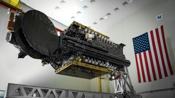
Unfortunately, satellite radio provider Sirius XM just received a harsh reminder that there’s still plenty that can go wrong after you’ve slipped Earth’s surly bonds. Despite a flawless launch in early December 2020 on a SpaceX Falcon 9 and a reportedly uneventful trip to its designated position in geostationary orbit approximately 35,786 km (22,236 mi) above the planet, their brand new SXM-7 broadcasting satellite appears to be in serious trouble.

Maxar Technologies, prime contractor for the SXM-7, says they’re currently trying to determine what’s gone wrong with the 7,000 kilogram satellite. In a statement, the Colorado-based aerospace company claimed they were focused on “safely completing the commissioning of the satellite and optimizing its performance.” But the language used by Sirius XM in their January 27th filing with the U.S. Securities and Exchange Commission was notably more pessimistic. No mention is made of bringing SXM-7 online, and instead, the company makes it clear that their existing fleet of satellites will be able to maintain service to their customers until a replacement can be launched.

So what happened, and more importantly, is there any hope for SXM-7? Neither company has released any concrete details, and given the amount of money on the line, there’s a good chance the public won’t get the full story for some time. But we can theorize a bit based on what we do know, and make some predictions about where things go from here.

Continue reading “Sirius XM Satellite Failure A Reminder That Space Is Risky (And That Satellite Insurance Is A Thing)”

Japan To Launch Wooden Satellites

We may have wooden satellites in just a few years, according to an announcement this month by Kyoto University and Sumitomo Forestry, organizations whose combined roots go back 550 years.

Wood’s place in high-technology has a long track record. During World War 2, wooden boats were used for minesweepers, the Spruce Goose was designed to circumvent wartime material restrictions, and Britain’s plywood-built De Havilland Mosquito had a very low radar cross section. In this century, a man in Bosnia has even built a Volkswagen Beetle out of oak.

The newly-announced aerospace project, led by retired astronaut and engineer Prof Takao Doi, plans to launch satellites built from wood in order to reduce space debris and hazardous substances resulting from re-entry. We’re somewhat skeptical on the hazardous substances angle (and we’re not alone in this), but certainly as a way to help ensure complete burn up upon re-entry, wood is an interesting material. It also achieves a great strength to weight ratio and as a renewable resource it’s easy to source.

Prof Doi has been studying the use of wood in space for several years now. Back in 2017 he began basic research on the usability of timbers in space (pg 16), where his team experimented with coniferous (cedar and cypress) and hardwood (satinwood, magnolia, and zelkova) trees in vacuum environments. Based on successes, they predicted wooden satellite launches in the mid 2020s (their announcement this month said 2023). Sumitomo engineers have not released what kind of wood(s) will finally be used on the satellite.

You might remember Astronaut Doi from an experiment aboard the ISS where he successfully demonstrated flying a boomerang in space (video below), and he’s also discovered two supernovae in his spare time. We wish him good luck.

Continue reading “Japan To Launch Wooden Satellites”

Hackaday Links Column Banner

Hackaday Links: November 15, 2020

Now that we drive around cars that are more like mobile data centers than simple transportation, there’s a wealth of data to be harvested when the inevitable crashes occur. After a recent Tesla crash on a California highway, a security researcher got a hold of the car’s “black box” and extracted some terrifying insights into just how bad a car crash can be. The interesting bit is the view of the crash from the Tesla’s forward-facing cameras with object detection overlays. Putting aside the fact that the driver of this car was accelerating up to the moment it rear-ended the hapless Honda with a closing speed of 63 MPH (101 km/h), the update speeds on the bounding boxes and lane sensing are incredible. The author of the article uses this as an object lesson in why Level 2 self-driving is a bad idea, and while I agree with that premise, the fact that self-driving had been disabled 40 seconds before the driver plowed into the Honda seems to make that argument moot. Tech or not, someone this unskilled or impaired was going to have an accident eventually, and it was just bad luck for the other driver.

Last week I shared a link to Scan the World, an effort to 3D-scan and preserve culturally significant artifacts and create a virtual museum. Shortly after the article ran we got an email from Elisa at Scan the World announcing their “Unlocking Lockdown” competition, which encourages people to scan cultural artifacts and treasures directly from their home. You may not have a Ming Dynasty vase or a Grecian urn on display in your parlor, but you’ve probably got family heirlooms, knick-knacks, and other tchotchkes that should be preserved. Take a look around and scan something for posterity. And I want to thank Elisa for the link to the Pompeiian bread that I mentioned.

The Defense Advanced Research Projects Agency (DARPA)has been running an interesting challenge for the last couple of years: The Subterranean (SubT) Challenge. The goal is to discover new ways to operate autonomously below the surface of the Earth, whether for mining, search and rescue, or warfare applications. They’ve been running different circuits to simulate various underground environments, with the most recent circuit being a cave course back in October. On Tuesday November 17, DARPA will webcast the competition, which features 16 teams and their autonomous search for artifacts in a virtual cave. It could make for interesting viewing.

If underground adventures don’t do it for you, how about going upstairs? LeoLabs, a California-based company that specializes in providing information about satellites, has a fascinating visualization of the planet’s satellite constellation. It’s sort of Google Earth but with the details focused on low-earth orbit. You can fly around the planet and watch the satellites whiz by or even pick out the hundreds of spent upper-stage rockets still up there. You can lock onto a specific satellite, watch for near-misses, or even turn on a layer for space debris, which honestly just turns the display into a purple miasma of orbiting junk. The best bit, though, is the easily discerned samba-lines of newly launched Starlink satellites.

A doorbell used to be a pretty simple device, but like many things, they’ve taken on added complexity. And danger, it appears, as Amazon Ring doorbell users are reporting their new gadgets going up in flame upon installation. The problem stems from installers confusing the screws supplied with the unit. The longer wood screws are intended to mount the device to the wall, while a shorter security screw secures the battery cover. Mix the two up for whatever reason, and the sharp point of the mounting screw can find the LiPo battery within, with predictable results.

And finally, it may be the shittiest of shitty robots: a monstrous robotic wolf intended to scare away wild bears. It seems the Japanese town of Takikawa has been having a problem with bears lately, so they deployed a pair of these improbable looking creatures to protect themselves. It’s hard to say what’s the best feature: the flashing LED eyes, the strobe light tail, the fact that the whole thing floats in the air atop a pole. Whatever it is, it seems to work on bears, which is probably good enough. Take a look in the video below the break.

Continue reading “Hackaday Links: November 15, 2020”