Keep Tabs On Asteroids With Asteroid Atlas

Keeping tabs on the night sky is an enjoyable way to stay connected to the stars, and astronomy can be accessible to most people with a low entry point for DIY telescopes. For those who live in areas with too much light pollution, though, cost is not the only issue facing amateur astronomers. Luckily there are more ways to observe the night sky, like with this open source software package from [elanorlutz] which keeps tabs on all known asteroids.

The software is largely based on Python and uses a number of databases from NASA to allow anyone with a computer to explore various maps of the solar system and the planetary and non-planetary bodies within it. Various trajectories can be calculated, and paths of other solar system bodies can be shown with respect to an observer in various locations. Once the calculations are made in Python it is able to export the images for use in whichever image manipulation software you prefer.

The code that [elanorlutz] has created is quite extensive and ready to use for anyone interested in tracking comets, trans-Neptunian objects, or even planets and moons from their own computer. We would imagine a tool like this would be handy for anyone with a telescope as well as it could predict locations of objects in the night sky with accuracy and then track them with the right hardware.

Antique Map Of Paris With Modern Tech

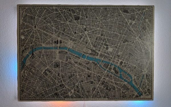
There’s plenty to love about antiques, from cars, furniture, to art. While it might be a little bit of survivorship bias, it’s easy to appreciate these older things for superior quality materials, craftsmanship, or even simplicity. They are missing out on all of our modern technology, though, so performing “restomods” on classics is a popular activity nowadays. This antique map of Paris, for example, is made of a beautiful hardwood but has been enhanced by some modern amenities as well.

At first the creator of this project, [Marc], just wanted to give it some ambient lighting, but it eventually progressed over the course of two years to have a series of Neopixels hidden behind it that illuminate according to the current sun and moon positions. The Neopixels get their instructions from an ESP8266 which calculates these positions using code [Marc] wrote himself based on the current date. Due to the limitations of the ESP8266 it’s not particularly precise, but it gets the job done to great effect.

To improve on the accuracy, [Marc] notes that an ESP32 could be used instead, but we can give the ESP8266 a pass for now since the whole project is an excellent art installation even if it is slightly off on its calculations. If you need higher accuracy for tracking celestial objects, you can always grab a Raspberry Pi too.

Lost A Lightweight Quadcopter? Here Are The Best Ways To Find It

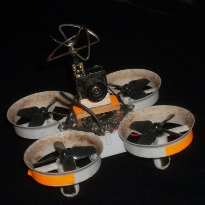
Lost aircraft are harder to find when they are physically small to begin with. Not only are they harder to see, but the smaller units lack features like GPS tracking; it’s not normally possible to add it to a tiny aircraft that can’t handle much more than its own weight in the first place. As a result, little lost quads tend to be trickier to recover in general.

Fluorescent tape adds negligible weight, and will glow brightly at night under a UV light.

The good news is that [Eric Brasseur] has shared some concise tips on how to more easily locate and recover lost aircraft, especially lightweight ones. Recovering aircraft is something every aircraft hobbyist has had to deal with in one way or another, but [Eric] really has gathered an impressive list of tricks and techniques, and some of them go into some really useful additional detail. It occurs to us that a lot of these tips could apply equally well to outdoor robots, or rovers.

Even simple techniques can be refined. For example, using bright colors on an aircraft is an obvious way to increase visibility, but some colors are better choices than others. Bright orange, white, and red are good choices because they are easily detected by the human eye while still being uncommon in nature. Violet, blue, and even cyan on the other hand may seem to be good choices when viewed indoors on a workbench, but if the quad is stuck in dark bushes, those colors will no longer stand out. Another good tip is to consider also adding a few patches of fluorescent tape to the aircraft. If all else fails, return at night with a UV lamp; those patches will glow brightly, and be easily seen from tens of meters.

Some of the tips are used while the device still has power, while others don’t depend on batteries holding out. [Eric] does a great job of summing up those and many more, so take a look. They might come in handy when test flying quadcopters that are little more than an 18650 cell, motors, and a 3D-printable frame.

Tracking Satellites: The Nitty Gritty Details

If you want to listen to satellites, you have to be able to track them as they pass over the sky. When I first started tracking amateur satellites, computing the satellite’s location in the sky was a part of the challenge. Nowadays, that’s trivial. What’s left over are all the extremely important real-world details.  Let’s take a look at a typical ham satellite tracking setup and see how it all ties together.

Rotators for Steering

The popularity of robotics, 3D printing, and CNC machines has resulted in a deluge of affordable electric motors and drivers. It’s hard to imagine that an electric motor for rotating an antenna would be anything special, but in fact, antenna rotators are non-trivial engineering designs. Most of the challenges are mechanical, not electrical — the antennas that they drive can be huge, have significant wind loading and rotational inertial, and just downright weigh a lot. A rotator design has to consider bearings, weather exposure, all kinds of loads, not just rotational. And usually a brake is required to keep the antenna pointed in windy conditions.

There’s been a 70-some year history of these mechanisms from back in the 1950s when Cornell Dubilier Electronics, the company you know as a capcacitor manufacturer, began making these rotators for television antennas in the 1950s. I was a little surprised to see that the rotator systems you can buy today are not very different from the ones we used in the 1980s, other than improved electronic controls. Continue reading “Tracking Satellites: The Nitty Gritty Details”

Roll Your Own Tracking

The smartphone is perhaps the signature device of our modern lives. For most of the population it is never more than an arm’s length away, it’s on your person more than any other device in your life. Smartphones are packed with all sorts of radios and ways to communicate wireless. [Amine Mansouri] built an ESP8266 based tracking device that takes advantage of this.

Most WiFi-enabled devices will send out “probe requests” frames trying to search for the SSIDs they were connected to. These packets contain the device MAC address as well as the SSIDs you’ve connected to. Using about 12 components, [Amine] laid out a small board in Eagle. By putting the ESP8266 in monitor mode, the probe frames can be logged and uploaded. The code can be updated OTA making it easy to service while in the field.

With permission from his local library, eight repeater boards were scattered throughout the building to forward the probe packets to where the tracker could pick them up. A simple web interface was built that allows the library to figure out how many people are in the library and how often they frequent the premises.

While an awesome project with open-source code on Github, it is important to stress how important is it to get permission to do this kind of tracking. While some phones implement MAC randomization, there are still many out in the wild that don’t. While this is similar to another project that listens to radio signals to determine the coming and going of ships and planes, tracking people with this sort of granularity is in a different category altogether.

Thanks [Amine] for sending this one in!

Untethered: Fishing Without Lines

There’s a laundry list of ways that humans are polluting the earth, and even though it might not look like it from the surface, the oceans seem to bear the brunt of our waste. Some research suggests that plastic doesn’t fully degrade as it ages, but instead breaks down into smaller and smaller bits that will be somewhere the in environment for such a long time it could be characterized in layman’s terms as forever.

Not only does waste of all kinds make its way to the oceans by rivers or simply by outright dumping, but commercial fishing gear is estimated to comprise around 10% of the waste in the great blue seas, and one of the four nonprofits help guide this year’s Hackaday Prize is looking to eliminate some of that waste and ensure it doesn’t cause other problems for marine life. This was the challenge for the Conservation X Labs dream team, three people who were each awarded a $6,000 micro-grant to work full time for two months on the problem.

It isn’t about simply collecting waste in the ocean, but rather about limiting the time that potentially harmful but necessary fishing equipment is in the water in the first place. For this two-month challenge, this team focused on long lines used by professional fishing operations to attach buoys to gear like lobster pots or crab traps. These ropes are a danger to large ocean animals such as whales when they get tangled in them and, if the lines detach from the traps, the traps themselves continue to trap and kill marine life for as long as they are lost underwater. This “ghost gear” is harmful in many different ways, and reducing its time in the water or “soak time” was the goal for the project.

Let’s take a closer look at their work after the break, and we can also see the video report they filed as the project wrapped up.

Continue reading “Untethered: Fishing Without Lines”

Quality Control, Done Anywhere

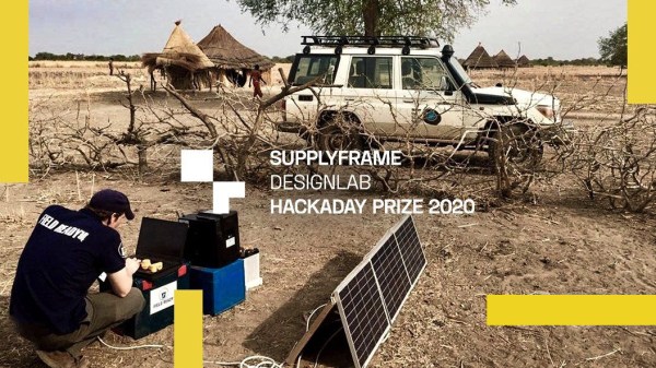
Modern society has brought us all kinds of wonders, including rapid intercontinental travel, easy information access, and decreased costs for most consumer goods thanks to numerous supply chains. When those supply chains break down as a result of a natural disaster or other emergency, however, the disaster’s effects can be compounded without access to necessary supplies. That’s the focus of Field Ready, a nonprofit that sets up small-scale manufacturing in places without access to supply chains, or whose access has been recently disrupted.

As part of this year’s Hackaday Prize, a each of our four nonprofit partners outline specific needs that became the targets of a design and build challenge. Field Ready was one of those nonprofits, and for the challenge they focused on quality control for their distributed manufacturing system. We took a look at Field Ready back in June to explore some of the unique challenges associated with their work, which included customers potentially not knowing that a product they procured came from Field Ready in the first place, leading to very little feedback on the performance of the products and nowhere to turn when replacements are needed.

The challenge was met by a dream team whose members each received a $6,000 microgrant to work full time on the project. The’ve just made their report on an easier way of tracking all of the products produced, and identifying them even for those not in the organization. As a result, Field Ready has a much improved manufacturing and supply process which allows them to gather more data and get better feedback from users of their equipment. Join us after the break for a closer look at the system and to watch the team’s presentation video.

Continue reading “Quality Control, Done Anywhere”