Satellite Provides Detailed Data On Antarctic Ice

Ever since the first satellites started imaging the Earth, scientists have been using the data gathered to learn more about our planet and improve the lives of its inhabitants. From weather forecasting to improving crop yields, satellites have been put to work in a wide array of tasks. The data they gather can go beyond imaging as well. A new Chinese satellite known as Fengyun-3E is using some novel approaches to monitor Antarctic sea ice in order to help scientists better understand the changing climate at the poles.

While it is equipped with a number of other sensors, one of the more intriguing is a piece of equipment called WindRad which uses radar to measure wind at various locations and altitudes based on how the radar waves bounce off of the atmosphere at various places.  Scientists have also been able to use this sensor to monitor sea ice, and can use the data gathered to distinguish new sea ice from ice which is many years old, allowing them to better understand ice formation and loss at the poles. It’s also the first weather satellite to be placed in an early morning orbit, allowing it to use the long shadows cast by the sun on objects on Earth’s surface to gather more information than a satellite in other orbits might be able to.

With plenty of other imaging sensors on board and a polar orbit, it has other missions beyond monitoring sea ice. But the data that it gathers around Antarctica should give scientists more information to improve climate models and understand the behavior of sea ice at a deeper level. Weather data from satellites like these isn’t always confined to academia, though. Plenty of weather satellites broadcast their maps and data unencrypted on radio bands that anyone can access.

A Brief History Of Weather Control

It used to be a common expression to say that something would happen when “people walked on the moon.” That is, something that was never going to happen. Of course, by 1960, it was clear that someone was going to walk on the moon eventually. There were many other things everyone “knew” would happen in the future. Some of them came true, but many of them didn’t. Some, like video phones and robot factory workers, came true in a way, but not as people imagined. For example, people were confident that computers would easily translate between human languages, something we still have trouble doing entirely reliably. Another standard prediction is that people would control the weather.

Controlling the weather, in some ways, seems even less likely than walking on the moon. After all, we know where the moon is and where it will be. We still don’t understand precisely what causes the weather to behave the way it does. We have models and plenty of scientific theories. But you still can’t know exactly what’s going to happen, where, or when.

History

If you farm or live in a hut, weather is especially important. You want rain but not too much rain. Without scientific knowledge, many cultures had rain-making superstitions like a rain dance or other rituals meant to encourage rain. Some think that loud noises like cannon fire prevent hail.  Charlatans would promise rain in exchange for donations.

However, science would eventually surface, and in the 1800’s James Espy — the first U.S. meteorologist — theorized that convection was what really caused rain. He had bold plans to set massive fires to encourage rain but could not convince Congress to go along.

Half a century later, Robert St. George Dyrenforth tested the effect of explosions on rainfall. There is no evidence that his cannon and fireworks did anything. He did, however, claim credit for any rain that happened to occur nearby. There have been many reports that explosions cause rain — rain often falls after a heated battle, apparently.  The government in Thailand tried to induce rain using dry ice flakes dropped into clouds with, reportedly, some success. Abu Dhabi, Russia, and China’s governments claim to have working weather control today.

Continue reading “A Brief History Of Weather Control”

Building A Weather Display In Rust

We’ve seen a lot of weather displays over the years, and plenty of the more modern ones have been using some form of electronic paper. So what makes this particular build from [Harry Stern] different? The fact that the firmware running on the ESP32 microcontroller at its heart was developed in Rust.

The weather station itself is capable of operating for several months on its rechargeable NiMH battery bank. The Rust section of the project is in two parts, the first of which runs on a server which downloads the weather data and aggregates it into an image. The second part runs on the ESP32 using esp-idf which configures peripherals, turns on and connects to Wi-Fi, retrieves the image from the server, displays the image and then puts the display to sleep. By doing the heavy lifting on the server, the display should be able to run for longer than it would if everything was happening on the ESP32.

The project code is available from this GitHub page which should allow even Rust beginners to follow along, and the case file is also available for those with a 3D printer. [Harry] has a few upgrades planned for future releases as well, including a snap-fit case, a custom PCB, and improved voltage regulator for better battery life, and enhanced error handling for the weather API. And Rust isn’t the only interesting part of this project, either. As prices for e-paper displays continue to fall, more and more of them are found in projects like weather stations and even complete laptops which use these displays exclusively.

Weather In Wartime: The Importance Of British Meteorology In WWII

Weather can have a significant impact on transport and operations of all kinds, especially those at sea or in the air. This makes it a deeply important field of study, particularly in wartime. If you’re at all curious about how this kind of information was gathered and handled in the days before satellites and computer models, this write-up on WWII meteorology is sure to pique your interest.

Weather conditions were valuable data, and weather forecasts even more so. Both required data, which relied on human operators for instruments to be read and their readings transmitted.

The main method of learning weather conditions over the oceans is to persuade merchant ships to report their observations regularly. This is true even today, but these days we also have the benefit of things like satellite technology. Back in the mid-1900s there was no such thing, and the outbreak of WWII (including the classification of weather data as secret information due to its value) meant that new solutions were needed.

The aircraft of the Royal Air Force (RAF) were particularly in need of accurate data, and there was little to no understanding of the upper atmosphere at the time. Eventually, aircraft flew regular 10-hour sorties, logging detailed readings that served to provide data about weather conditions across the Atlantic. Readings were logged, encoded with one-time pad (OTP) encryption, then radioed back to base where charts would be created and updated every few hours.

The value of accurate data and precise understanding of conditions and how they could change was grimly illustrated in a disaster called the Night of the Big Wind (March 24-25, 1944). Forecasts predicted winds no stronger than 45 mph, but Allied bombers sent to Berlin were torn apart when they encountered winds in excess of 120 mph, leading to the loss of 72 aircraft.

The types of data recorded to monitor and model weather are nearly identical to those in modern weather stations. The main difference is that instruments used to be read and monitored by human beings, whereas today we can rely more on electronic readings and transmission that need no human intervention.

Know Snow: Monitoring Snowpack With The SNOTEL Network

With summer just underway here in North America, it may seem like a strange time to talk about snow. But when you live in North Idaho, winter is never very far away and is always very much on everyone’s mind. Our summers are fierce but all too brief, so starting around September, most of us begin to cast a wary eye at the peaks of the Bitterroot range in the mornings, looking for the first signs of snow. And in the late spring, we do much the same, except longingly looking for the first signs that the snowpack is finally breaking up.

We all know how important snow is, of course. Snow is our lifeline, nearly the only source of drinking water we have here, as well as the foundation of our outdoor recreation industries. We also know that the snowpack determines our risk for wildfires, so while the long, dark winters may take a psychological toll, the longer the snow stays on the mountains, the less chance we have of burning come summer.

These are all very subjective measures, though, and there’s way too much riding on the snowpack to leave it up to casual observation. To make things more quantitative, the US Department of Agriculture’s Natural Resources Conservation Service (NRCS) has built a system across the western US that measures the snowpack in real-time, and provides invaluable data to climatologists, fish and game managers, farmers, and even the recreation industry, all of whom have a vested interest in the water held within. The network is called SNOTEL, and I recently got a chance to take a field trip with a hydrologist and get an up-close look at how it works.

Continue reading “Know Snow: Monitoring Snowpack With The SNOTEL Network”

Raspberry Pi Weather Station Features Wireless Sensor Nodes

Online weather services are great for providing generic area forecasts, but they don’t provide hyperlocal data specific to your location. [Harald Kreuzer] needed both and built a Raspberry Pi Weather Station that provides weather forecasts for the next 7 days as well as readings from local sensors. The project is completely open source and based on a Raspberry Pi base station which connects to ESP32 based sensor nodes and online services to nicely present the data on a 7″ touch screen display.

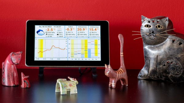
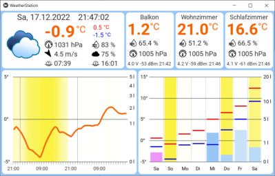
The architecture is quite straightforward. The ESP32 based sensor nodes publish their readings to an MQTT broker running on the Raspberry Pi. The Pi subscribes to these sensor node topics to pick up the relevant sensor data. This makes it easy to add additional sensor nodes in future. Weather forecast data is collected by connecting to the OpenWeatherMap API. All of the collected information is then displayed through an app built using the Kivy: open source Python app development framework. Continue reading “Raspberry Pi Weather Station Features Wireless Sensor Nodes”

A desktop weather display, with two yellow pointers, one for the time frame (Now, 3hr, 6hr, 12hr, 24hr, 48hr) and the other pointing to an iconographic description of the weather (sunny, cloudy, cloud with rain, cloud with lightning, snowflake and fog)

Let This Minimal Desktop Weather Display Point The Way

Much of the Northern Hemisphere is currently in the middle of winter, so what better way to brighten a potentially gloomy day than to put this charming, minimalist weather display on your desk.

[Joe] has created a weather gauge that uses two servo motors to position mechanical pointers to indicate weather symbols and time ranges. The electronics consists of a push button and two SG90 servos driven by a Raspberry Pi Zero W 2. The case is 3D printed including the pointers attached to the servos and the button brim of the switch. The Raspberry Pi Zero W 2 is programmed to automatically connect to the OpenWeather API to retrieve the latest weather conditions, with the latitude and longitude being configured into the update script during the configuration and assembly stages.

[Joe] has provided extensive documentation about the build and software setup, in addition to releasing the source code and STL files for anyone wanting to make their own. [Joe] even offers kits for those who don’t want to go through the trouble of putting one together themselves — not that we imagine many in this particular audience would fall into that category.

We love to see these delightful weather builds and we’ve featured others in the past, like a converted weather house for weather prediction or a weather reporting diorama.

Continue reading “Let This Minimal Desktop Weather Display Point The Way”