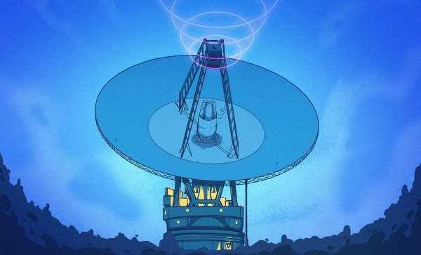
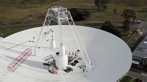
Spacing Out: A Big Anniversary, Starlink Failures Plummet, Lunar Cellphones, And A Crewed Launch

After a couple of months away we’re returning with our periodic roundup of happenings in orbit, as we tear you away from Star Trek: Discovery and The Mandalorian, and bring you up to date with some highlights from the real world of space. We’ve got a launch to look forward to this week, as well as a significant anniversary.

Continue reading “Spacing Out: A Big Anniversary, Starlink Failures Plummet, Lunar Cellphones, And A Crewed Launch”

Sending 3D Printed Parts To Mars: A Look Inside JPL’s Additive Manufacturing Center

With the Mars 2020 mission now past the halfway point between Earth and its destination, NASA’s Jet Propulsion Lab recently released a couple of stories about the 3D-printed parts that made it aboard the Perseverance rover. Tucked into its aeroshell and ready for its high-stakes ride to the Martian surface, Perseverance sports eleven separate parts that we created with additive manufacturing. It’s not the first time a spacecraft has flown with parts made with additive manufacturing technique, but it is the first time JPL has created a vehicle with so many printed parts.

To take a closer look at what 3D-printing for spaceflight-qualified components looks like, and to probe a little into the rationale for additive versus traditional subtractive manufacturing techniques, I reached out to JPL and was put in touch with Andre Pate, Additive Manufacturing Group Lead, and Michael Schein, lead engineer on one of the mission’s main scientific instruments. They both graciously gave me time to ask questions and geek out on all the cool stuff going on at JPL in terms of additive manufacturing, and to find out what the future holds for 3D-printing and spaceflight.

Continue reading “Sending 3D Printed Parts To Mars: A Look Inside JPL’s Additive Manufacturing Center”

Watching The Global Oil Trade With Satellite Imagery

The global oil market plays a large role in the geopolitical arena, and it is often in the interest of various role players to conceal the figures on production, consumption and movement of oil. This may simply to be to gain an advantage at the negotiation tables, or to skirt around international sanctions. The website [TankerTrackers] is in the business of uncovering these details, often from open source intelligence. Using satellite imagery, they are using a simple way to monitor the occupancy crude oil storage facilities around the world.

The key is in the construction of large capacity crude oil storage tanks. To prevent the flammable gasses emitted by crude oil from collecting inside partially empty tanks, they have roofs that physically float on top of the oil, moving up and down inside the steel sides as the levels change. By looking at imagery from the large number of commercial satellites that constantly photograph earth’s surface, one can determine how full the tanks are by comparing the length of a shadow inside the tank to the shadow outside the tank. Of course, you also need to know the diameter and height of a tank. Diameter is easy, just use Google Earth’s ruler tool. Height is a bit more tricky, but can often be determined by just checking the facilities’ website for ground level photos of the tanks. Of course these methods won’t give you exact numbers, but it’s good enough for rough estimates.

Another interesting detail we found perusing the [TankerTrackers] news posts (requires sign-up) is that tankers will sometimes purposefully switch off their AIS transponders, especially when heading to and from sanctioned countries such as Venezuela and Iran. Even in today’s world of omnipresent tracking technologies, it’s surprisingly easy for a massive ship to just disappear. Sometimes [TankerTrackers] will then use imagery to track down these vessels, often by just watching ports.

Thanks for the tip [Arpad Toth]!

Photo by [Terryjoyce] CC BY-SA 3.0

Hello From The NearSpace

A key challenge for any system headed up into the upper-atmosphere region sometimes called near space is communicating back down to the ground. The sensors and cameras onboard many high altitude balloons and satellites aren’t useful if the data they collect can’t be retrieved. Often times, custom antennas or beacons are added to help. Looking at the cost and difficulty of the problem, [arko] and [upaut] teamed up to try and make a turn-key solution for any near-space enthusiast by building CUBEX, a wonderful little module with sensors and clever radio that can be easily reused and repurposed.

CUBEX is meant as a payload for a high-altitude balloon with a camera, GPS, small battery, solar cell, and the accompanying power management circuits. The clever bit comes in the radio back down. By using the 434.460 Mhz band, it can broadcast around a hundred miles at 10mW. The only hardware to receive is a radio listener (a cheap RTL USB stick works nicely). Pictures and GPS coordinates stream down at 300 baud.

Their launch was quite successful and while they didn’t catch a solar eclipse, their balloon reached an impressive 33698m (110,560ft) while taking pictures. Even though it did eventually splashdown in the Pacific Ocean, they were able to enjoy a plethora of gorgeous photos thanks to their easy and cost-effective data link.

Continue reading “Hello From The NearSpace”

Lunar Ark Boldly Goes

[Sebastian and Karl-Johan] are two award-winning Danish Space Architects who are subjecting themselves to harsh, seemingly uninhabitable conditions, for science. The pair set out to build a lunar base that could land with the manned Moon missions in 2024. Like any good engineering problem, what good is a solution without testing? So the pair have placed their habitat in a Moon Analogue habitat and are staying in their habitat for two months. They want to really feel the remoteness, the bitter cold, and the fatigue of actually being on the moon. So far they are about halfway through their journey and expect to return home in December 2020.

When asking themselves where on Earth is it most like the Moon, they came up with Moriusaq, Greenland. It’s cold, remote, in constant sunlight this time of year, and it is a vast white monochrome landscape just like the moon. The first moon settlement missions are expected to be at the South Pole of the Moon, as known as the Peak of Eternal Light.
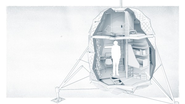
The habitat itself is a testament to the duo’s ingenuity. The whole structure folds to fit the tight space and weight requirements of rockets. Taking 2.9m3 (102 ft3) when stored, it expands 560% in volume to 17.2m3 (607 ft3). In Greenland, the structure needs to withstand -30ºC (-22ºF) and 90 km/h winds.

Because the South Pole is in constant sunlight, the temperature varies much less there than on the rest of the Moon, which makes Greenland a very good analogue temperature-wise. The foldable skin is covered in solar panels, both on the top of the bottom. The highly reflective nature of the Moon’s surface makes it easy to capture the light bouncing up onto the bottom of the habitat.

Several other bits of technology have been included onboard, like a 3D printer, a circadian light stimulation system, an algae reactor, and a weather simulation. Since both the Moon and Greenland are in constant sunlight, the pod helps regulate the circadian rhythms of the occupants by changing the hue and brightness throughout the day. The weather simulation tries to break up the monotony of space by introducing weather like a stormy day or rainbow colours.

Their expedition is still ongoing and they post daily mission updates. While some might call their foray into the unknown madness, we call it bold. Currently, NASA is planning its Artemis mission in 2024 and we hope that the lessons learning from the Lunark and other experiments culminate in a better experience for all astronauts.

Crowd Funded Jumping Cubes

The Japan Aerospace Exploration Agency (JAXA) recently contributed their Int-Ball  technology to a Kickstarter campaign operated by the Japanese electronics manufacturer / distributor Bit Trade One (Japanese site). This technology is based on the Cubli project out of the Swiss Federal Institute of Technology in Zurich (ETH Zurich), which we covered back in 2013. The Cubli-based technology has been appearing in various projects since then, including the Nonlinear Mechatronic Cube in 2016.  Alas, the current JAXA-based “3-Axis Attitude Control Module” project doesn’t have a catchy name — yet.

One interesting application of these jumping cubes, presumably how JAXA got involved with these devices, is a floating video camera that was put to use on board the International Space Station (ISS) in 2017.  The version being offered by the Kickstarter campaign doesn’t include the cameras, and you will need to provide your own a gravity-free environment to duplicate that application.  Instead, they seem to be marketing this for educational uses.  You’d better dig deep in your wallet if you want one — a fully assembled unit requires a pledge of over $5000 ( there is a “some assembly required” kit that can save you about $1000 ).  Most of us won’t be backing this project for that reason alone, but it is nice to see the march of progress of such a cool technology:  from inception to space applications to becoming available to the general public.  Thanks to [Lincoln Uehara] for sending in this tip.

Continue reading “Crowd Funded Jumping Cubes”

A Look Behind The “Big Boards” At Mission Control In The Golden Age Of NASA

Certified space-nerd and all-around retro-tech guru [Fran Blanche] has just outdone herself with a comprehensive look at how NASA ran the Mission Control “Big Boards” that provided flight data for controllers for Apollo and for the next 20 years of manned spaceflight.

We’ve got to admit, [Fran] surprised us with this one. We had always assumed that the graphs and plots displayed in front of the rows of mint-green consoles and their skinny-tie wearing engineers were video projections using eidophor projectors. And to be sure, an eidophor, the tech of which [Jenny] profiled a while back, was used on one of the screens to feed video into Mission Control, either live from the Moon or from coverage of the launch and recovery operations. But even a cursory glance at the other screens in front of “The Pit” shows projections of a crispness and clarity that was far beyond what 1960s video could achieve.

Instead, plots and diagrams were projected into the rear of the massive screens using a completely electromechanical system. Glass and metal stencils were used to project the icons, maps, and grids, building up images layer by layer. Colors for each layer were obtained by the use of dichroic filters, and icons were physically moved to achieve animations. Graphs and plots were created Etch-a-Sketch style, with a servo-controlled stylus cutting through slides made opaque with a thin layer of metal. The whole thing is wonderfully complex, completely hacky, and a great example of engineering around the limits of technology.

Hats off to [Fran] for digging into this forgotten bit of Space Race tech. Seeing something like this makes the Mission Control centers of today look downright boring by comparison.

Continue reading “A Look Behind The “Big Boards” At Mission Control In The Golden Age Of NASA”