![]() High Altitude Balloons (HAB) are a great way to get all kinds of data and shoot great photos and video, but what goes up must come down. Once the equipment has landed, one must track it down. GPS and LoRA, with its long wireless range and ease of use, are invaluable tools in tracking payloads that have returned to Earth. [Dave Akerman] has made handheld receivers to guide him to payloads, but wanted something even smaller; ideally something that could be worn on the wrist.
High Altitude Balloons (HAB) are a great way to get all kinds of data and shoot great photos and video, but what goes up must come down. Once the equipment has landed, one must track it down. GPS and LoRA, with its long wireless range and ease of use, are invaluable tools in tracking payloads that have returned to Earth. [Dave Akerman] has made handheld receivers to guide him to payloads, but wanted something even smaller; ideally something that could be worn on the wrist.
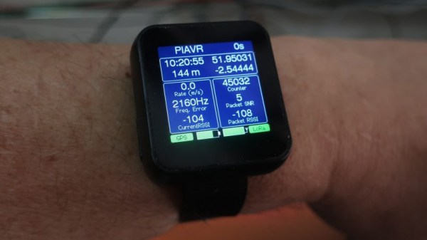
One day he came across the affordable LilyGo T-Watch which includes GPS and LoRA functionality, and he started getting ideas. The watch has the features, but the stock firmware didn’t measure up. Not to be deterred, [Dave] wrote new firmware to turn the device into a wrist-worn GPS and LoRA chase watch.
Not only is the new firmware functional, but it’s got a wonderful user interface. GitHub repository for the new firmware is here, and you can see the UI in action in the brief video embedded below.
Continue reading “Custom Firmware Makes A LoRA-Enabled HAB Tracker Watch”