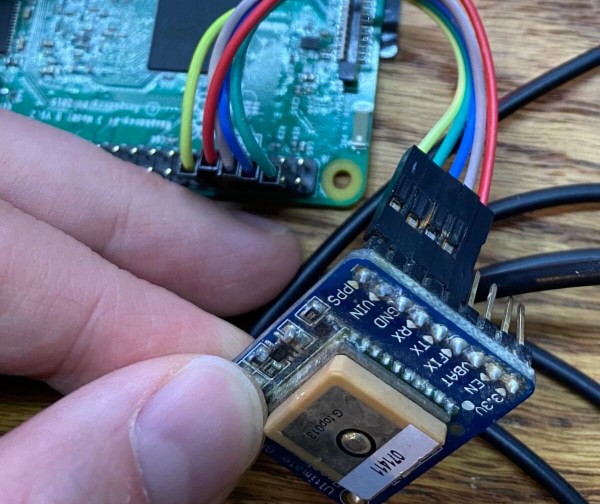
Open-Source Farming Robot Now Includes Simulations

Farming is a challenge under even the best of circumstances. Almost all conventional farmers use some combination of tillers, combines, seeders and plows to help get the difficult job done, but for those like [Taylor] who do not farm large industrial monocultures, more specialized tools are needed. While we’ve featured the Acorn open source farming robot before, it’s back now with new and improved features and a simulation mode to help rapidly improve the platform’s software.

The first of the two new physical features includes a fail-safe braking system. Since the robot uses electric geared hub motors for propulsion, the braking system consists of two normally closed relays which short the motor leads in emergency situations. This makes the motors see an extremely high load and stops them from turning. The robot also has been given advanced navigation facilities so that it can follow custom complex routes. And finally, [Taylor] created a simulation mode so that the robot’s entire software stack can be run in Docker and tested inside a simulation without using the actual robot.

For farmers who are looking to buck unsustainable modern agricultural practices while maintaining profitable farms, a platform like Acorn could be invaluable. With the ability to survey, seed, harvest, and even weed, it could perform every task of larger agricultural machinery. Of course, if you want to learn more about it, you can check out our earlier feature on this futuristic farming machine.

NTP Server Gets Time From Space

Cheap GPS units are readily available nowadays, which is great if you have something that needs to be very precisely located. Finding the position of things is one of many uses for GPS, though. There are plenty of ways to take advantage of some of the ancillary tools that the GPS uses to determine location. In this case it’s using the precise timekeeping abilities of the satellites to build a microsecond-accurate network time protocol (NTP) server.

GPS works by triangulating position between a receiver and a number of satellites, but since the satellites are constantly moving an incredibly precise timing signal is needed in order to accurately determine location from all of these variables. This build simply teases out that time information from the satellite network and ignores the location data. There are only two parts to this build, a cheap GPS receiver and a Raspberry Pi, but [Austin] goes into great detail about how to set up the software side as well including installing PPS, GPSd, and then setting up the actual NTP server on the Pi.

While this is an excellent way to self-host your own NTP server if you don’t have Internet access (or just want to do it yourself), [Austin] does note that this is probably overkill on timekeeping as far as accuracy goes. On the other hand, the Raspberry Pi has no built-in real time clock of its own, so this might actually be a cost-competitive way of timekeeping even when compared to something more traditional like a DS3231 RTC module.

Continue reading “NTP Server Gets Time From Space”

Vacuum “Tube” Might Replace GPS One Day

GPS and similar satellite navigation systems changed everything. The modern generation is far less likely to have had to fold a service station map or ask someone for directions on the side of the road. But GPS isn’t perfect. You need to see the sky, for one thing. For another, an adversary could jam or take down your satellites. Even a natural disaster could temporarily or permanently knock out your access to the satellites.

The people at Sandia National Labs worry about things like that and they want to replace GPS with quantum accelerometers and gyroscopes. The problem: those things take expensive and bulky vacuum systems and lasers. Sandia, however, has had a sealed device about the size of an avocado that weighs about a pound that could possibly do the job. Their goal is to see it work without maintenance for four more years.

This is no ordinary vacuum tube, though. It is made of titanium and sapphire. By itself, the device doesn’t do much of anything, but it shows that rubidium can be contained in a sealed chamber with no additional pumping. These quantum sensors aren’t anything new, but a tiny self-contained cold-atom sensor can pave the way for putting these sensors in vehicles like ships, aircraft, and ground vehicles. Submarines, which don’t usually have a clear shot at the sky without floating an antenna, are also candidates for the new technology.

A navigation system based on this technology uses a laser to cool the subject atoms and then measures their movements. This allows very precise determination of acceleration and rotation which allows for a more precise inertial navigation system.

If you need a refresher on how GPS works, we can explain it. If you think the idea of a module containing rubidium is far-fetched, don’t forget you can already get them for precision clock work.

Motorcycle Rally Computer Goes Open Source

Motorcycle rally racing is a high-speed, exciting, off-road motorsport that involves zipping across all types of terrain on two wheels. While riding, it’s extremely important for riders to know what’s coming up next —  turns, straightaways, stream crossings, the list goes on. Generally, this is handled by a roadbook — a paper scroll that has diagrams of each turn or course checkpoint, along with the distances between them and any other pertinent information. Of course, this needs to be paired with a readout that tells you how far you’ve traveled since the last waypoint so you’re not just guessing. This readout usually takes the form of a rally computer, a device that can display speed, distance traveled, and course heading (and some of the fancier ones have even more data available).

A roadbook with commercially-available rally computers

Frustrated with the lackluster interface and high cost associated with most rally computers on the market, [Matias Godoy] designed his own back in 2017, and was quick to realize he had a potential product. After several iterations he brought his idea to market with a small initial run, which sold out in a few hours!

He then took some time to reflect on the successful campaign. He decided that rather than continue to churn out units, he would open-source the design to make it available to everybody and see what the community could come up with. He published all of his design files to GitHub, and wrote up a wonderful blog post documenting the entire design process, from inspiration and early prototypes to his decision to go open source.

[Matias]’s project, the Open Rally Computer (formerly the Baja Pro) packages neatly in a CNC-machined case and features a nice high-visibility LCD display, a built-in GPS receiver, and an ergonomic handlebar-mounted remote. The data is crunched by an ESP32 microcontroller, which also allows for WiFi-enabled OTA updates. The end result is a beautiful and useful device that was clearly designed with great care. Love the idea but not a rally racer? If street bikes are more your thing then fear not because there’s an open source digital dashboard out there for you too.

[Nick Rehm] explains the workings of a gps-less self guided drone

Autonomous Drone Dodges Obstacles Without GPS

If you’re [Nick Rehm], you want a drone that can plan its own routes even at low altitudes with unplanned obstacles blocking its way. (Video, embedded below.) And or course, you build it from scratch.

Why? Getting a drone that can fly a path and even return home when the battery is low, signal is lost, or on command, is simple enough. Just go to your favorite retailer, search “gps drone” and you can get away for a shockingly low dollar amount. This is possible because GPS receivers have become cheap, small, light, and power efficient. While all of these inexpensive drones can fly a predetermined path, they usually do so by flying over any obstacles rather than around.

[Nick Rehm] has envisioned a quadcopter that can do all of the things a GPS-enabled drone can do, without the use of a GPS receiver. [Nick] makes this possible by using algorithms similar to those used by Google Maps, with data coming from a typical IMU, a camera for Computer Vision, LIDAR for altitude, and an Intel RealSense camera for detection of position and movement. A Raspberry Pi 4 running Robot Operating System runs the autonomous show, and a Teensy takes care of flight control duties.

What we really enjoy about [Nick]’s video is his clear presentation of complex technologies, and a great sense of humor about a project that has consumed untold amounts of time, patience, and duct tape.

We can’t help but wonder if DARPA will allow [Nick] to fly his drone in the Subterranean Challenge such as the one hosted in an unfinished nuclear power plant in 2020.

Continue reading “Autonomous Drone Dodges Obstacles Without GPS”

Omni-Wheeled Cane Steers The Visually-Impaired Away From Obstacles

Sure, there are smart canes out there, commercial and otherwise. We’ve seen more than a few over the years. But a group of students at Stanford University have managed to bring something novel to the augmented cane.

The details of an augmented cane for the visually impaired that features an omni wheel to steer them away from obstacles.Theirs features a motorized omni wheel that sweeps smoothly from left to right during normal cane operation, and when the cane senses an object that turns out to be an obstacle, the omni wheel goes into active mode, pulling the user out of the path of danger.

Tied for best part of this build is the fact that they made the project with open hardware and published all the gory details in a repo, so anyone can replicate it for about $400.

The cane uses a Raspi 4 with camera to detect objects, and a 2-D LIDAR to measure the distance to those objects. There’s a GPS and a 9-DOF IMU to find the position and orientation of the user. Their paper is open, too, and it comes with a BOM and build instructions. Be sure to check it out in action after the break.

There’s more than one way to guide people around with haptic feedback. Here’s the smartest pair of shoes we’ve seen lately.

Continue reading “Omni-Wheeled Cane Steers The Visually-Impaired Away From Obstacles”

GPS? With Starlink, We Don’t Need It Any More!

To find your position on the earth’s surface there are a variety of satellite-based navigation systems in orbit above us, and many receiver chipsets found in mobile phones and the like can use more than one of them. Should you not wish to be tied to a system produced by a national government though, there’s now an alternative. It comes not from an official source though, but as a side-effect of something else. Researchers at Ohio State University have used the Starlink satellite broadband constellation to derive positional fixing, achieving a claimed 8-metre accuracy.

The press release is light on information about the algorithm used, but since it mentions that it relies on having advance knowledge of the position and speed of each satellite we’re guessing that it measures the Doppler shift of each satellite’s signal during a pass to determine a relative position which can be refined by subsequent observations of other Starlink craft.

The most interesting takeaway is that while this technique leverages the Starlink network, it doesn’t have any connection to the service itself. Instead it’s an entirely passive use of the satellites, and though its accuracy is around an order of magnitude less than that achievable under GPS it delivers a position fix still useful enough to fit the purposes of plenty of users.

Earlier in the year there was some amusement when the British government bought a satellite broadband company under the reported impression it could plug the gap left by their withdrawal from the European Galileo project. Given this revelation, maybe they were onto something after all!

Thanks [Renze] for the tip.