How Etak Paved The Way To Personal Navigation

Our recent “Retrotechtacular” feature on an early 1970s dead-reckoning car navigation system stirred a memory of another pre-GPS solution for the question that had vexed the motoring public on road trips into unfamiliar areas for decades: “Where the heck are we?” In an age when the tattered remains of long-outdated paper roadmaps were often the best navigational aid a driver had, the dream of an in-dash scrolling map seemed like something Q would build for James Bond to destroy.

And yet, in the mid-1980s, just such a device was designed and made available to the public. Dubbed Etak, the system was simultaneously far ahead of its time and doomed to failure by the constellation of global positioning satellites being assembled overhead as it was being rolled out. Given the constraints it was operating under, Etak worked very well, and even managed to introduce some of the features of modern GPS that we take for granted, such as searching for services and businesses. Here’s a little bit about how the system came to be and how it worked.

Continue reading “How Etak Paved The Way To Personal Navigation”

Retrotechtacular: Car Navigation Like It’s 1971

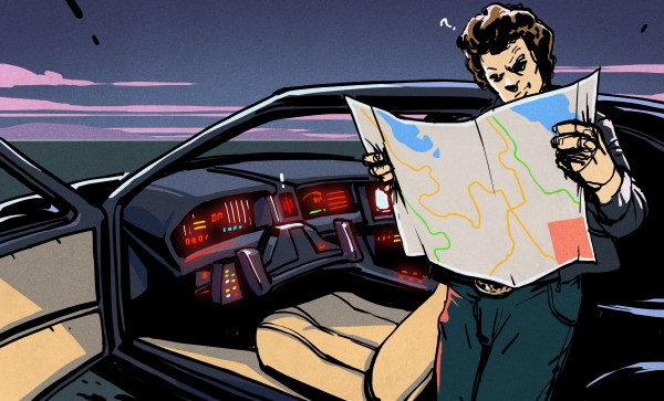
Anyone old enough to have driven before the GPS era probably wonders, as we do, how anyone ever found anything. Navigation back then meant outdated paper maps, long detours because of missed turns, and the far too frequent stops at dingy gas stations for the humiliation of asking for directions. It took forever sometimes, and though we got where we were going, it always seemed like there had to be a better way.

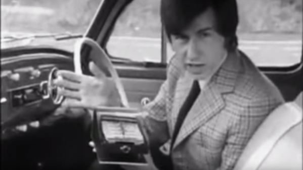
Indeed there was, but instead of waiting for the future and a constellation of satellites to guide the way, some clever folks in the early 1970s had a go at dead reckoning systems for car navigation. The video below shows one, called Cassette Navigation, in action. It consisted of a controller mounted under the dash and a modified cassette player. Special tapes, with spoken turn-by-turn instructions recorded for a specific route, were used. Each step was separated from the next by a tone, the length of which encoded the distance the car would cover before the next step needed to be played. The controller was hooked to the speedometer cable, and when the distance traveled corresponded to the tone length, the next instruction was played. There’s a long list of problems with this method, not least of which is no choice in road tunes while using it, but given the limitations at the time, it was pretty ingenious.

Dead reckoning is better than nothing, but it’s a far cry from GPS navigation. If you’re still baffled by how that cloud of satellites points you to the nearest Waffle House at 3:00 AM, check out our GPS primer for the details.

Continue reading “Retrotechtacular: Car Navigation Like It’s 1971”

Roll A Black Box For Your Wheels

Telemetric devices for vehicles, better known as black boxes, cracked the consumer scene 25 years ago with the premiere of OnStar. These days, you can get one for free from your insurance company if you want to try your luck at the discounts for safe driving game. But what if you wanted a black box just to mess around with that doesn’t share your driving data with the world? Just make one.

[TheForeignMan]’s DIY telematics box was designed to pull reports of the car’s RPM, speed, and throttle depression angle through the ODBII port. An ODBII-to-Bluetooth module sends the data to an Arduino Mega and logs it on an SD card along with latitude and longitude from a NEO-6M GPS module. Everything is powered by the car’s battery through a cigarette lighter-USB adapter.

He’s got everything tightly wrapped up inside a 3D printed box, which makes it pretty hard to retrieve the SD card. In the future, he’d like to send the data to a server instead to avoid accidentally dislodging a jumper wire.

If this one isn’t DIY enough for you to emulate, start by building your own CAN bus reader.

GPS Disciplined Oscillators

[Martin Lorton] acquired a GPS-disciplined oscillator. He wasn’t quite sure what to do with it, so he did a little research and experimentation. If you have about two hours to spare, you can watch his videos where he shares his results (see below).

The unit he mainly looks at is a Symmetricom TrueTime XL-DC, and even on eBay it ran over $500. However, [Martin] also looks at a smaller unit that is much more affordable.

Continue reading “GPS Disciplined Oscillators”

Autonomous Spaceplane Travels To 10 Km, Lands Safely 200 Km Away

Space balloons, where one sends instrument packages to the edge of space on a weather balloon, are a low-cost way to scratch the space itch. But once you’ve logged the pressure and temperature and tracked your balloon, what’s the next challenge? How about releasing an autonomous glider and having it return itself to Earth safely?

That’s what [IzzyBrand] and his cohorts did, and we have to say we’re mightily impressed. The glider itself looks like nothing to write home about: in true Flite Test fashion, it’s just a flying wing made with foam core and Coroplast reinforced with duct tape. A pair of servo-controlled elevons lies on the trailing edge of the wings, while inside the fuselage are a Raspberry Pi and a Pixhawk flight controller along with a GPS receiver. Cameras point fore and aft, a pair of 5200 mAh batteries provide the juice, and handwarmers stuffed into the avionics bay prevent freezing.

After a long series of test releases from a quadcopter, flight day finally came. Winds aloft prevented a full 30-kilometer release, so the glider was set free at 10 kilometers. The glider then proceeded to a pre-programmed landing zone over 80 kilometers from the release point. At one point the winds were literally pushing the glider backward, but the little plane prevailed and eventually spiraled down to a perfect landing.

We’ve been covering space balloons for a while, but take a moment to consider the accomplishment presented here. On a shoestring budget, a team of amateurs hit a target the size of two soccer fields with an autonomous aircraft from a range of almost 200 kilometers. That’s why we’re impressed, and we can’t wait to see what they can do after a release from the edge of space.

Continue reading “Autonomous Spaceplane Travels To 10 Km, Lands Safely 200 Km Away”

Fail Of The Week: How Not To Build Your Own DGPS Base Station

GPS is the modern answer to the ancient question about one’s place in the world yet it has its limitations. It depends on the time of flight of radio signals emitted by satellites twenty thousand kilometers above you. Like any system involving large distances and high velocities, this is bound to offer some challenges to precise measurements which result in a limit to achievable accuracy. In other words: The fact that GPS locations tend to be off by a few meters is rooted in the underlying principle of operation.

Today’s level of precision was virtually unattainable just decades ago, and we’re getting that precision with a handheld device in mere seconds. Incredible! Yet the goal posts continue to move and people are working to get rid of the remaining error. The solution is called Differential GPS or ‘DGPS’ and its concept looks surprisingly simple.

What’s fascinating is that you can use one GPS to precisely measure the error of another GPS. This is because the inherent error of a GPS fix is known to be locally constant. Two receivers next to each other pick up signals that have been affected in the same way and thus can be expected to calculate identical wrong positions. This holds true for distances up to several kilometers between individual receivers. So in order to remove the error, all you need is a GPS receiver in a known location to measure the current deviation and a way to transmit correction information to other units. DGPS does just that, using either terrestrial radio in some regions and satellites in others. Mobile solutions exist as well.

So a raspi with a USB GPS dongle in a known location should be able to act as a DGPS over IP base station, right? In theory, yes. In practice… fail.

Continue reading “Fail Of The Week: How Not To Build Your Own DGPS Base Station”

Handheld GPS Tracks All The Things

With a GPS on every smartphone, one would be forgiven for forgetting that handheld GPS units still exist. Seeking to keep accurate data on a few upcoming trips, [_Traveler] took on a custom-build that resulted in this GPS data logger.

Keeping tabs on [_Traveler] is a Ublox M8N GPS which is on full-time, logging data every 30 seconds, for up  to 2.5 days. All data is saved to an SD card, with an ESP32 to act as a brain and make downloading the info more accessible via WiFi . While tracking the obvious — like position, speed, and time — this data logger also displays temperature, elevation, dawn and dusk, on an ePaper screen which is a great choice for conserving battery.

The prototyping process is neat on this one. The first complete build used point-to-point soldering on a protoboard to link several breakout modules together. After that, a PCB design embraces the same modules, with a footprint for the ESP’s castellated edges and header footprints for USB charing board, SD card board, ePaper, etc. All of this finds a hope in a 3D printed enclosure. After a fair chunk of time coding in the Arduino IDE the logger is ready for [_Traveler]’s next excursion!

As far as power consumption in the field, [_Traveler] says the GPS takes a few moments to get a proper location — with the ESP chewing through battery life all the while — and plans to tinker with it in shorter order.

Not all GPS trackers are created equal: sometimes all you need is a stripped-down tracker for your jog, or to know exactly where every pothole is along your route.

[Via /r/electronics]