You’ve built a brand new project, and it’s a wonderful little thing that’s out and about in the world. The only problem is, you need to know its location to a decent degree of accuracy. Thankfully, GPS is a thing! With an off-the-shelf module, it’s possible to get all the location data you could possibly need. But how do you go about it, and what parts are the right ones for your application? For the answers to these questions, read on! Continue reading “How To Choose The Right GPS Module For Your Project”→
Keeping track of position is crucial in a lot of situations. On Earth, it’s usually relatively straight-forward, with systems having been developed over the centuries that would allow one to get at least a rough fix on one’s position on this planet. But for a satellite out in space, however, it’s harder. How do they keep their communications dishes pointed towards Earth?
The stars are an obvious orientation point. The Attitude and Articulation Control Subsystem (AACS) on the Voyager 1 and 2 space probes has the non-enviable task of keeping the spacecraft’s communication dish aligned precisely with a communications dish back on Earth, which from deep space is an incomprehensibly tiny target.
Back on Earth, the star tracker concept has become quite popular among photographers who try to image the night skies. Even in your living room, VR systems also rely on knowing the position of the user’s body and any peripherals in space. In this article we’ll take a look at the history and current applications of this type of position tracking. Continue reading “Star Trackers: Telling Up From Down In Any Space”→
We’re not sure how many of you out there own a boat large enough to get its own integrated computer network, but it doesn’t really matter. Even if you can’t use this project personally, it’s impossible not to be impressed with the work [mgrouch] has put into the “Bareboat Necessities” project. From the construction of the hardware to the phenomenal documentation, there’s plenty that even landlubbers can learn from this project.
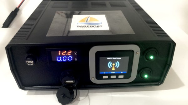
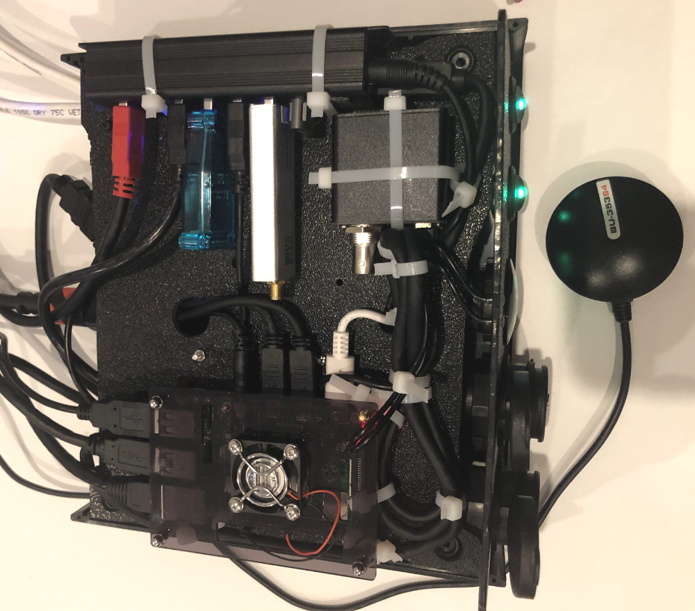
In its fully realized form, the onboard computer system includes several components that work together to provide a wealth of valuable information to the operator.
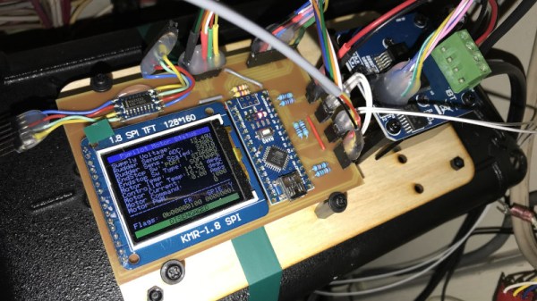
Inside the Boat Computer module
What [mgrouch] calls the “Boat Computer” contains a Raspberry Pi 4, a dAISy AIS receiver, an RTL-SDR, a GPS receiver, serial adapters, and the myriad of wires required to get them all talking to each other inside a weatherproof enclosure. As you might expect, this involves running all the connections through watertight panel mounts.
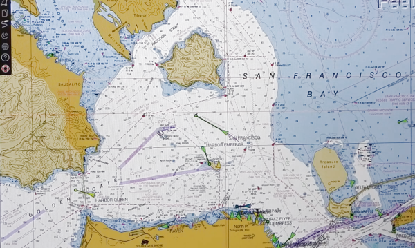
Combined with a suite of open source software tools, the “Boat Computer” is capable of interfacing with NMEA sensors and hardware, receive weather information directly from NOAA satellites, track ships, and of course plot your current position on a digital chart. The computer itself is designed to stay safely below deck, while the operator interacts with it through an Argonaut M7 waterproofed HDMI touch screen located in the cockpit.
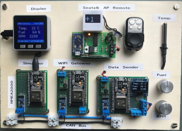
For some people, that might be enough. But for those who want to do big, [mgrouch] further details the “Boat Gateway” device. This unit contains an LTE-equipped WiFi router running OpenWrt and all the external antennas required to turn the boat into a floating hotspot. Of course it also has RJ45 jacks to connect up to the other components of the onboard system, and it even includes an M5Stack Core with LAN module so it can display a select subset of sensor readings and navigational data.
One of the biggest problems of owning an older boat (besides being a money pit – that is common to all boats regardless of age) is the lack of parts and equipment, and the lack of support for those parts if you can find them at all. Like most things, this is an area that can benefit greatly from some open source solutions, which the Open Boat Projects in Germany has been able to show. (Google Translate from German)
This group has solutions for equipment problems of all kinds for essentially any sized boat. At their most recent expo, many people were interested in open source solutions for situations where there is currently only an expensive proprietary option, such as support for various plotting devices. This isn’t the only part of this project, though. It includes many separate projects, like their solutions for autopilot and navigation. There are even complete hardware packages available, all fully documented.
Open source solutions for large, expensive things like this are often few and far between for a number of reasons. There are limited options for other modes of open source transportation too, as it seems like most large companies are not willing to give up their secrets easily. Communities like this, however, give us hope that people will have other options for repairing their vehicles without having to shell out too much money.
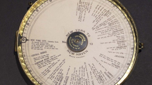
Many of us now carry a phone that can give us detailed directions from where we are to a destination of our choosing. This luxury became commonplace over the last decade plus, replacing the pen-and-paper solution of consulting a map to plan a trip and writing down steps along the way. During the trip we would have to manually keep track of which step we’re on, but wouldn’t it have been nice to have the car do that automatically? [Ars Technica] showed us that innovators were marketing solutions for automatic step by step driving directions in a car over a 100 years ago.
Systems like the Jones Live-Map obviously predated GPS satellites, so they used vehicle odometry. Given a starting point and a mechanical link to the drivetrain, these machines can calculate miles traversed and scroll to the corresponding place in the list of instructions. This is a concept that has been used in many different contexts since, including the “Next Bus in 7 Minutes” type of display at bus stops. Because a bus runs a fixed route, it is possible to determine location of a bus given its odometer reading transmitted over radio. This was useful before the days of cheap GPS receiver and cellular modems. But the odometry systems would go awry if a bus rerouted due to accidents or weather, and obviously the same would apply to those old school systems as well. Taking a detour or, as the article stated, even erratic driving would accumulate errors by the end of the trip.
The other shortcoming is that these systems predated text-to-speech, so reading the fine print on those wheels became a predecessor to today’s distracted driving problem. One of the patent diagrams explained the solution is to hand the device to a passenger to read. But if there’s a copilot available for reading, they can just as easily track the manual list of directions or use a map directly. The limited utility relative to complexity and cost is probably why those systems faded away. But the desire to solve the problem never faded, so every time new technology became available, someone would try again. Just as they did with a tape casette system in the 1970s and the computerized Etak in the 1980s.
The build is based around OpenPlotter, which uses a battery of marine-ready software to handle routing charts, autopiloting, and providing a compass heading for navigation. Naturally, it all runs on a Raspberry Pi. In combination with PyPilot, it can be used to let the vessel drive itself around a series of waypoints, allowing you to soak up the atmosphere on the water without having to constantly steer the craft.
[Timo] ran into some issues, however, with the hardware side of things. Existing implementations for motor control to drive the rudder weren’t quite cutting it, so the system was reworked to run with a robust H-bridge and some fresh Arduino code. This was combined with a custom rudder sensor built with a potentiometer and some 3D printed gears. Future work aims to double up the rudder sensors for redundancy, something we should all consider at times.
Overall, the system is starting to come together, and [Timo]’s enjoying letting his boat think for itself. He notes that it’s very important to keep an eye on the boat while operating in this condition, lest it veer off course – many a boat has been lost this way. We’re always supporters of a mature attitude towards autonomous vehicle operations!
As the Raspberry Pi in its various forms continues to flow into the wild by the thousands, it’s interesting to see its user base expand outside beyond the hacker communities. One group of people who’ve also started taking a liking to it is sailing enthusiasts. [James Conger] is one such sailor, and he built his own AIS enabled chart plotter for a fraction of the price of comparable commercial units.
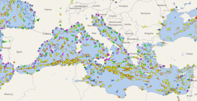
AIS transponders in the Mediterranean. VesselFinder
Automatic Identification System (AIS) is a GPS tracking system that uses transponders to transmit a ship’s position data to other ships or receiver stations in an area. This is used for collision avoidance and by authorities (and hobbyists) to keep an eye on shipping traffic, and allow for stricken vessels to be found easily. [James]’ DIY chart plotter overlays the received AIS data over marine charts on a nice big display. A Raspberry Pi 3B+, AIS Receiver Hat, USB GPS dongle and a makes up the core of the system. The entire setup cost about $350. The Pi runs OpenCPN, an open source chart plotter and navigation software package that [John] says is rivals most commercial software. As most Pi users will know the SD card is often a weak link, so it’s probably worth having a backup SD card with all the software already installed just in case it fails during a voyage.