Junk Bin Cyberdish Turns You Into The Satellite Tracker

The good thing about listening in on satellites is that they tend to beam down all kinds of juicy information from their lofty perches. The bad thing about satellites is that to stay in those orbits, they’ve got to be moving really fast, and that means that you’ve got to track them if you want to keep a nice consistent signal during a pass. And that can lead to all sorts of complexity, with motorized two-axis mounts and fancy tracking software.

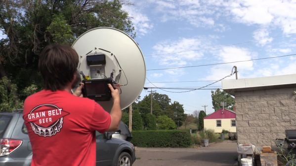
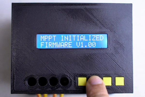
Or does it? Not if you’re willing to act as the antenna mount, which is the boat [Gabe] from the saveitforparts channel on YouTube recently found himself in when searching for L-band signals from the GOES satellite. His GOES setup uses a 30″ (0.8 m) dish repurposed from a long-range wireless networking rig. Unfortunately, the old security camera pan-tilt unit it was mounted on wasn’t quite up to satellite tracking duty, so [Gabe] pulled the dish off and converted it to manual tracking.

With a freshly wound helical antenna and a SAWbird LNA at the focal point, the dish proved to be pretty easy to keep on track manually, while providing quite the isometric workout. Aiming was aided by an app called Stellarium which uses augmented reality to point out objects in the night sky, and a cheap tablet computer was tasked with running SDR++ and capturing data. Sadly, neither of these additions brought much to the party, with the latter quickly breaking and the former geared more toward stargazing than satellite snooping. But with some patience — and some upper-body strength — [Gabe] was able to track GOES well enough with the all-in-one “cyberdish” to get some usable images. The whole saga is documented in the video after the break.

Kudos to [Gabe] for showing us what can be accomplished with a little bit of junk and a lot of sticktoitiveness. He promises that a legit two-axis mount is in the works, so we’ll be on the lookout for that. We’ve seen a few of those before, and [Chris Lott] did a great overview of satellite tracking gear a while back, too.

Continue reading “Junk Bin Cyberdish Turns You Into The Satellite Tracker”

The International Space Station Is Always Up There

Thanks to its high orbital inclination, the International Space Station (ISS) eventually passes over most inhabited parts of the Earth. Like other artificial satellites, though, it’s typically only visible overhead during passes at sunrise and sunset. If you’d like to have an idea of where it is beyond the times that it’s directly visible, take a look at this tabletop ISS tracking system created by [dpelgrift].

The tracker uses an Adafruit Feather inside its enclosure along with a Featherwing ESP32 WiFi co-processor. Together they direct a 3D printed rocket-shaped pointing device up and down by way of a SG90 micro-servo, while a 28BYJ-48 stepper motor provides rotation.

This setup allows it to take in all of the information required to calculate the Station’s current position. The device uses the current latitude and longitude, as well as its compass heading, and combines that with data pulled off the net to calculate which direction it should be pointing.

While it might seem like a novelty or programming challenge, this project could be useful for plenty of people who just want to keep track so they know when to run outside and see the Station pass by, or even by those who use the radio repeater aboard the ISS. The repeater on the ISS and plenty of other satellites are available to amateur radio operators for long-distance VHF and UHF communication like we’ve seen in projects like these.

A small round NRF51822 board glued to the underside of a mailbox lid, with a small vibration sensor attached

Check Your Mailbox Using The AirTag Infrastructure

When a company creates an infrastructure of devices, we sometimes subvert this infrastructure and use it to solve tricky problems. For example, here’s a question that many a hacker has pondered – how do you detect when someone puts mail into your mailbox? Depending on the availability of power and wireless/wired connectivity options, this problem can range from “very easy” to “impractical to solve”. [dakhnod] just made this problem trivial for the vast majority of hackers, with the FakeTag project – piggybacking off the Apple’s AirTag infrastructure.

This project uses a cheap generic CR2032-powered NRF51822 board, sending the mailbox status over the FindMy system Apple has built for the AirTag devices. For the incoming mail detection, he uses a simple vibration sensor, glued to the flap lid – we imagine that, for flap-less mailboxes, an optical sensor or a different kind of mechanical sensor could be used instead. Every time someone with a FindMy-friendly iPhone passes by [dakhnod]’s mailbox, he gets an update on its status, with a counter of times the sensor has been triggered. [dakhnod] estimates that the device could run for up to a year on a single battery.

Continue reading “Check Your Mailbox Using The AirTag Infrastructure”

Low Power Mode For Custom GPS Tracker

GPS has been a game-changing technology for all kinds of areas. Shipping, navigation, and even synchronization of clocks have become tremendously easier thanks to GPS. As a result of its widespread use, the cost of components is also low enough that almost anyone can build their own GPS device, and [Akio Sato] has taken this to the extreme with efforts to build a GPS tracker that uses the tiniest amount of power.

This GPS tracker is just the first part of this build, known as the air station. It uses a few tricks in order to get up to 30 days of use out of a single coin cell battery. First, it is extremely small and uses a minimum of components. Second, it uses LoRa, a low-power radio networking method, to communicate its location to the second part of this build, the ground station. The air station grabs GPS information and sends it over LoRa networks to the ground station which means it doesn’t need a cellular connection to operate, and everything is bundled together in a waterproof, shock-resistant durable case.

[Akio Sato] imagines this unit would be particularly useful for recovering drones or other small aircraft that can easily get themselves lost. He’s started a crowdfunding page for it as well. With such a long battery life, it’s almost certain that the operator could recover their vessel before the batteries run out of energy. It could also be put to use tracking things that have a tendency to get stolen.

Tracking Maximum Power Point For Solar Efficiency

In days of yore when solar panels weren’t dirt cheap, many people (and even large energy companies) used solar trackers to ensure their panels were always physically pointed at the sun to make sure they harvested every watt of energy possible. Since the price of panels has plummeted, though, it’s not economical to install complex machines to track the sun anymore. But all solar farms still track something else, called the Maximum Power Point (MPP), which ensures that even stationary panels are optimized for power production.

While small MPP trackers (MPPT) are available in solar charge controllers in the $200 range that are quite capable for small off-grid setups, [ASCAS] aka [TechBuilder] decided to roll out an open source version with a much lower price tag since most of the costs of these units are in R&D rather than in the actual components themselves. To that end, the methods that he uses for his MPPT are essentially the same as any commercial unit, known as synchronous buck conversion. This uses a specially configured switch-mode power supply (SMPS) in order to match the power output of the panels to the best power point for any given set of conditions extremely rapidly. It even works on many different battery configurations and chemistries, all configurable in software.

This build is incredibly extensive and goes deep into electrical theory and design choices. One design choice of note is the use of an ESP32 over an Arduino due to the higher resolution available when doing analog to digital conversion. There’s even a lengthy lecture on inductor core designs, and of course everything on this project is open source. We have also seen the ESP32 put to work with MPPT before, although in a slightly less refined but still intriguing way.

Thanks to [Sofia] for the tip!

Continue reading “Tracking Maximum Power Point For Solar Efficiency”

Keep An Eye On Your Bike With This DIY GPS Tracker

Owning a bike and commuting on it regularly is a great way to end up with your bike getting stolen, unfortunately. It can be a frustrating experience, and it can be particularly difficult to track a bike down once it’s vanished. [Johan] didn’t want to be caught out, however, and thus built a compact GPS tracker to give himself a fighting chance to hang on to his ride.

It’s built around the Arduino MKR GSM, a special Arduino built specifically for Internet of Things project. Sporting a cellular modem onboard, it can communicate with GSM and 3G networks out of the box. It’s paired with the MKR GPS shield to determine the bike’s location, and a ADXL345 3-axis accelerometer to detect movement. When unauthorised movement is detected, the tracker can send out text messages via cellular connection in order to help the owner track down the missing bike.

The tracker goes for a stealth installation, giving up the deterrent factor in order to lessen the chance of a thief damaging or disabling the hardware. It’s a project that should give [Johan] some peace of mind, though of course knowing where the bike is, and getting it back, are two different things entirely. We’ve seen creative techniques to build trackers for cats, too. It used to be the case that such “tracking devices” were the preserve of movies alone, but no longer. If you’ve got your own build, be sure to let us know on the tipline!


Get Apple To Track Your Bluetooth Devices For You

Apple’s “Find My” service allows users to track their missing devices by leveraging a worldwide network of location-aware iGadgets. With millions of iPhones and Macs out in the wild listening for the missing device’s Bluetooth advertisements and relaying their findings to the Cupertino Mothership, it’s a highly effective way of tracking hardware so long as it stays in relatively urban areas. Unfortunately, the system is completely proprietary and non-Apple devices aren’t invited to play.

Or at least, that used to be the case. A project recently released by the [Secure Mobile Networking Lab] called OpenHaystack demonstrates how generic devices can utilize Apple’s Find My network by mimicking the appropriate Bluetooth Low Energy (BLE) broadcasts. Currently they have a firmware image for the BBC micro:bit, as well as a Python script for Linux, that will allow you to spin up an impromptu Find My target. But the team has also published all the information required to implement similar functionality on other BLE-capable devices and microcontrollers, so expect the list of supported hardware to grow shortly.

Diagram showing how the Apple Find My system works
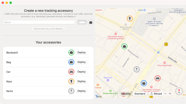
Somewhat ironically, while OpenHaystack allows you to track non-Apple devices on the Find Me tracking network, you will need a Mac computer to actually see where your device is. The team’s software requires a computer running macOS 11 (Big Sur) to run, and judging by the fact it integrates with Apple Mail to pull the tracking data through a private API, we’re going to assume this isn’t something that can easily be recreated in a platform-agnostic way.
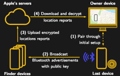
 Beyond the occasional Hackintosh that might sneak in there, it looks like Tim Cook might have the last laugh after all.

It’s not immediately clear how difficult it will be for Apple to close this loophole, but the talk of utilizing a private API makes us think there might be a built-in time limit on how long this project will be viable. After all, Big Tech doesn’t generally approve of us peons poking around inside their machinations for long. Though even if Apple finds a way to block OpenHaystack, it’s expected the company will be releasing “AirTags” sometime this year which will allow users to track whatever objects they like through the system.