Navigation Thing: Four Days, Three Problems, And Fake Piezos

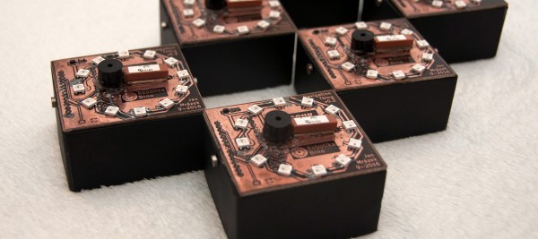
The Navigation Thing was designed and built by [Jan Mrázek] as part of a night game activity for high school students during week-long seminar. A night-time path through a forest had stations with simple tasks, and the Navigation Thing used GPS, digital compass, a beeper, and a ring of RGB LEDs to provide a bit of “Wow factor” while guiding a group of students from one station to the next. The devices had a clear design direction:

“I wanted to build a device which a participant would find, insert batteries, and follow the beeping to find the next stop. Imagine the strong feeling of straying in the middle of the night in an unknown terrain far away from civilization trusting only a beeping thing you found. That was the feeling I wanted to achieve.”

The Navigation Things (there are six in total) guide users to fixed waypoints with GPS, a digital compass, and a ring of WS2812 LEDs — but the primary means of feedback to the user is a beeping that gets faster as you approach the destination. [Jan] had only four days to make all six units, which was doable. But as most of us know, delivering on a tight deadline is often less about doing the work you know about, and more about effectively handling the unexpected obstacles that inevitably pop up in the process.

Continue reading “Navigation Thing: Four Days, Three Problems, And Fake Piezos”

Netbook Finds New Home In A Jaguar Dashboard

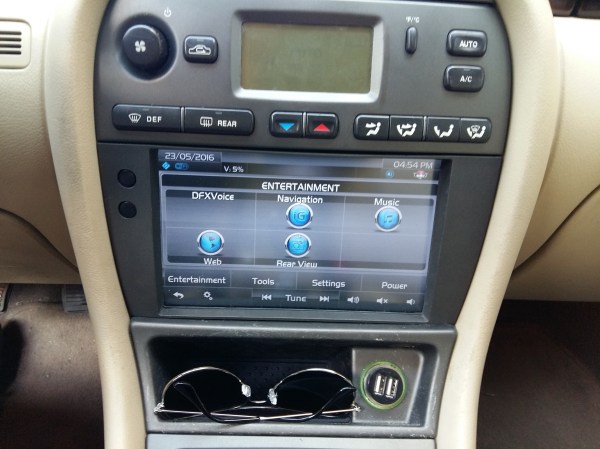
You’d figure a luxury car like a Jaguar would have a high-end infotainment system. [RichTatham]’s Jag did, but the trouble was that it was a high-end system when a cassette deck and trunk-mounted CD changer were big deals. So naturally, he saw this as a great reason to modernize the system by grafting a netbook into the Jag’s dash. The results are fantastic!

Even though the Jag’s original system didn’t have much left that made it into the final project — the navigation system, CD changer, phone and even the amps ended up on the scrap heap — at least the dashboard instrument cluster proved to be very amenable to his mods. By substituting a climate control cluster from another model into his car, he was able to free up tons of space for the netbook’s 8″ display. A custom bezel and some clever brackets completed the head-end of the new system, and the look is as close to a factory install as you’re likely to find in an aftermarket mod. With the netbook stashed in the bay vacated by the OEM system, a GPS dongle, and a USB sound card connected to a 5.1 amp using the original speakers this jag is ready to bump. We bet that the system sounds as good as it looks, and with the added functionality of a Windows PC to boot.

For obvious reasons, lots of computers make it into hackers’ dashboards, whether they be Windows like this one, Samsung tablets or Nexus tablets running Android, and even phones. But [Rich]’s build is top notch, and takes in-car integrations to the next level.

[via r/diy]

Stepping Out In Style With Top Hat Navigation

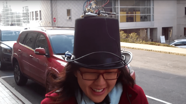
Wearable tech is getting to be a big thing. But how we interface with this gear is still a bit of a work in progress. To explore this space, [Bruce Land]’s microcontroller course students came up with an acoustic interface to assist with navigation while walking. With style, of course.

[Bruce], from the Cornell University School of Electrical and Computer Engineering, has been burning up the Hackaday tips line with his students’ final projects. Here’s the overview page for the Sound Navigation Hat. It uses a PIC32 with GPS and compass. A lot of time was spent figuring out how to properly retrieve and parse the GPS data, but for us the interesting bits on that page are how the directional sound was put together.

Audio tones are fed to earbuds with phase shift and amplitude to make it seem like the sound is coming from the direction you’re supposed to walk. Navigation is all based on pre-programmed routes which are selected using a small LCD screen and buttons. One thing’s for sure, the choice of headwear for the project is beyond reproach from a fashion standpoint – engineering has a long history with the top hat, and we think it’s high time it made a comeback.

Is this a practical solution to land navigation? Of course not. But it could be implemented in smartphone audio players for ambient turn-by-turn navigation. And as a student project, it’s a fun way to demonstrate a novel interface. We recently covered a haptic navigation interface for the visually impaired that uses a similar principle. It’ll be interesting to see if either of these interfaces goes anywhere.

Continue reading “Stepping Out In Style With Top Hat Navigation”

Navigating The Oceans Is Deadly Without A Clock

I came across an interesting question this weekend: how do you establish your East/West location on the globe without modern technology? The answer depends on what you mean by “modern”, it turns out you only have to go back about three centuries to find there was no reliable way. The technology that changed that was a clock; a very special one that kept accurate time despite changing atmospheric conditions and motion. The invention of the Harrison H1 revolutionized maritime travel.

We can thank Andy Weir for getting me onto this topic. I just finished his amazing novel The Martian and I can confirm that George Graves’ opinion of the high quality of that novel is spot on. For the most part, Andy lines up challenges that Mark Watney faces and then engineers a solution around them. But when it came to plotting location on the surface of Mars he made just a passing reference to the need to have accurate clocks to determine longitude. I had always assumed that a sextant was all you needed. But unless you have a known landmark to sight from this will only establish your latitude (North/South position).

Continue reading “Navigating The Oceans Is Deadly Without A Clock”

Arduino GPS

A Simple And Inexpensive GPS Navigation Device

There are plenty of GPS navigation units on the market today, but it’s always fun to build something yourself. That’s what [middelbeek] did with his $25 GPS device. He managed to find a few good deals on electronics components online, including and Arduino Uno, a GPS module, and a TFT display.

In order to get the map images on the device, [middelbeek] has to go through a manual process. First he has to download a GEOTIFF of the area he wants mapped. A GEOTIFF is a metadata standard that allows georeferencing information to be embedded into a TIFF image file.  [middelbeek] then has to convert the GEOTIFF into an 8-bit BMP image file. The BMP images get stored on an SD card along with a .dat file that describes the boundaries of each BMP. The .dat file was also manually created.

The Arduino loads this data and displays the correct map onto the 320×240 TFT display. [middelbeek] explains on his github page that he is currently unable to display data from two map files at once, which can lead to problems when the position moves to the edge of the map. We suspect that with some more work and tuning this system could be improved and made easier to use, of course for under $25 you can’t expect too much.

Low-Power Orientation Tracker And An Optimized Math Library For The MSP430

MSP430 Orientation Tracker

Orientation trackers can be used for a ton of different applications: tracking mishandled packages, theft notification of valuables, and navigation are just a few examples! A recent blog post from Texas Instruments discusses how to build a low-cost and low-power orientation tracker with the MSP430.

Based on the MSP430 LaunchPad and CircuitCo’s Educational BoosterPack, the orientation tracker is very simple to put together. It can also be made wireless using any of the wireless BoosterPacks with a Fuel Tank BoosterPack, or by using the BLE Booster Pack with a built in Lithium Battery circuitry. TI provides all the necessary code and design files in their reference application for getting your orientation tracker up and running. Be sure to see the device in action after the break! This project not only involves building a low-power orientation tracker, but also showcases IQmathLib, a library of optimized fixed point math functions on the MSP430. One of the more challenging aspects of using small MCUs such as the MSP430 or Arduino is how inefficient built in math libraries are. Check out the IQmathLib, it greatly improves upon the built in math functions for the MSP430.

It would be interesting to see this project modified to be a DIY pedometer or be used on a self-balancing robot. It would also be interesting to see the IQmathLib ported to other micros, such as the Arduino. Take a look and see how you can use this reference design in your own projects!

Continue reading “Low-Power Orientation Tracker And An Optimized Math Library For The MSP430”