A Homebrew GPS Correction System For DIY Land Surveying

For those of you rushing to the comment section after reading the title to tell [Ben Dauphinee] that his DIY land surveying efforts are for naught because only a licensed surveyor can create a legally binding property description, relax — he already knows. But what he learned about centimeter-resolution GPS is pretty interesting, especially for owners of large rural properties like him.

[Ben]’s mapping needs are less rigorous than an official survey; he just wants to get the locations of features like streams and wood lines, and to get topographic elevations so that he has a general “lay of the land” for planning purposes. He originally engaged a surveyor for that job, but after shelling out $4,600 to locate a single property line, he decided to see what else could be done. Luckily, real-time kinematics, or RTK, holds the key. RTK uses a fixed GPS station to provide correction signals to a mobile receiver, called a rover. If the fixed station’s position is referenced to some monument of known position, the rover’s position can be placed on a map to within a couple of centimeters.

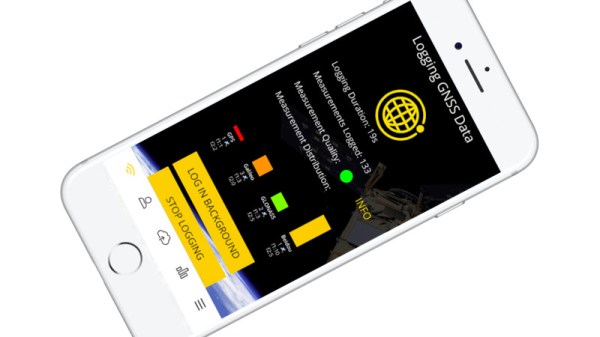
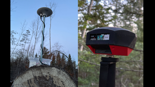
To build his own RTK system, [Ben] used some modules from SparkFun. The fixed station has an RTK breakout board and a multi-band GNSS antenna to receive positioning data, along with a Raspberry Pi to run the RTK server. An old iPhone with a prepaid SIM provides backhaul to connect to the network that provides correction data. [Ben]’s rover setup also came mainly from SparkFun, with an RTK Facet receiver mounted on a photographer’s monopod. Once everything was set up and properly calibrated, he was able to walk his property with the rover and measure locations to within 4 centimeters.

This was not an inexpensive endeavor — all told, [Ben] spent about $2,000 on the setup. That’s a lot, especially on top of what he already paid for the legal survey, but still a fraction of what it would have cost to have a surveyor do it, or to buy actual surveyor’s equipment. The post has a ton of detail that’s worth reading for anyone interested in the process of mapping and GPS augmentation.

A RPI HAT For Synchronized Measurements

A team from the Institute for Automation of Complex Power System (ACS) at RWTH Aachen University have been working for a while on the analysis of widely distributed power systems. In a drive to move away from highly specialised (and expensive) electronics platforms, they have produced some instrumentation designed to operate with the Raspberry Pi platform, and an open source software stack. They call the platform the SMU (Synchronised Measurement Unit.) The SMU consists of a HAT sitting on an RPi3, inside a 3D printed box that is intended to attach to a DIN rail. After all, this is supposed to be an industrial platform.

Hardware wise, the star of the show is the Texas Instruments ADS8588S which is a 16-bit 8-channel simultaneous sampling ADC. This is quite a nice device, with 200 kSPS throughput and a per-channel programmable front end, packaged in a hacker-friendly 64-pin QFP. What makes this project interesting however, is how they solved the problem of controlling the sampled data acquisition and synchronisation.

1-PPS and BUSY edges converted to levels, then OR’d to trigger the DMA

By programming the ADC into byte-parallel mode, then using the BCM2837 Secondary Memory Interface (SMI) block together with the DMA, samples are transferred into memory with minimal CPU overhead. An onboard U-Blox Max-M8 GNSS module provides a 1PPS (top of second pulse) signal, which is combined with the ADC busy signal in a very simple manner, enabling both sample rate control as well as synchronisation between multiple units spread out in an installation. They reckon they can get synchronisation to within 180 ns of top-of-second, which for measuring relatively slow-changing power systems, should be enough. The HAT PCB was created in KiCAD and can be found in the SMU GitHub hardware section, making it easy to modify to your needs, or at least adjust the design to match the parts you can actually get your hands on.

Continue reading “A RPI HAT For Synchronized Measurements”

Around GPS In 100 Videos

Do you know what the IODC word in GPS data means? If so, great! If not, head over to see the 32nd of [Michel van Biezen’s] 100-part video series on GPS. You probably want to watch the other 31 videos before he gets too much further ahead of you, too. [Michel] reminds you of that professor you had in college who knows a whole lot about something. In fact, scanning his YouTube channel, he knows a lot about many topics ranging from optics, chemistry, kalman filters, and lots of electronics.

There is a dedicated playlist for the GPS videos dating back to 2016. So 32 videos in about six years. So you might have a little time to catch up.  While the first video is pretty introductory as you might expect, by the time you get to video 7 the topics switch to things like the C/A code, BPSK, and gory details of all the frame data, including the IODC word.

Continue reading “Around GPS In 100 Videos”

Knowing Your Place: The Implications Of GPS Spoofing And Jamming

Artificial satellites have transformed the world in many ways, not only in terms of relaying communication and for observing the planet in ways previously inconceivable, but also to enable incredibly accurate navigation. A so-called global navigation satellite system (GNSS), or satnav for short, uses the data provided by satellites to pin-point a position on the surface to within a few centimeters.

The US Global Positioning System (GPS) was the first GNSS, with satellites launched in 1978, albeit only available to civilians in a degraded accuracy mode. When full accuracy GPS was released to the public under the 1990s Clinton administration, it caused a surge in the uptake of satnav by the public, from fishing boats and merchant ships, to today’s navigation using nothing but a smartphone with its built-in GPS receiver.

Even so, there is a dark side to GNSS that expands beyond its military usage of guiding cruise missiles and kin to their target. This comes in the form of jamming and spoofing GNSS signals, which can hide illicit activities from monitoring systems and disrupt or disable an enemy’s systems during a war. Along with other forms of electronic warfare (EW), disrupting GNSS signals form a potent weapon that can render the most modern avionics and drone technology useless.

With this in mind, how significant is the threat from GNSS spoofing in particular, and what are the ways that this can be detected or counteracted?

Continue reading “Knowing Your Place: The Implications Of GPS Spoofing And Jamming”

Need A Snack From Across Town? Send Spot!

[Dave Niewinski] clearly knows a thing or two about robots, judging from his YouTube channel. Usually the projects involve robot arms mounted on some sort of wheeled platform, but this time it’s the tune of some pretty famous yellow robot legs, in the shape of spot from Boston Dynamics. The premise is simple — tell the robot what snacks you want, entirely by voice command, and off he goes to fetch. But, we’re not talking about navigating to the fridge in the same room. We’re talking about trotting out the front door, down the street and crossing roads to visit favorite restaurant. Spot will order the snacks and bring them back, fully autonomously.

Spot’s depth cameras provide localized navigation and object avoidance information
Local AI vision system handles avoiding those pesky moving objects

There are multiple things going here, all of which are pretty big computational tasks. Firstly, there is no cloud-based voice control, ala Google voice or Alexa. The robot works on the premise of full autonomy, which means no internet connectivity for any aspect. All voice recognition, voice-to-text, and speech synthesis are performed locally using the NVIDIA Riva GPU-based AI speech SDK, running on the local NVIDIA Jetson AGX Orin carried on Spot’s back. A front-facing webcam supplies the audio feed for this. The voice recognition application listens for the wake phrase, then turns the snack order into text, for later replay when it gets to the destination. Navigation is taken care of with a Microstrain RTK GNSS module, which has all the needed robustness, such as dual antennas, and inertial fallback for those regions with a spotty signal. Navigation is no use out in the real world on its own, which is where Spot’s depth sensor cameras come in. These enable local obstacle avoidance, as per the usual spot behavior we’ve all seen before. But what about crossing the road without getting tens of thousands of dollars of someone else’s hardware crushed by a passing truck? Spot’s onboard streaming cameras are fed into the NVIDIA dash cam net AI platform which enables real-time recognition of moving obstacles such as cars, humans and anything else that might be wandering around and get in the way. All in all a cool project showing the future potential of AI in robotics for important tasks, like fetching me a beer when I most need it, even if it comes from the local corner shop.

We love robots around here. Robots can mow your lawn, navigate inside your house with a little help from invisible QR Codes, even help out with growing your food. The robot-assisted future long promised, may now be looking more like the present.

Continue reading “Need A Snack From Across Town? Send Spot!”

Monitor Space Weather And The Atmosphere With Your Cellphone!

Above our heads, the atmosphere is a complex and unpredictable soup of gasses and charged particles subject to the influence of whatever the Sun throws at it. Attempting to understand it is not for the faint-hearted, so it has for centuries been the object of considerable research. A new project from the European Space Agency and ETH Zurich gives the general public the chance to participate in that research in a small way, by crowdsourcing atmospheric data gathering to a mobile phone app. How might a mobile phone observe the atmosphere? The answer lies in their global positioning receivers, which can track minute differences in the received signals caused by atmospheric conditions. By gathering as much of this data as possible, the ESA scientists will gain valuable insights into atmospheric conditions as they change across the globe.

The app requires an Android phone equipped with a dual frequency satnav receiver, and having been duly installed on the trusty Hackaday Motorola it in turn started picking up all the different constellations of satellites. The instructions are to leave it somewhere such as a windowsill with an unobstructed view of the sky and move it as little as possible, to which we’d add clicking the “Log in background” button and connectign a charger. There’s a promise that uploaders can win prizes, so aside from contributing to scientific discovery there might be an unexpected benefit. More details on the app can be found here, meanwhile many readers will know that this isn’t the only crowdsourced atmospheric data gathering effort.

Wooden Linear Clock Aided By GPS

The notion of segmenting and quantizing the day into discrete segments of time is perhaps one of the most human things we do. Heralding back to a simpler era when a day was just a progression of sunrise to sunset, [James Wilson] created a beautiful linear clock that shows time as progress throughout the day.

For previous projects, [James] had used nixie tubes but the headache of the inverters, high voltages, and tight spaces led him to instead use mini-LED’s. Two PCBs were manufactured, one as the display and one to hold the GNSS module as it works best when mounted horizontally to point at the sky. Two rows of 112 tightly packed LEDs make a great stand-in for bar graph style tubes and are are controlled by TLC5926 shift registers. The venerable STM32G0 was chosen as the microcontroller to power the clock. With the help of some approximating functions and the location provided by the GNSS module [James] had the position of the sun which he then could turn into a % of progress through the sky.

The enclosure was modeled after the mid-century modern look and made of several pieces of wood CNC’d and then glued together. Machining it out of a solid piece of wood would have been difficult as finding long enough end mills that could carve out the interior is tricky. We think the resulting clock looks wonderful and the walnut accents the maple nicely.

The writeup is highly detailed and we love the honest explanations of what choices were made and why. The code is available on GitHub. Or if perhaps you’d rather eschew the LED’s and go for something more physical there’s always this ratcheting linear clock to draw inspiration from.